Interesting Aircraft on Mode-S/Flight Tracking

Status
Not open for further replies.

smason

Member
Joined
Dec 20, 2006
Messages
1,175
Location
Alberta Canada, Eh!
Still learning this stuff, this one caught my eye today, USAF plane.
Sorry about the format, haven't figured out reports yet

ADS AE01D1
Reg 62-4130
Flight SNOOP57
Lat 0.00000
Long 0.00000
Alt 36000'
Course 0.0°
Speed 0.0kts
Time 19:56:52UTC
Msg 6
USR *S
Type R135
Sqwk 2411
 

robertmac

Member
Premium Subscriber
Joined
Jun 6, 2005
Messages
2,298
Not sure if these qualify as interesting aircraft but one by the Alberta/Montana border and another recently went by Calgary:
Airline: Emirates Sky Cargo
Flight: UAE9993
From: Los Angeles, Los Angeles (LAX)
To: Copenhagen, Kastrup (CPH)
Aircraft: Boeing 777-F1H (B77F)
ETA: 12:19 UTC (in 09:32)
Reg: A6-EFD
Altitude: 33000 ft (10058 m)
Speed: 473 kt (876 km/h, 544 mph)
Track: 28°
Hex: 896228
Squawk: 0000
Pos: 49.0868 / -113.1309

And
Airline: Emirates
Flight: EK216
From: Los Angeles, Los Angeles (LAX)
To: Dubai, Dubai (DXB)
Aircraft: Boeing 777-31H(ER) (B77W)
Reg: A6-EGE
Altitude: 31000 ft (9449 m)
V/S: -128 fpm
Speed: 472 kt (874 km/h, 543 mph)
Track: 24°
Hex: 89617D
Squawk: 0000
Pos: 53.9385 / -113.3135
 

VE5JL

Member
Premium Subscriber
Joined
Mar 4, 2003
Messages
353
Location
Saskatchewan VE5 Land
From the past couple days....

ICAO: A781A4
Mark: HZ-MS5B
Type: Gulfstream G5
- owned by "Saudi Medevac" (!)

ICAO: A9FBED
Mark: N742WA
Type: Boeing 747-412 Cargo
Callsign: WOA9881
- World Airways Cargo flying from Leipzig to Travis AFB. Wonder what was in that cargo hold?

ICAO: A020A1
Mark: N107VS
Type: Gulfstream G5-SP
- This is Visa America's corporate jet. Who owns it? "Wilmington Trust Co Trustee" - in other words, "the bank", but not Visa. :)

For anyone interested in getting involved in this, here's my cost breakdown:

Cost for the DVB-T (RTL dongle): $39.95 USD on eBay from "nooelec"
PlanePlotter registration: 25 Euros (~$33.50 Cdn)

That's literally it. $75 gets you online.

Jay, I thought you had a nav box?

Can you put up a screen shot of this?

Thx
 

Jay911

Silent Key (April 15th, 2023)
Feed Provider
Joined
Feb 15, 2002
Messages
9,378
Location
Bragg Creek, Alberta
Jay, I thought you had a nav box?

Can you put up a screen shot of this?

Thx

I dumped AirNav for several reasons - near 100% CPU use 24/7, a dissatisfactory program, and other varying issues. With PlanePlotter and an RTL-SDR, I pay a small fraction of what it cost to get the RadarBox up and running, and there's no yearly subscription fee either...

The screenshot is nothing special..

2013-02-23_zps8fb47863.png


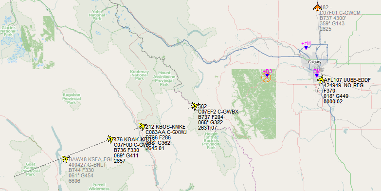
This image is from February 23. The aircraft with black text are being tracked by my setup, Grey text indicates data from another person's setup (shared over the net). I'm position B3, and there are several new sharers in Calgary area since this shot was taken. I'm particularly proud of the range I get with just the little indoor antenna stuck in my SW-facing windowsill. If I ever get the big DPD Productions antenna up, I might pick up the Mars rover. :)

The three planes coming at me from the SW are WestJet flights; their pilots key in their flight identifiers without their ICAO (WJA) or IATA (WS) codes, using only the flight number. Unfortunately other airlines also do this and somebody has entered an American carrier's flight data, which is why WestJet 212 is showing going from Boston to Milwaukee when it's clearly on approach to Calgary. I've since rectified that by deleting the existing route data in my PP database and telling the program not to accept shared route data.

You also see an Aeroflot flight and a British Airways plane, both of whom are going to overfly the Calgary region on the way to their respective destinations. The background map is from OpenStreetMap data automatically downloaded by PP.

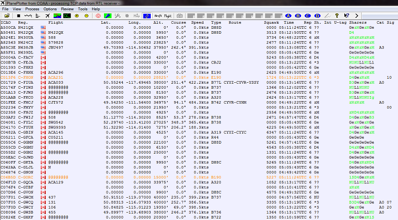
I don't typically keep the map view up as there's a ton of aircraft not sending position data. I get tons more info on the aircraft screen - here's one from right now.

2013-04-09_zps25b2e344.png


Excuse the text size, I shrunk it somewhat from my 1900x1200 screen.

From left to right the data is: Mode-S code, registration (mark/"tail number"), flag of country Mode-S belongs to, whatever is being transmitted in the "callsign" field, latitude and longitude, altitude, course, speed, aircraft type, route, transponder squawk, time of last signal received, sharer ID, last 5 sharers, aircraft category, and signal strength.

Theoretically all the ones with zeroes for lat and long should be candidates for multilateration (position fixes based on triangulation from several PP sharers), but none of them are actually plotting on my system. Either not enough of us are getting signals from them or something else is up.
 

kma371

QRT
Joined
Feb 20, 2001
Messages
6,204
hey jay how did you get the flags in there? I've never been able to figure that out.

are you using your own maps too?
 

Jay911

Silent Key (April 15th, 2023)
Feed Provider
Joined
Feb 15, 2002
Messages
9,378
Location
Bragg Creek, Alberta
hey jay how did you get the flags in there? I've never been able to figure that out.

are you using your own maps too?

There was a flag package download I found somewhere that helped me out. The flags are stored in C:\COAA\PlanePlotter\Chart files\countries, and there is a flags.txt file which I have stored in C:\Program Files (x86)\COAA\PlanePlotter\. That file has lines reading like:

Code:
A00000 AFFFFF C:\COAA\PlanePlotter\Chart files\countries\US.bmp
C00000 C3FFFF C:\COAA\PlanePlotter\Chart files\countries\CA.bmp

Of course, the corresponding US.bmp and CA.bmp files have to exist and are the flags of those countries. Then, in Options>Flags>Define country flags, point to that flags.txt file.

The blank spot to the right of the flags in the above screenshot is supposed to be company silhouettes/logos/"flags" but has never worked for me. It's supposed to be a similar setup.

The map shown above is OpenStreetMap data which you get by holding down right-shift while clicking on the map download button (to the left of the sharing button on the toolbar).
 

Jay911

Silent Key (April 15th, 2023)
Feed Provider
Joined
Feb 15, 2002
Messages
9,378
Location
Bragg Creek, Alberta
Save the GPX file (second hyperlink) from this URL to your chart directory (typically C:\COAA\PlanePlotter\chart files\). http://www.coaa.co.uk/sharerlocations.php

Then Options>Chart>GPX Overlay, define it, and enable it.

You have to manually download and save/move it into that folder periodically (say, every few days) if you want to keep it up to date. No need to restart PP - it will automatically update the screen when you replace the gpx file.

I presume you're lS since that one showed up not longer after you showed interest? :)
 

robertmac

Member
Premium Subscriber
Joined
Jun 6, 2005
Messages
2,298
Did this one make it to Alberta? Just west of Kalispell 0018 hours with track of 18'.
Airline: NASA
Flight: NASA747
From: PALMDALE, PALMDALE PROD FLT TEST INSTL AF PLT 42 (PMD)
To: PALMDALE, PALMDALE PROD FLT TEST INSTL AF PLT 42 (PMD)
Aircraft: Boeing 747SP-21 (B74S)
Reg: N747NA
Altitude: 40000 ft (12192 m)
Speed: 493 kt (913 km/h, 567 mph)
Track: 18°
Hex: AA0DB8
Squawk: 0000
Pos: 46.9511 / -116.4475
 

robertmac

Member
Premium Subscriber
Joined
Jun 6, 2005
Messages
2,298
Not sure this is unusual aircraft but just west of Calgary/Bragg Creek 2250. See an awful lot of planes headed to/from Ted Stevens.

Airline: China Airlines
Flight: CI5383
From: Houston, George Bush (IAH)
To: Anchorage, Ted Stevens (ANC)
Aircraft: Boeing 747-409F (SCD) (B744)
ETA: 07:57 UTC (in 03:05)
Reg: B-18711
Altitude: 36000 ft (10973 m)
Speed: 467 kt (865 km/h, 537 mph)
Track: 322°
Hex: 89911F
Squawk: 0000
Pos: 50.631 / -114.3844
 

mibzzer15

Member
Joined
Apr 14, 2009
Messages
394
Location
Fremont, CA
I dumped AirNav for several reasons - near 100% CPU use 24/7, a dissatisfactory program, and other varying issues. With PlanePlotter and an RTL-SDR, I pay a small fraction of what it cost to get the RadarBox up and running, and there's no yearly subscription fee either...

RTL-SDR? Software defined radio, I think you also said this was a small USB dongle? Can you explain this a little bit and where did you buy yours from?

After reading through this thread and a few others, I am getting very interested in this and am looking to possibly get something inexpensive setup for myself. I live in the SF bay area in CA so I am sure this would be able to catch a lot of planes.

Thanks.
 

Jay911

Silent Key (April 15th, 2023)
Feed Provider
Joined
Feb 15, 2002
Messages
9,378
Location
Bragg Creek, Alberta
RTL-SDR? Software defined radio, I think you also said this was a small USB dongle? Can you explain this a little bit and where did you buy yours from?

After reading through this thread and a few others, I am getting very interested in this and am looking to possibly get something inexpensive setup for myself. I live in the SF bay area in CA so I am sure this would be able to catch a lot of planes.

Thanks.

I originally bought some off eBay, but these ones on Amazon are reported to have better sensitivity for the kind of frequencies that this application (aircraft tracking) uses:

Amazon.com: NooElec TV28T v2 USB DVB-T & RTL-SDR Receiver, RTL2832U & R820T Tuner, MCX Input. Low-Cost Software Defined Radio Compatible with Many SDR Software Packages. R820T Tuner & ESD-Safe Antenna Input, Guaranteed: Everything Else

These are USB sticks originally intended to receive European/Asian digital TV signals from the air, but someone figured out how to get into them and make them tunable from about 64 MHz to 1700 MHz (at least the ones I am currently using - others have different frequency ranges).

If you look back in this thread, I reference PlanePlotter and the other little bits of software (particularly RTL1090, which receives the data off the SDR USB stick and feeds it to PlanePlotter).
 

mibzzer15

Member
Joined
Apr 14, 2009
Messages
394
Location
Fremont, CA
I originally bought some off eBay, but these ones on Amazon are reported to have better sensitivity for the kind of frequencies that this application (aircraft tracking) uses:

Amazon.com: NooElec TV28T v2 USB DVB-T & RTL-SDR Receiver, RTL2832U & R820T Tuner, MCX Input. Low-Cost Software Defined Radio Compatible with Many SDR Software Packages. R820T Tuner & ESD-Safe Antenna Input, Guaranteed: Everything Else

These are USB sticks originally intended to receive European/Asian digital TV signals from the air, but someone figured out how to get into them and make them tunable from about 64 MHz to 1700 MHz (at least the ones I am currently using - others have different frequency ranges).

If you look back in this thread, I reference PlanePlotter and the other little bits of software (particularly RTL1090, which receives the data off the SDR USB stick and feeds it to PlanePlotter).

Thank you Jay, I just ordered the dongle. Will let you know what happens when I get it in and try it out. Thanks.
 

robertmac

Member
Premium Subscriber
Joined
Jun 6, 2005
Messages
2,298
While working outside this afternoon, noted what looked like 3 Snowbird jets taking off on runway 16 and banking to the east at 1515 hours. Then at 1650 a CF-18 was landing on runway 34. Don't see any posting of these so wonder if anyone say them on their PlanePlotter? Wasn't monitoring anything this afternoon so did hear any strange call signs. Earlier in the day did hear of a plane landing with some problem but landed safely.
 

Jay911

Silent Key (April 15th, 2023)
Feed Provider
Joined
Feb 15, 2002
Messages
9,378
Location
Bragg Creek, Alberta
Your eyes didn't deceive you. There were 6 Snowbirds (at least) at Shell Aerocenter today around 1330, as well as a Buffalo Airways DC4 - silver with a giant white "16" on a green tail (N55CW) - most likely unrelated but I thought I'd mention it anyway.

It would appear none of them had Mode-S activated, or didn't fly into my receiver's airspace. The only Canforce aircraft I had today was a C130.
 

robertmac

Member
Premium Subscriber
Joined
Jun 6, 2005
Messages
2,298
The 3 I saw were a little high up and from underneath couldn't see any color. The 3 appeared to have taken off together as they were flying wing tip to wing tip. And looked like the Tutor jets they fly. Kind of thought they might be headed back to Moose Jaw. So glad my old eyes can still see. I did watch for a while to see if others took off but nothing. I could have easily missed earlier ones as they don't make near as much noise as the CF-18 made when landing and not much more than passenger jets taking off. I see the Snowbirds are scheduled to be in Airdrie and Lethbridge in July so will have to listen for them at that time.
 
Joined
Sep 16, 2012
Messages
51
Location
UK
On Wednesday Solar Impulse is expected to start its flight across the USA

Whilst it will be flying Mode S only , it will be possible to track it on PP
whenever its picked up by the mlat sectors.

On April 24th [ GMT] is was logged during its last test flight and located a
number of times by the Ca mlat sector.It climbed to 8300 feet during the
test

animation at..
http://i41.tinypic.com/2j5l51.gif

Full info about Solar Impulse here.....

http://www.solarimpulse.com/en/tag/Across-America

Regards

John

PlanePlotter Support
**PlanePlotter the first and only multilateration network software
for aviation enthusiasts.
PlanePlotter from COAA
 
Joined
Sep 16, 2012
Messages
51
Location
UK
Virgin Galactic

In the air today... A3DC2A N348MS made 45,600 feet at 1443 GMT
....not sure if it deployed the "sub orbiter" , or this was just a test.
The latter is N339SS , but not listed as Mode S
 
Status
Not open for further replies.
Top