New ERS Tier 3 system

INDaviation

ØÆS
Premium Subscriber
Joined
May 8, 2020
Messages
394
Location
The 317
I'm seeing a new Motorola DMR Tier 3 control channel on 451.009375. It's showing as site L10-7 with sites 12, 14, 15, 30, 32, and 33 as neighbors. This site is using color code 4, with the other ones using CC 1. Looks like the site numbers match up with the Con+ system as this may be it's replacement.

Here is the license for the system:

I haven't logged any talkgroups or voice activity yet, only the single control channel. As of now, the Con+ is still up and passing traffic.
The system is running RAS.
 

INDY72

Monitoring since 1982, using radios since 1991.
Premium Subscriber
Joined
Dec 18, 2002
Messages
14,850
Location
Indianapolis, IN
I noticed the Con+ system at the downtown site passing T3 data for a while the other day and thought I was going crazy LOL. I would also expect that new 800 to come online this summer too.
 

INDY72

Monitoring since 1982, using radios since 1991.
Premium Subscriber
Joined
Dec 18, 2002
Messages
14,850
Location
Indianapolis, IN
oh and have you logged an SysID for the T3 side yet? Any LCN's?
 

INDaviation

ØÆS
Premium Subscriber
Joined
May 8, 2020
Messages
394
Location
The 317
Sys ID is L10 I think, and DSD shows a ? in place of the LCN. I'll be monitoring this system closely over the next few weeks.
 

west-pac

Member
Joined
Nov 13, 2004
Messages
1,649
Sys ID is L10 I think, and DSD shows a ? in place of the LCN. I'll be monitoring this system closely over the next few weeks.
There was some talk about whether or not DSD+ was accurate when decoding T3 systems. When I received the NIPSCO system in northern Indiana I thought it was L10 or L11, either way, RR listed one, and DSD decoded the other. After checking just now, I see the the System ID isn't even listed; likely because of the discrepancy between different decoding softwares.

Also, hasn't that ERS 800 system been on-paper for years?
 

INDaviation

ØÆS
Premium Subscriber
Joined
May 8, 2020
Messages
394
Location
The 317
When I get home I can put the frequency in one of my scanners and see what I get, if anything.
 

INDY72

Monitoring since 1982, using radios since 1991.
Premium Subscriber
Joined
Dec 18, 2002
Messages
14,850
Location
Indianapolis, IN
There was some talk about whether or not DSD+ was accurate when decoding T3 systems. When I received the NIPSCO system in northern Indiana I thought it was L10 or L11, either way, RR listed one, and DSD decoded the other. After checking just now, I see the the System ID isn't even listed; likely because of the discrepancy between different decoding softwares.

Also, hasn't that ERS 800 system been on-paper for years?
The Indy 800 is not that old as far as licenses. It was approved right before COVID hit. And well we all know COVID slowed everything to basically an halt for 2 years. FCC Callsign WRFB802 (EMERGENCY RADIO SERVICE LLC) I was originally told this was primarily being done specifically for IU Health Lifeline. But things are pretty fluid these days.
 
Last edited by a moderator:

INDaviation

ØÆS
Premium Subscriber
Joined
May 8, 2020
Messages
394
Location
The 317
Alright, I went and put the system in my SDS100. Showing site 7, CC 4, Net ID A(?). Still no LCN.
 

venom6733

Member
Premium Subscriber
Joined
Feb 1, 2009
Messages
279
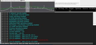
I know this is an old thread but I was wondering if anybody figured out what the L10 is? I was searching around and came across this CC on 451.7875 (which happens to be the same frequency for Anderson & Blufton's ERS-OCI Wireless TRBOconnect but not their Control Channels). Im in Delaware county and Im able to pick this up without an antenna on my rsp so it must be close.

Current Site L10-10
Neighbors are L10-26; CC=1
L10-11; CC=2033
L10-9; CC=2019
L10-14; CC=2007
L10.jpg
 

mtindor

OH/WV DB Admin
Database Admin
Joined
Dec 5, 2006
Messages
11,030
Location
Carroll Co OH / EN90LN
There was some talk about whether or not DSD+ was accurate when decoding T3 systems. When I received the NIPSCO system in northern Indiana I thought it was L10 or L11, either way, RR listed one, and DSD decoded the other. After checking just now, I see the the System ID isn't even listed; likely because of the discrepancy between different decoding softwares.

Also, hasn't that ERS 800 system been on-paper for years?
DSDPlus attempts to go further than any scanner does when figuring out Tier III systems. Depending upon the system, it can get some things incorrect. But a Uniden scanner can as well.

In this case, the system is a Motorola CAPMAX system.
  • Uniden scanner: displays proper info (but LCN finder may not find correct LCNs)
  • DSDPlus: displays proper info
  • SDRTrunk: displays proper info (under Decoder: DMR you would want to have Ignore CRC Errors enabled)

So if the system hasn't been added to the DB yet, it should be added as a Motorola CapMax system and you shouldn't run into any issues with differing data from different products being used to collect info.

Once the system is set up in the DB, you would search only for decimal 10 system ID. The L isn't part of the system ID but instead is an indicator of the network model (S=small, L=Large, H=Huge).

Mike
 

mtindor

OH/WV DB Admin
Database Admin
Joined
Dec 5, 2006
Messages
11,030
Location
Carroll Co OH / EN90LN
Alright, I went and put the system in my SDS100. Showing site 7, CC 4, Net ID A(?). Still no LCN.

Uniden displays the hex value of the network ; DSDPlus displays the decimal value. A = 10.
I'm seeing a new Motorola DMR Tier 3 control channel on 451.009375. It's showing as site L10-7 with sites 12, 14, 15, 30, 32, and 33 as neighbors. This site is using color code 4, with the other ones using CC 1. Looks like the site numbers match up with the Con+ system as this may be it's replacement.

Here is the license for the system:

I haven't logged any talkgroups or voice activity yet, only the single control channel. As of now, the Con+ is still up and passing traffic.
The system is running RAS.

Any chance you can post the LCNs associated with the neighbors on this site. DSDPlus displays those as:
L10-7 Neighbor: Site L10-12; CC=
L10-7 Neighbor: SiteL10-14; CC=
L10-7 Neighbor: SiteL10-15; CC=
L10-7 Neighbor: SiteL10-30; CC=
L10-7 Neighbor: SiteL10-32; CC=
L10-7 Neighbor: SiteL10-33; CC=
 

venom6733

Member
Premium Subscriber
Joined
Feb 1, 2009
Messages
279
@mtindor Ill leave it running for a few days and see if I hear something, so far I havent hear anything. Thanks for the reply (y)
 

west-pac

Member
Joined
Nov 13, 2004
Messages
1,649
This system is already in the RRDB, originally listed as System ID 11, with sites identified with Regions and Site numbers. For example: L11 3.4 may be the same as L10-7. The whole radio system is listed in the RRDB in the Uniden scanner/L11 Region.Site number format.

Which one is correct?..both, depending on whether you're looking at the system with a scanner; or with a computer. That's why I never tried to change it.


mtindor

OH/WV DB Admin
Database Admin
Joined
Dec 5, 2006
Messages
11,030
Location
Carroll Co OH / EN90LN
This system is already in the RRDB, originally listed as System ID 11, with sites identified with Regions and Site numbers. For example: L11 3.4 may be the same as L10-7. The whole radio system is listed in the RRDB in the Uniden scanner/L11 Region.Site number format.

Which one is correct?..both, depending on whether you're looking at the system with a scanner; or with a computer. That's why I never tried to change it.


Although I would like to answer you (and will in PM) I feel I shouldn't write my essay of a response in this thread since it's not relevant and would simply confuse anyone who was attempting to sleuth / document this system. I'll shoot you a PM if I'm not blocked :)

Mike
 

INDaviation

ØÆS
Premium Subscriber
Joined
May 8, 2020
Messages
394
Location
The 317
Uniden displays the hex value of the network ; DSDPlus displays the decimal value. A = 10.


Any chance you can post the LCNs associated with the neighbors on this site. DSDPlus displays those as:
L10-7 Neighbor: Site L10-12; CC=
L10-7 Neighbor: SiteL10-14; CC=
L10-7 Neighbor: SiteL10-15; CC=
L10-7 Neighbor: SiteL10-30; CC=
L10-7 Neighbor: SiteL10-32; CC=
L10-7 Neighbor: SiteL10-33; CC=
I haven't found any of those sites. Only the one here in Indianapolis. I don't even think this system is used yet. ERS's Connect+ system is still alive and well and full of activity. I expect the CapMax to come alive in the next couple years.
 

mtindor

OH/WV DB Admin
Database Admin
Joined
Dec 5, 2006
Messages
11,030
Location
Carroll Co OH / EN90LN
I haven't found any of those sites. Only the one here in Indianapolis. I don't even think this system is used yet. ERS's Connect+ system is still alive and well and full of activity. I expect the CapMax to come alive in the next couple years.

Understood, but based upon you reporting neighbors of Site 10.7, I was suspecting you used DSDPlus. And if you use DSDPlus and it lists the neighbors for that site, it also lists those lines in the EVent Log window like I indicated. An example as to what I'm referring to can be seen in @venom6733 post here: New ERS Tier 3 system

If you aren't using DSDPlus, then disregard my query. But if you do use DSDPlus, please try and get that information from the Event Log window the next time you monitor that site. That info is very useful about the neighbors and their associated CC= data.
 

INDaviation

ØÆS
Premium Subscriber
Joined
May 8, 2020
Messages
394
Location
The 317
I do use DSD and that's how I got the neighbor list. But, I didn't get that info in the event log. It only had the one freq that I was parked on and had a question mark in place of the LCN. I'm not sure the other sites are even turned on.

In the bigger scheme of things I'm really not that invested in finding the rest of the system until it starts being used regularly.
 

west-pac

Member
Joined
Nov 13, 2004
Messages
1,649
I know this is an old thread but I was wondering if anybody figured out what the L10 is? I was searching around and came across this CC on 451.7875 (which happens to be the same frequency for Anderson & Blufton's ERS-OCI Wireless TRBOconnect but not their Control Channels). Im in Delaware county and Im able to pick this up without an antenna on my rsp so it must be close.

Current Site L10-10
Neighbors are L10-26; CC=1
L10-11; CC=2033
L10-9; CC=2019
L10-14; CC=2007
View attachment 151985

That is ERS, on this license. The tower is on 26th St in Muncie.


The information you have on your screen matches the original non-T3 ERS system for the Muncie site (site 10).


You may need to reboot your setup.
 

west-pac

Member
Joined
Nov 13, 2004
Messages
1,649
Well sh*t. I needed to reboot as well. Now I'm seeing the T3 site on 451.7875. It appears to be the same info as the Con+ system.
 

Attachments

  • 20231126_115823.jpg
    20231126_115823.jpg
    201.9 KB · Views: 19
Top