As the title says, I have a DMR TIII system super close to me that has been operating on an expired license for two years. See more about that HERE. It is not in the RRDB so I thought I would do my best to get it documented. I wasn't sure the best place to post this - either here or in the DSD+ subforum. According to the FCC database, the callsign has four different physical locations all within a few miles of each other. I put them into a table below with their assigned frequencies.

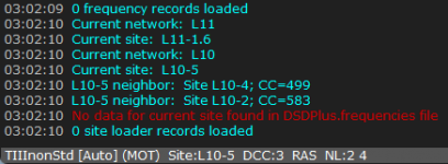
My goal is to get the correct physical site frequencies into their appropriate "sites" on Sentinel, then load into my SDS200 and to search for the LCNs. I've used DSD+ only slightly, but if that would be easier to use let me know. What would be the next step to get this mapped out correctly?
My goal is to get the correct physical site frequencies into their appropriate "sites" on Sentinel, then load into my SDS200 and to search for the LCNs. I've used DSD+ only slightly, but if that would be easier to use let me know. What would be the next step to get this mapped out correctly?