So you configured a rebroadcast server in VRS? The reason I ask I don't see it enabled in your VRS options photo in your post. There should be a line in the rebroadcast server box showing bites sent etc.

You are using an out of date browser. It may not display this or other websites correctly.
You should upgrade or use an alternative browser.
You should upgrade or use an alternative browser.
Calculating radio Horizon
- Thread starter davenlr
- Start date
- Status
- Not open for further replies.
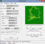
That's not bad at all, looks like you have a mountain or something to the west and south? Or planes didn't fly over there last night? Max distance 127.9 miles. So you are going to install a dpd for ads-b? That should help get you out to 160 miles. I've never had any hits above 200 miles 150 is about average. My plots look like a fat x because of mountains all around me and restricted airspace to the north. Today's max hit was 153 miles. Save the plot so you can compare antennas. Also wait for a really busy flying day like Sunday.
I am hoping. Here is the daytime plot. Its all mountainous to the west, except those long lobes toward Texas are looking right down Interstate 30, which is fairly hilly, but no major mountains. To my east, which is the direction I am trying to improve, it TOTALLY FLAT once I get 5 miles east of my current locations, but between me and the flat, its 550, or about 150' higher than my antenna. Same to the south.
Attachments

Those problems to the south and west are 30 miles away, the east problem is almost 50. It all depends on the altitude of the planes in those areas. You may not have normal flight routes in those empty areas?
Here's what I get today.
Last edited:
You are getting the Southwest planes. We have lots of those around here, but they arent showing up on my screen or my tracking/logo. Maybe have something wrong there. I just downloaded and installed the files from SBS, and copied all the logos into one directory. I notice all the Southwest Registrations are preceeded by a ~. I havent seen any with that on it.
Check your pm's
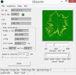
Got the DPD 1090Mhz antenna up today. Already noticing a big difference. The dead spots are still there, but extended about 30 miles farther out now, but actually was able to pick up a few planes over Texas at 200+ miles. Very well made antenna. I am not very familiar with N connectors. This antenna has a female N connector mounted on the end of a short pigtail, which I connected my LMR400 with male N connector to. Are these connectors waterproof, or will I need to enclose the connection in a waterproof box or tape it up good?
Ill post the plotter of the DPD antenna to compare with the 1/2 wave coaxial dipole antenna after a couple days run.
Thanks all (esp 737mech) for their help and links.
Ill post the plotter of the DPD antenna to compare with the 1/2 wave coaxial dipole antenna after a couple days run.
Thanks all (esp 737mech) for their help and links.
Those problems to the south and west are 30 miles away, the east problem is almost 50. It all depends on the altitude of the planes in those areas. You may not have normal flight routes in those empty areas?
I am right next to the Little Rock VOR, so most of the flights I see are heading directly to or away from me. There are others of course, but they mostly seem to be flying a route across the north part of the state.
What I dont understand about SBSPlotter, is I can watch a plane on the map flying across the south part of the state, at 130 miles, but on SBSPlotter, it doesnt aways show up. That area is blank, even though I just watched a plane fly across that area.
The east problem you say is at 50 miles, would probably be Crowleys Ridge, which rises from the flatlands at Mississippi river height, to over 450', and run the entire length of the state from north to south. Its about 50 or 60 miles away.
To the south, there is nothing that stands out, height wise at any distance, and to the west of course, are all mountains, some are in the 1100' range and pretty much cover the whole state from WSW to NW of me.
With the new antenna, I can see the planes pop up and drop off to the east, just as they fly over that ridge, so that makes sense. The other directions with nulls are probably just terrain. Im guessing I have about all the range I can get right now, short of finding a really low noise preamp to mount up at the antenna, and I doubt that would gain me much more. I do plan on raising the antenna another 10' to try to clear some trees in the yard, sometime soon. Just wanted to make sure I had enough coax to do that.
- Status
- Not open for further replies.
Similar threads
- Replies
- 22
- Views
- 1K
- Replies
- 18
- Views
- 1K