dbestfirefighter
Dozer
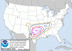
Day 2 Convective Outlook
Nws Storm Prediction Center Norman Ok
1259 Am Cdt Wed Apr 02 2008
Valid 031200z - 041200z
...there Is A Mdt Risk Of Svr Tstms Over Parts Of N Tx...ok And Wrn
Ar...
Combination Of Strengthening Deep Wind Field...increasing
Moisture/large Scale Ascent...and Daytime Heating Expected To Yield
An Environment Favorable For Sustained Supercells With Very Large
Hail...high Wind And Tornadoes Invof Sfc Wave And Associated Dry
Line And Warm/stationary Front Over Nw Tx And Wrn/srn Ok Thursday
Aftn.
It Remains Too Early To Comment Specifically On Mesoscale
Details...especially Given Likelihood For Elevated Warm Advection
Storms In Ok Early In The Day. But Overall Setup Should Result In A
Corridor Of Uncapped...very Unstable Air /sbcape Aoa 2500 J Per Kg/
Near Aforementioned Sfc Wave By Late Thursday Aftn. As The Wave
Develops Ese Toward The Red Rvr...expect At Least A Few Discrete
Supercells Will Evolve In The Increasingly Sheared Environment.
These Storms Likely Will Grow Upscale Through Thursday Night/early
Friday...with Severe Hail...high Wind And Possibly Isolated
Tornadoes Spreading Ewd/sewd Across The Remainder Of Ok/cntrl Tx And
Into Ar And The Lwr Tn/oh Vlys Early Friday. Additional
Storms/clusters May Also Form Thursday Night Through Early Friday
Across S Cntrl Tx As Increasing Uvv/low Level Convergence Strengthen
Along Trailing Dry Line.