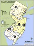
NJ State Police Patrol areas Troop B

Status
Not open for further replies.

richee2000

Communications Professional
Joined
Sep 29, 2014
Messages
2,259
Location
Sea Bright NJ, East Hanover NJ, Basking Ridge NJ
trying to find a map with the specific patrol areas of these Comms for NJSP Troop B:
that show each Area, 2 comm , 3 comm, 4 comm, 5 comm


35696 B 2-COMM Sussex 2-COMM Dispatch - Sussex
35728 B 3-COMM West 3-COMM Dispatch - West
35760 B 4-COMM North 4-COMM Dispatch - North
35792 B 5-COMM South 5-COMM Dispatch - South
 

W2SJW

Senior Member
Database Admin
Joined
Nov 22, 2001
Messages
3,265
Location
Northwest NJ
Sorry for the wall of text - some of this might be a little outdated, but there is no map per-se...

North (Troop B) Road Stations
Troop Headquarters: Totowa Sub-Station
Dispatch Group: ODU – North

2-Comm Dispatch (Northwest Stations)

Sussex Station Andover Twp.
Branchville Boro.
Frankford Twp.
Fredon Twp.
Green Twp.
Hampton Twp.
Lafayette Twp.
Montague Twp.
Sandyston Twp.
Sussex Boro.
Walpack Twp.
Wantage Twp.

3-Comm Dispatch (West Stations)

Hope Station
Hardwick Twp.
I-80
Franklin Twp.
Liberty Twp.
White Twp.

4-Comm Dispatch (East Stations)

Netcong Station
I-80
I-287 (MP 40.3 to MP 53.9)
Totowa Sub-Station I-80 (MP 40.3 to MP 68.3)
I-280 (MP 0.0 to MP 18.0)
I-287 (MP 53.9 to MP 67.5)
RT 24, RT 124 Various

5-Comm Dispatch (South Stations)

Perryville Station I-78 (MP 0.0 to MP 25.5)
Somerville Station
I-78 (MP 25.5 to NJTP)
I-95
I-287 (MP 14.0 to MP 40.3)
RT 24, RT 124 Various
 

W2SJW

Senior Member
Database Admin
Joined
Nov 22, 2001
Messages
3,265
Location
Northwest NJ
I THINK so, but don't quote me on it! Not quite sure what happened after they closed Edison Station.
 

RadioDitch

Field Operations Member
Premium Subscriber
Joined
Jan 24, 2010
Messages
3,090
Location
Wandering Around
My troop guide says Troop B only covers South through Somerset County. It says Middlesex County is Troop C.

Sent from my SM-G955U using Tapatalk

Somerville Station on B2-05 South.
 

Attachments

  • troopareas_011014-490.jpg
    troopareas_011014-490.jpg
    181.1 KB · Views: 554

W2SJW

Senior Member
Database Admin
Joined
Nov 22, 2001
Messages
3,265
Location
Northwest NJ
I wish the map would show the sector breakdown within each troop.

A map like that has to exist, but probably only inside the NJSP for official use.
 

RadioDitch

Field Operations Member
Premium Subscriber
Joined
Jan 24, 2010
Messages
3,090
Location
Wandering Around
This is the cheat sheet i've been working on if anyone has any input please feel free to PM me. I broke it down by Highways & Areas Covered. I dont have much of Troop A bc i dont get them here but Troop B is full and most of C is in there as well.

https://www.dropbox.com/s/dy6piz34sz67itr/NJSP-Comms-Cheatsheet.xlsx?dl=0

Several corrections to your cheat sheet:

All toll roads are patrolled by Troop D, Troop E was disbanded. Troop D is it's own troop, not under the command of B/C/A.

There is no Sayreville Barracks, that is the NJTA Headquarters. No road patrols are stationed there.

Troop D Newark Barracks patrols the NJTP (incl. Hudson Extension) from Interchange 12 in Carteret north rather than Interchange 14/I-78.

Both Bass River and Holmdel are Troop D and would fall in Troop C's mapped area rather than Troop A. Holmdel is in Monmouth County, Bass River is in Burlington County. Troop A has no responsibilities in Ocean or that part of Burlington.

For Troop A you're missing ACE patrols from Hammonton Station.
 
Last edited:

RadioDitch

Field Operations Member
Premium Subscriber
Joined
Jan 24, 2010
Messages
3,090
Location
Wandering Around
Troop D

Turnpike:
1-Comm South - Moorestown Station (DMB-Interchange 7A)
2-Comm Central - Cranbury Barracks (Interchange 7A-Interchange 12)
3-Comm North - Newark Station (Interchange 12-GWB)

Parkway:
1-Comm Central - Holmdel Barracks (Mile 89-Mile 131.1)
2-Comm North - Bloomfield Station (Mile 131.1-State Line)
3-Comm South - Bass RIver Station (Mile 0-Mile 89)

---------------------------------------------------------------------------------------------------
Troop B: 5-Comm Dispatch (South Stations) (TG B2-05)

Perryville Station: I-78 (Mile 0.0 to Mile 25.5) (Includes CVE at Bloomsbury scales)
Somerville Station: I-78 (Mile 25.5-NJTP) / I-287 (Mile 0.0-Mile 40.3) / NJ-24* (Inclusive: End to End)

*Somerville Station has a joint patrol agreement with Florham Park Police for NJ-24.
 
Last edited:

APX8000

Sarcastic Member
Premium Subscriber
Joined
Nov 23, 2004
Messages
4,315
Location
AES-256 secured
Troop D

Turnpike:
1-Comm South - Moorestown Station (DMB-Interchange 7A)
2-Comm Central - Cranbury Barracks (Interchange 7A-Interchange 12)
3-Comm North - Newark Station (Interchange 12-GWB)

Parkway:
1-Comm Central - Holmdel Barracks (Mile 89-Mile 131.1)
2-Comm North - Bloomfield Station (Mile 131.1-State Line)
3-Comm South - Bass RIver Station (Mile 0-Mile 89)

---------------------------------------------------------------------------------------------------
Troop B: 5-Comm Dispatch (South Stations) (TG B2-05)

Perryville Station: I-78 (Mile 0.0 to Mile 25.5) (Includes CVE at Bloomsbury scales)
Somerville Station: I-78 (Mile 25.5-NJTP) / I-287 (Mile 0.0-Mile 40.3) / NJ-24* (Inclusive: End to End)

*Somerville Station has a joint patrol agreement with Florham Park Police for NJ-24.


I have to check my laptop, should have a breakdown of Troop B (Totowa vs Netcong) coverage area.

But I believe Netcong covers 24 from I-287 to MM 6 and then Somerville from MM 6 to I-78.

As far as Totowa, they cover 80 from the GWB up to 287 and then north to the NYS line as well as 289. Netcong covers 80 west of 287 and a portion of 287 and 24 down to where Somerville takes over. I’ll get the exact MM’s.


Sent from my iPhone using Tapatalk
 
Status
Not open for further replies.
Top