Scanning while on Interstate 95- multiple states

Status
Not open for further replies.

garys

Member
Premium Subscriber
Joined
Jun 13, 2002
Messages
6,429
Location
Texas
Without a digital trunking scanner you are out of luck OP. Maine P25 trunked, NH LET conventional, MA analog trunked, RI P25 trunked, CT P25 Phase 2, NY analog VHF, NJ analog trunk, PA encrypted, and so on.

I recently took a trip to SC, but not along the coast. I used my own programming for MA and CT, but once I hit the NY state line, I used GPS and he RRDB all the way through NY, PA, MD, WV, VA,NC, and SC.

While it's not as good as building your own systems for areas you are familiar with, that combination is great for traveling through areas.

I recommend upgrading to a P25 capable scanner with GPS.
 

TailGator911

Silent Key/KF4ANC
Joined
Feb 12, 2005
Messages
2,687
Location
Fairborn, OH
I have tried and tested both ways - an SDS200 scanner on gps, and another - pre-programmed - on a lengthy trip in my RV. The gps is instantaneous and I know it's a good way to move along without having to actually touch the scanner, but I did not like the fact that I never knew who I was listening to, when it switched agencies, and if any particular transmission was close to me at all. My other SDS200 was pre-programmed by me before the trip. Took me 3 weeks of tweaking and twerking as I coordinated my travels and stops and overnight camping locations using mile markers and the RRDB and making Favorite lists to coincide with my locations. Even edited alpha-tags to my liking. Is it tedious? You bet. Is it time consuming? Absolutely. Is it fun? Only if you're an old geek like me lol. Was it worth it? Worth every minute and then some. Have to say, I love the old school way, but I ran both scanners together and had a blast the whole trip comparing them. Doesn't take much to entertain this old man!
 

jonwienke

More Info Coming Soon!
Joined
Jul 18, 2014
Messages
13,409
Location
VA
I prefer GPS, as I don't spend a lot of time looking at the scanner display while driving, and prefer not to have to play with the keypad while driving, either, for safety reasons. But in must cases, I've found the scanner display reasonably informative, except in areas where I can pick up 4 states simultaneously, and it's not necessarily clear at first glance which "State Police" I'm listening to. But those situations are the exception rather than the rule.
 

KK4JUG

Member
Premium Subscriber
Joined
Dec 13, 2014
Messages
4,520
Location
GA
TailGator911, I do a lot of the same stuff. I traveled a lot before we were "blessed" with Covid-19, I used to do a lot of the same things, although I let the RR database and GPS handle the scanning.

I also specially programmed the ham radio with repeater freqs (2m & .70m only) along the route. I used RepeaterBook for most of the info. It's not great but it's better than nothing. I even printed out DeLorme maps in case the highway GPS got screwed up. Can't do that now. Garmin bought DeLorme and nobody does maps anymore anyway. (Before TomTom and the others, I actually used a DeLorme mapping/GPS program on the laptop. I had that bright yellow satellite antenna on the dash. It worked very well but working with the laptop was a bit cumbersome.)

I'll celebrate number 78 next month and you're right: planning is part of the fun when making a long trip.
 

TailGator911

Silent Key/KF4ANC
Joined
Feb 12, 2005
Messages
2,687
Location
Fairborn, OH
I actually used a DeLorme mapping/GPS program on the laptop. I had that bright yellow satellite antenna on the dash. It worked very well but working with the laptop was a bit cumbersome.)

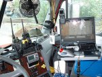
When I drove for Crete (CCC) I also used the DeLorme gps and a laptop - I went to the DeLorme forums and met a guy in there that did custom plugins for commercial vehicles and he gave them to people free of charge. I thought it was fantastic until the program put me into tight spots such as a 12 5' overpass and a 10' pedestrian bridge. Had to back up 3 miles with a police escort on the Cleveland Lake Erie waterfont who wrote me a $250 ticket for his inconvenience. Never trusted those plugins again lol. That was embarrassing. I really liked the DeLorme maps, too. This was my setup in a Freightliner Century Class at Crete. This pic has DeLorme on my laptop screen.

rigstuff.jpg
 

KK4JUG

Member
Premium Subscriber
Joined
Dec 13, 2014
Messages
4,520
Location
GA
When I drove for Crete (CCC) I also used the DeLorme gps and a laptop - I went to the DeLorme forums and met a guy in there that did custom plugins for commercial vehicles and he gave them to people free of charge. I thought it was fantastic until the program put me into tight spots such as a 12 5' overpass and a 10' pedestrian bridge. Had to back up 3 miles with a police escort on the Cleveland Lake Erie waterfont who wrote me a $250 ticket for his inconvenience. Never trusted those plugins again lol. That was embarrassing. I really liked the DeLorme maps, too. This was my setup in a Freightliner Century Class at Crete. This pic has DeLorme on my laptop screen.

View attachment 100924
Yeah...the good ole days.
 
Status
Not open for further replies.
Top