I have not dabbled in this area enough to understand much other than setting up software available for decoding APT. The only question is reading elevation and azimuth to determine when a satellite will be directly or nearly directly overhead. I can't do decodes from weather satellites just barely above the horizon. Like I said, I really need them to be overhead even if it takes a week.
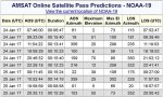
In this image I need to know if elevation column can tell me the highest point in the sky. Are higher numbers better?
In this image I need to know if elevation column can tell me the highest point in the sky. Are higher numbers better?