Cleveland National Forest New Forest Net

ecps92

Member
Joined
Jul 8, 2002
Messages
14,815
Location
Taxachusetts
Before the USFS [Public] on-line repeater map got disabled, I was able to download [KML - Google Earth] the Repeater sites
if anyone thinks this might be of value, I can upload it.
 

Teotwaki

Member
Joined
Aug 3, 2008
Messages
549
Location
SoCal
Before the USFS [Public] on-line repeater map got disabled, I was able to download [KML - Google Earth] the Repeater sites
if anyone thinks this might be of value, I can upload it.

That would be great information to have! Please do share.
 

ecps92

Member
Joined
Jul 8, 2002
Messages
14,815
Location
Taxachusetts
Let us see how well this uploads as a zip file
For those who do not have it, you will need Google Earth

Thought I had the file at work... but can't find it, will upload from home later
 

Attachments

  • Cleveland National Forest.zip
    19.3 KB · Views: 31

Teotwaki

Member
Joined
Aug 3, 2008
Messages
549
Location
SoCal
Interesting that there's nothing visible at Sitton Peak.


It is a 10 mile round trip hike from Ortega Highway to the geographic feature called Sitton Peak

IMG_0350.jpg


This may be another "Pine Cove". Just today I heard a number of CNF 300 series engines identifying using Tone 12 which is supposed to be what CNF calls "Sitton Peak" in their tone plan.

There is a radio site above Blue Jay campground that has a single tower with antennas.

33°39'12.3"N 117°26'44.6"W

It is about 5 miles north of Sitton Peak
 

krazybob

Member
Joined
Oct 26, 2003
Messages
481
Location
Lake Arrowhead, Southern California
To get this to work on your Android cell phone there's a three-step process.

1. Extract the zip file provided.
2. Start Google Earth for Android and go to my places.
3. Import the kmz file.

I already have these sites in my sight propagation and virtual mapping software but it's sure nice to have handy on a cell phone.

Sent from my SM-G965U using Tapatalk
 

krazybob

Member
Joined
Oct 26, 2003
Messages
481
Location
Lake Arrowhead, Southern California
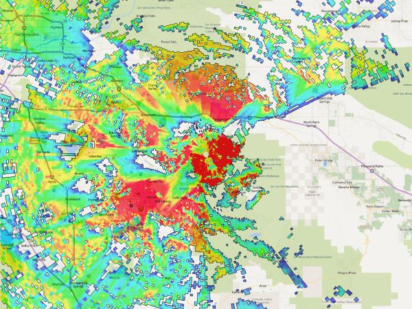
For those interested, this is the 5-watt HT coverage plotted from the peak located at 33.842167 , -116.824133. The peak has some coverage but the issue of course is the ability to copy units down at the bottom of a canyon.

ranger-ht-coverage.jpg
Sheez. Editing at its best. NOT! This is Ranger Peak and shows why the San Jacinto Mountain Range has multiple sites used by the Forest Service.
 

zz0468

QRT
Banned
Joined
Feb 6, 2007
Messages
6,034
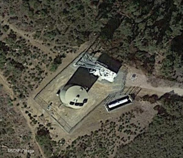
The coordinates you posted correspond to a site called "Ortega" in the KMZ file posted earlier, so I'm not sure what's what. The actual "Sitton Peak" is obviously not the location of the CNF repeater.

The "Ortega" site is, I believe, a Riverside County PSEC site. The curious thing is, the KMZ file shows both Ortega and Sitton.


It is a 10 mile round trip hike from Ortega Highway to the geographic feature called Sitton Peak

This may be another "Pine Cove". Just today I heard a number of CNF 300 series engines identifying using Tone 12 which is supposed to be what CNF calls "Sitton Peak" in their tone plan.

There is a radio site above Blue Jay campground that has a single tower with antennas.

33°39'12.3"N 117°26'44.6"W

It is about 5 miles north of Sitton Peak
 

Teotwaki

Member
Joined
Aug 3, 2008
Messages
549
Location
SoCal
The coordinates you posted correspond to a site called "Ortega" in the KMZ file posted earlier, so I'm not sure what's what. The actual "Sitton Peak" is obviously not the location of the CNF repeater.

The "Ortega" site is, I believe, a Riverside County PSEC site. The curious thing is, the KMZ file shows both Ortega and Sitton.

Very interesting! At my house I can receive very well stations that select the "Sitton Peak" tone. I've tried scanning around the satellite image of the area to see if I can spot anything but maybe I'll go out along Ortega Highway with a beam and do a little RDF'ing if the riddle is not solved in the next few days.
 

Teotwaki

Member
Joined
Aug 3, 2008
Messages
549
Location
SoCal
The coordinates you posted correspond to a site called "Ortega" in the KMZ file posted earlier, so I'm not sure what's what. The actual "Sitton Peak" is obviously not the location of the CNF repeater.

The "Ortega" site is, I believe, a Riverside County PSEC site. The curious thing is, the KMZ file shows both Ortega and Sitton.


In a search for info on Sitton Peak I found a 2009 USFS initial planning blurb or "Proposed Action" for a repeater

Schedule Of Proposed Action - 01/01/2009 to 03/31/2009 - Cleveland National Forest

Description: The Forest proposes to install a Forest Service radio repeater at Sitton Peak T7S, R5W, Sec 6.
Location: UNIT - Trabuco Ranger District. STATE - California. COUNTY - Riverside. LEGAL - T7S, R5W, Sec 6. Sitton Peak.

The legal description translates to:

Section S6 T7S R5W
Meridian San Bernardino
State California
County Riverside
COMTRS 33S07S05W06

Centroid33.5881397, -117.4417639
Corners
NW33.5979233, -117.4503469
NE33.5982286, -117.4332031
SE33.5783012, -117.4330961
SW33.5781941, -117.4504689


The centroid shows something rectangular along the hiking trail but I don't think it is a repeater as I would expect some solar panels.

33°35'17.6"N 117°26'29.9"W

In the image there is something white and sort of pole shaped down and left about 40 feet away
 

zz0468

QRT
Banned
Joined
Feb 6, 2007
Messages
6,034
That could possibly be it. Federal agencies are known to put small solar powered repeaters up to get coverage where it's needed. Helicopter only access, mule access, etc. aren't unheard of.


In a search for info on Sitton Peak I found a 2009 USFS initial planning blurb or "Proposed Action" for a repeater

The centroid shows something rectangular along the hiking trail but I don't think it is a repeater as I would expect some solar panels.

33°35'17.6"N 117°26'29.9"W
 

zz0468

QRT
Banned
Joined
Feb 6, 2007
Messages
6,034
That thing in the road just north of the tank looks like a ground mounted transformer protected with bollards. Power in sensitive areas is frequently brought in under an existing or new road.

Pretty sure that's a PSEC site.

Ortega has a 500 gallon propane tank. That might suggest why there are no solar panels. Just a thought.
 

Teotwaki

Member
Joined
Aug 3, 2008
Messages
549
Location
SoCal
Ortega has a 500 gallon propane tank. That might suggest why there are no solar panels. Just a thought.

I was very specifically referring to the Sitton Peak locale as noted in my post, not the site by Blue Jay campground. I have driven to the one by Blue Jay which has commercial power.
 

ecps92

Member
Joined
Jul 8, 2002
Messages
14,815
Location
Taxachusetts
Try this in Google Earth, looks like there is buildings and antennas [more to the west of your location]
Lat 33.587222
Lon -117.446111

Had to get close as it looks like Foot/Mule only access :)
Interesting that there's nothing visible at Sitton Peak.
In a search for info on Sitton Peak I found a 2009 USFS initial planning blurb or "Proposed Action" for a repeater

Schedule Of Proposed Action - 01/01/2009 to 03/31/2009 - Cleveland National Forest

Description: The Forest proposes to install a Forest Service radio repeater at Sitton Peak T7S, R5W, Sec 6.
Location: UNIT - Trabuco Ranger District. STATE - California. COUNTY - Riverside. LEGAL - T7S, R5W, Sec 6. Sitton Peak.

The legal description translates to:

Section S6 T7S R5W
Meridian San Bernardino
State California
County Riverside
COMTRS 33S07S05W06

Centroid33.5881397, -117.4417639
Corners
NW33.5979233, -117.4503469
NE33.5982286, -117.4332031
SE33.5783012, -117.4330961
SW33.5781941, -117.4504689


The centroid shows something rectangular along the hiking trail but I don't think it is a repeater as I would expect some solar panels.

33°35'17.6"N 117°26'29.9"W

In the image there is something white and sort of pole shaped down and left about 40 feet away
 
Top