Cleveland National Forest New Forest Net

Kingscup

Member
Feed Provider
Joined
Jun 1, 2006
Messages
620
[size=+2]

Here's a treat for those that chose to read this far.
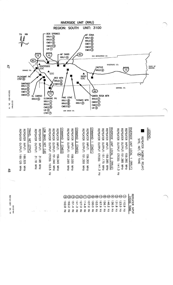
riversidecdf-600.jpg

This is out of date by at least several years.
 

zz0468

QRT
Banned
Joined
Feb 6, 2007
Messages
6,034
This site information is correct.

Lat/Long given for these repeater sites can be pasted into Google Maps, switch to satellite view and zoom in

Ranger Peak (VERIFIED - former AT&T Microwave site) off of Forest Service Road 4S05 33°50'31.4"N 116°49'26.7"W
This site is S/W of highway 243

Pine Cove/Marion Ridge/Rocky Point 33°45'54.0"N 116°43'56.2"W and is located 7.5 miles SSE of Ranger Peak
It is at roughly 24400 Rocky Point Rd, Idyllwild, CA 92549 and is approximately 2300 feet NNE of Riverside County Fire Dept. Station 23 in Pine Cove
 

prcguy

Member
Premium Subscriber
Joined
Jun 30, 2006
Messages
16,677
Location
So Cal - Richardson, TX - Tewksbury, MA
Well I'll at least say thank you to Bob for any information presented so far. I will also say from my personal experience, you probably wont find anyone as knowledgeable on So Cal repeater site locations than teotwaki.
 

PaulNDaOC

Member
Joined
Mar 8, 2009
Messages
598
OK Bryan - Paul,

This is not worth arguing about. Two units on simplex in Holcomb Valley, which is an area that you folks in OC cannot hear, does not put you in a position to determine what I heard and what flashed across my radio. I live on the ridge directly above Holcomb Valley.

I understand completely that just because the requirements say that the radio be compliant does not mean it's the operational. However, given the fact that San Bernardino County Sheriff is now 100% encrypted it would not surprise me that Forest Service LE are also beginning to use encryption. Unless one of you actually works in the Comm Center down on Tippecanoe none of you including me are in a position to determine one way or another.

I have a very detailed antenna system half of which cannot be seen in this picture. The other half includes dual phased yagi's on a rotor tuned for the Forest Service. I have a commercial antenna up for each band. I use yagi's when needed. I can hear LAPD rovers on simplex usually full quieting.

What wasted time when we could be communicating in a positive manner about a hobby we share instead of cheap ship pot shots from a handful of you.

sbnantennas
I would agree fully with Bob on this. The P25 requirement may be for the sole purpose of being able to access local agencies to coordinate calls, officer needs help,,etc..
 

PaulNDaOC

Member
Joined
Mar 8, 2009
Messages
598
Thank you! So there definitely will not be a LEO repeater at Mountain Center.

Jim
Orange County, CA
Just because you do not know a site known as 'Mountain Center' does not mean it does not exist as users may simply be calling it that because it's the best site to get into that location, or is on a peak nearby. A user identification does not mean its the official mailing address or name on the deed. Use a little flexibilty.
 

Teotwaki

Member
Joined
Aug 3, 2008
Messages
578
Location
SoCal
Just because you do not know a site known as 'Mountain Center' does not mean it does not exist as users may simply be calling it that because it's the best site to get into that location, or is on a peak nearby. A user identification does not mean its the official mailing address or name on the deed. Use a little flexibilty.

It might be a good idea to read all of the details to see who said what because it started with Crazy Bob making an incorrect iron-clad blanket statement that "here in the San Bernardino Mountain Forest they have switched over to p25 encrypted for LEOs already". It was only after pointed questioning and comments from several members that his mistaken claim morphed into a story of "...two units on simplex in Holcomb Valley"

Crazy Bob also incorrectly claimed "....LEO repeater on Santiago, Mountain Center, Elsinore Peak and Strawberry Peak"
and that lead to a number of questions about the accuracy of his statement and that only upset him more..

A little "flexibility"?? LOL. I think I was clearly open to correct information when I responded "What site is "Mountain Center"? I am drawing a blank so I either don't know that name or know the mountain peak by a different name. What other repeaters are there?? " I never said it didn't exist to Crazy Bob but later member Z0468 corrected him. Mountain Center is a small urban center of that area near Idyllwild as far as anyone can see and does not host a radio site of its own. As I noted before the physical site is on Rocky Point Road.

I simply asked for clarification and Crazy Bob threw a hissy fit and penned a number of ginormous font diatribes that included more mistakes and offered no flexibility. He went on to completely mix up Pine Cove, Ranger Peak, Marion Ridge, Mountain Center and Thomas Mountain into one fantastic furball, even changing the name to "Mountain Homes".

"Your guess as to what is referred to as Mountain Homes are incorrect. That antenna site is called Idyllwild (Thomas Mtn.p) and is on Rocky Point. The Pine Cove site has a commercial name of Ranger."

I've actually been very flexible and willing to discuss things but Crazy Bob is all about going into a rage and yelling about blocking users, banning them from some Teamspeak server and saying "Your combined arrogance and desire to be abusive and dismissive to me all the time show that you are simply internet bullies."

So please go lecture Crazy Bob about flexibility and for me I would like statements with accuracy and some sort of proof so I will know how to correct any of my information that has mistakes.
 

krazybob

Member
Joined
Oct 26, 2003
Messages
481
Location
Lake Arrowhead, Southern California
If you know it's wrong then cite your source. I actually scanned in my source and posted it. Now Teotwaki wants to argue with Paul. Do you notice a theme here? I have presented information directly out of U.S. Forest Service communications manuals and now you want to refer to me as "crazy." Grow up.

The specific problem I have with you, ZZ, you quote in sections and then say it's wrong but don't say what the correct information is. You stalk me from topic group to topic group and always make sure to insert comments attempting to state that I'm wrong but seldom give anything of technical value. I was a private pilot and could be posting in the aircraft section and you'd still tell me I was wrong. You are harassing me. IT STOPS NOW.

Before I go further let me compliment a user that stated that he monitored Forest Service LEOs on a frequency not allocated to them. It was simplex. I told you that they used numerous "discrete frequencies." You didn't believe me. Now one of you has monitored them doing just that. Do you believe him?

Let me begin with the fact that the Forest Service system is fully capable of simulcast repeater operation. But they do not use it that way. That would require the use a common tone at each site. They would use tone 8. It states it in the handbook. I stated that they are normally in manual select mode. "San Bernardino, Engine 57 on tone 5..." In fact, in the San Bernardino's they are normally on the output, otherwise known as talk-around. It is not common for them to be directly on the repeater. I don't usually monitor CNF but I can just as I can monitor MVU.

If you know anything about simulcast,
you know that there is overlapping coverage area in which signals that produce a wah wah wah sound. When they are slightly out of phase it's even more pronounced. How do I know? Because I run numerous repeaters that are in simulcast mode. How many do you run?

Do you know what a Spectra-Tac voter is? The Spectra-TAC Total Area Coverage Comparator is a nice device. It has a status tone as a base reference. Receive sites are linked and their signal to noise ratio is evaluated in real time and the best signal is chosen. There are new VoIP adapters called RTCMs that can take a Raspberry Pi and make it amazingly simple to build a very large network of voted repeaters. Or you can use one "alligator repeater" (big mouth) and multiple voted receive only sites.

They do not use tone select transmitter steering. If they did the dispatcher would not tell them to come up on a specific tone or they would not tell the dispatcher the time that they are on. Unless know the area that they are in and use that tone. When they change tones it comes in on the dispatchers console and they press the transmitter button next to it. Or they press Select and use the large transmit button on the Centracom. You'll tell me I'm wrong but you won't tell me how. That means you're speculating.

My antennas are located at almost 6400 feet and I can hear things in San Diego on simplex on Cal Fire that those of you with a discones at ground level could only dream of. That means that if two transmitters key up at the same time, which they would not do on tone select transmitter steering which would steer the signal to one transmitter based on the voted receive of the station calling, I can often hear it. You write that you weren't sure if they even use voting. You aren't sure but I'm wrong? How then would transmitter steering work?

Transmitter steering works based on a voted signal that tells the system which site to steer to automatically. The Forest Service radio system like the Cal Fire radio system is based on a honeycomb network of transceiver sites. They can operate in repeater mode, simulcast mode, and talk-around. Their normal mode is talk around.

CHP uses transmitter steering. It's specifically uses voting. The CHP officers don't manually change the tone. The system automatically votes which receiver has the best signal to noise ratio and steers the transmitter closest to the officer on the assumption that if he's best heard coming in on a particular receive site he will best hear the dispatcher on the same location. I can be listening to Santa Ana in particular and they are loud and clear. Suddenly they get a unit down south of Loma Ridge on the south side of the Santiago mountain range and I can barely hear them. That's transmitter steering. Fully automated transmitter steering.

Hearing simulcast sites is actually the curse of living at this altitude. When two transmitters key up it sometimes makes the signal difficult to copy. I could send them a note that they would ignore but they would need to transmit four times stronger in order for the capture effect to take over or I could only hear one of the two. This is one reason I have dual-phased yagi's on a rotor. I have one for Cal Fire as well because they often times will assign the same CMD channel on two incidents and I can hear both of them from my location on an omnidirectional antenna. I need to use the phased yagi's to null out one or the other. I know this both as an extra class amateur radio operator of over 40 years as well as on public safety. I can put together over 20 internet radio feeds using commercial antennas and hardline as well as operate multiple phased repeater sites on amateur radio but as far as you are concerned I know nothing.

The reference to "we" is a smartphone speech-to-text error that I didn't catch. My smart phone is stupid. I am not a member of the Forest Service. Too much time had passed and I was not able to edit the message and correct it.

I did not say Ranger Peak. I said Ranger. That is the FCC name. It is a 101 foot self supporting tower at 5085 ft ASL. It is 6 miles Southeast of Banning. It is Northwest of the Vista Grande Forest Service fire station.

I also specifically said Idyllwild. It is on a 75-foot tower at 6,573 ft ASL and is located at 24400 Rocky Point Road. It is not in downtown Idyllwild. I never said it was. This is the specific FCC site name. It is actually located near Pine Cove Park regardless of its FCC site name.

The accurate name is Little Thomas Mountain and it is due south of Lake Hemet as you accurately stated. It is just north of the intersection of NF-5 S15. Most of you didn't have this detail until I provided it to you directly out of the Forest Service radio handbook. You don't know what I'm not posting. But yet you argue.

We haven't even spoken of Tahquitz, which is at the northern edge of the San Bernardino Mountains near San Jacinto and I'd love to have a repeater on that mountain. The purpose of these locations that seemingly are close to one another is because of the topography. When fighting a fire firefighters are on handhelds. They are Bendix King GPH models with bush antennas and an orange battery pack. They're 5-watt radios. FEDCOM needs to be able to hear them down in the canyons whenever possible. This is why sites may appear to be geographically close to one another. But their topography does not lend itself to effective radio communications.

I'm not doing this argument back and forth anymore.

You take somebody with knowledge and access and reduce it to this. It makes you power users seemed more relevant with your 6000 posts that you think mean more than somebody with 400. I'd post more and participate more if I were not constantly attacked. And always by the same people. Why is that? Why is it you follow me from one topic group to another and always post contradictory information that you think I'm incorrect on? You don't know by your own words but you think. You take the fun out of monitoring. Here's the thing. If I don't know something or if I am mistaken on something I will own it. I don't know everything! But there's a lot of things I do know. By the way, the last Cal Fire radio plan was put out in 2016. Nothing has really changed.

If there's anything else that you'd like to knit pick apart maybe you should do it off the group because I'm sure the group is tired of reading this. Thank you Paul for noting that they may be transitioning to P25 because their civilian counterparts have done so. You also noted correctly that when they refer to something like Mountain Center it's often times because it is a geographic location that somebody can easily find on a map. They were required to use the Department of Interior purchasing contract for their new radios. FSH 6309.32, Section 4g13, FSH 6609.14, 20, and FSM 6641.1. It was easier than developing their own RFQ's based on their own specifications that essentially match the same as BLM.

Also Paul, let me congratulate you on a deliberate trap I set. CNF is not dispatched by San Bernardino. You are absolutely correct that it is dispatched by San Diego. Nobody caught that except you. I was waiting for what are the self-professed experts to catch it and blow it up. I deliberately did not include ANF which is dispatched out of Arcadia. I grew up in Arcadia.

I will give Jim credit for knowing his topography. But he's not the only one that knows where repeater sites are located. I don't use Google Maps and switch to satellite view. I go directly into the database and pull the information out. None of you knows what I did or who I did it for. I have repeatedly said that I am disabled now. That doesn't mean my information access has dried up. Yet you're so quick to argue information that you think is wrong. IT STOPS NOW. We don't have to be friends and have coffee together every day, but we certainly don't need to be tying up this great site with this BS!

None of you even live in the San Bernardino Mountains as I do on the top ridge where I can hear the desert side and the coastal side but you're so quick to argue with me about what I can here up here! You can't hear it but you tell me I can't either. What's wrong with this?

ranger-site-600-2.jpg
 

zz0468

QRT
Banned
Joined
Feb 6, 2007
Messages
6,034
Note that there are TWO pads at this repeater site.

Ranger Peak. There's two buildings just inside the AT&T compound, a third near the old lookout foundation, and the state building towards the fire station.
 

allend

Member
Premium Subscriber
Joined
Feb 1, 2012
Messages
1,378
Location
Long Beach, CA
It might be a good idea to read all of the details to see who said what because it started with Crazy Bob making an incorrect iron-clad blanket statement that "here in the San Bernardino Mountain Forest they have switched over to p25 encrypted for LEOs already". It was only after pointed questioning and comments from several members that his mistaken claim morphed into a story of "...two units on simplex in Holcomb Valley"

Crazy Bob also incorrectly claimed "....LEO repeater on Santiago, Mountain Center, Elsinore Peak and Strawberry Peak"
and that lead to a number of questions about the accuracy of his statement and that only upset him more..

A little "flexibility"?? LOL. I think I was clearly open to correct information when I responded "What site is "Mountain Center"? I am drawing a blank so I either don't know that name or know the mountain peak by a different name. What other repeaters are there?? " I never said it didn't exist to Crazy Bob but later member Z0468 corrected him. Mountain Center is a small urban center of that area near Idyllwild as far as anyone can see and does not host a radio site of its own. As I noted before the physical site is on Rocky Point Road.

I simply asked for clarification and Crazy Bob threw a hissy fit and penned a number of ginormous font diatribes that included more mistakes and offered no flexibility. He went on to completely mix up Pine Cove, Ranger Peak, Marion Ridge, Mountain Center and Thomas Mountain into one fantastic furball, even changing the name to "Mountain Homes".

"Your guess as to what is referred to as Mountain Homes are incorrect. That antenna site is called Idyllwild (Thomas Mtn.p) and is on Rocky Point. The Pine Cove site has a commercial name of Ranger."

I've actually been very flexible and willing to discuss things but Crazy Bob is all about going into a rage and yelling about blocking users, banning them from some Teamspeak server and saying "Your combined arrogance and desire to be abusive and dismissive to me all the time show that you are simply internet bullies."

So please go lecture Crazy Bob about flexibility and for me I would like statements with accuracy and some sort of proof so I will know how to correct any of my information that has mistakes.

Thank You for all of the information that you post including those maps of the repeaters and the tones and everything else. You created this thread and seems to always add good information and you study the forest system and all of those antenna's and radios that you most likely listen to up in the mountains.
 

zz0468

QRT
Banned
Joined
Feb 6, 2007
Messages
6,034
It might be a good idea to read all of the details to see who said what...

...for me I would like statements with accuracy and some sort of proof so I will know how to correct any of my information that has mistakes.

I would basically concur with Teotwaki's entire post here. The thread has taken on a rather bizarre twist, and his account of the crazymaking twists and turns is accurate.

Without elaborating on why or how, I am extremely familiar with the sites in question. It's not guesswork or inference.
 

Teotwaki

Member
Joined
Aug 3, 2008
Messages
578
Location
SoCal
Note that there are TWO pads at this repeater site.
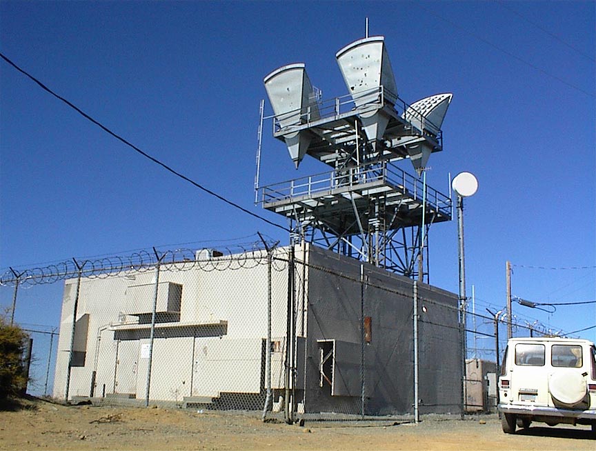
Any "pads" or fenced areas can be easily seen and counted by anyone as previously shared:

Lat/Long I gave for the repeater sites can be pasted into Google Maps, switch to satellite view and zoom in to see how they are laid out.

33°50'31.4"N 116°49'26.7"W and using the Google Maps distance function the buildings are only 600' apart.

The trick is figuring out who is in the buildings, LOL.

By studying this old AT&T map it can be seen that the site was called already Ranger quite a long time ago. AT&T towers had the classic cornucopia horns that needed those flat steel platforms with the large square holes in them. Ranger used to have paths to Keller, Joshua Tree and downtown San Bernardino. As AT&T shut down their microwave system the buildings became prime comms sites and many were purchased by American Tower (although Ranger does not seem to be one of them).

ATT_SOCAL_MAP_1987.jpg

Source: AT&T Long Lines Places and Routes

Many comms sites were started by AT&T long before there was much of a mobile radio industry. Here is an example of the old microwave horns.

DSC00016a.jpg


However, Ranger Peak was named by the USFS for a fire lookout that once existed there consisting of a 20' open timber tower with an 8' x 8' wood cab (1935) (Source Bob Burd). Here is one of his photos of the remaining concrete piers.

DSCF1865.jpg


Quite a number of other comms sites have been built at locations from the old Nike Missile system the Army operated. Mount Disappointment is one example.

Nike Site Locations & Status
Nike Missiles
 
Last edited:

Teotwaki

Member
Joined
Aug 3, 2008
Messages
578
Location
SoCal
Thank You for all of the information that you post including those maps of the repeaters and the tones and everything else. You created this thread and seems to always add good information and you study the forest system and all of those antenna's and radios that you most likely listen to up in the mountains.


Looking at the first post it looks to be member "mgannaway" who created the thread :cool: but overall credit goes to all of the USFS enthusiasts who have kept the information flowing.
 

allend

Member
Premium Subscriber
Joined
Feb 1, 2012
Messages
1,378
Location
Long Beach, CA
Yup you are right. Credit goes to everybody that contributes to the thread. Gather all the information and then piece it together
 

zz0468

QRT
Banned
Joined
Feb 6, 2007
Messages
6,034
33°50'31.4"N 116°49'26.7"W and using the Google Maps distance function the buildings are only 600' apart.

The trick is figuring out who is in the buildings, LOL.

That's the fun part!

Going partly from memory, and partly from historical records I have, the AT&T site was KNL59, and had 4, and 11 GHz paths, but it wasn't a really heavy route.

The building immediately adjacent to it, I believe was a cable TV system. It picked up a microwave signal from North Mountain, that overlooks Hemet and San Jacinto, and sent it down the Banning pass. This is the memory part, and I'm not 100% certain of it's current status. I KNOW that the North Mountain cable headed site is something else now, but the little thing by the old AT&T building looked like it was still in service.

The site to the furthest northwest is Riverside County PSEC.

The State of California has a site about midway between the fire station and the AT&T site.

By studying this old AT&T map it can be seen that the site was called already Ranger quite a long time ago. AT&T towers had the classic cornucopia horns that needed those flat steel platforms with the large square holes in them. Ranger used to have paths to Keller, Joshua Tree and downtown San Bernardino.

There are some Google Earth plug ins that have the old AT&T route maps on them, and they seem to be quite good. Most of the sites are still there, some have been completely removed. Some still have the cornies on the towers, mostly the really remote ones.

As AT&T shut down their microwave system the buildings became prime comms sites and many were purchased by American Tower (although Ranger does not seem to be one of them).

Last I was up there, the building was indeed owned by American Towers, and as they once told me when I inquired, "We don't sell buildings, we buy them". In other words, they still own it.

However, Ranger Peak was named by the USFS for a fire lookout that once existed there consisting of a 20' open timber tower with an 8' x 8' wood cab (1935) (Source Bob Burd). Here is one of his photos of the remaining concrete piers.

I don't know if you're a ham, but that foundation is an excellent place to set up a portable station and do SOTA stuff.

Quite a number of other comms sites have been built at locations from the old Nike Missile system the Army operated. Mount Disappointment is one example.

Pleasants Peak is another.
 

Kingscup

Member
Feed Provider
Joined
Jun 1, 2006
Messages
620
I have noticed many units around the state are not even giving the Tone number verbally anymore. Do they in RRU?


Generally no. The only time they may advise of a tone number is if it is not a tone not used regularly. I.E another response area or the far reaches of their own response area.
 
Top