Finding Sectors on Charts

Status
Not open for further replies.

N7OLQ

Scanning since '77
Premium Subscriber
Joined
Dec 17, 2001
Messages
322
Location
Utah
I've been scanning a long time, but aircraft monitoring has never been much of a focus. I'm trying to understand the structure. Right now, I just have a jumble of aircraft freqs loaded. A few of my scanners actually have the local RR DB freqs. and some just have all the local hits in the air band. I'm trying to understand the frequency handoffs in relation to the charts. I have SLC TAC, SLC, ENR High03, Low09, etc. I'm also aware (and fascinated by) tracking pages like FlightRadar24, etc.
My first question is where do I find the 'Sectors'? I hear a lot of traffic on freqs from rr db with the Sector 32 or 33 label. I can't find those references on the chart.
Lots more questions, but one thing at a time. I could not find a "Scannist's Guide to Sectional Charts" anywhere.
Thanks
 

ATCTech

Active Member
Joined
Aug 13, 2002
Messages
1,857
FWIW, ATC sectors and sectional charts are two different things entirely. I suspect you already knew that.

Cheers!
 

N7OLQ

Scanning since '77
Premium Subscriber
Joined
Dec 17, 2001
Messages
322
Location
Utah
FWIW, ATC sectors and sectional charts are two different things entirely. I suspect you already knew that.

Cheers!
No. I didn't, so that helps (I can stop looking). I figured pilots needed to know sectors, so it would be on their charts. Are there documents for ATC sectors?
 

dlwtrunked

Member
Premium Subscriber
Joined
Dec 19, 2002
Messages
2,383
No. I didn't, so that helps (I can stop looking). I figured pilots needed to know sectors, so it would be on their charts. Are there documents for ATC sectors?

Generally the FAA wants the pilot to go to the frequency they are told rather than trying to try to figure out ones from maps particularly since those may change, frequencies may have an equipment or interference problem, etc. Pilots generally do not have any maps showing Sectors.
In addition, there is only so much information you can put on a map and one does not want them to have too many maps. So the maps give them enough information to make contact to be directed to another frequency if needed.

If you have not been there and like maps, also get the other free digital maps for you location from:
And if you have not, get the Chart Supplements:
 

ATCTech

Active Member
Joined
Aug 13, 2002
Messages
1,857
Nope, flight crews have no need to know ATC sector boundaries. Published airway charts show primary frequencies for the area of interest to the flight crew but that's it. We had our sector boundaries overlaid onto the necessary high, low or terminal area charts for the controllers so they could visually reference his/her area of responsibility relative to airways, NAVAIDs etc., but again, just an internal thing we did.
 

AirScan

Member
Premium Subscriber
Joined
Feb 13, 2007
Messages
3,026
My first question is where do I find the 'Sectors'? I hear a lot of traffic on freqs from rr db with the Sector 32 or 33 label. I can't find those references on the chart.

In the US the sector charts are published separately by each individual Center. Boston and New York are the only Centers I'm aware of that that publish basic sector charts and distribute them as part of a NOTAM. Links - New York NOTAM and Boston NOTAM.

Sector charts are usually published as part of the Centers SOP (Standard Operating Procedures Manual). You can obtain them but it usually requires filing an FAA FOIA Request.

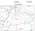
Here's an example from the Salt Lake City SOP
ZLC 32.jpg

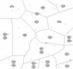
Because the FAA couldn't be bothered to provide them (easily), I've put together my own sector charts. Here's what I have for High Altitude around the SLC area.


ZLC High.jpg

PM me if you want more info.
 
Last edited:

N7OLQ

Scanning since '77
Premium Subscriber
Joined
Dec 17, 2001
Messages
322
Location
Utah
That is very helpful. I'll have to figure out the geographical references, but VOR towers look like markers.
 

N7OLQ

Scanning since '77
Premium Subscriber
Joined
Dec 17, 2001
Messages
322
Location
Utah
Sector charts are usually published as part of the Centers SOP (Standard Operating Procedures Manual). You can obtain them but it usually requires filing an FAA FOIA Request.

PM me if you want more info.

How did you go about creating your own charts? Listening? FOIA?
 

AirScan

Member
Premium Subscriber
Joined
Feb 13, 2007
Messages
3,026
How did you go about creating your own charts? Listening? FOIA?

Both. Mostly LiveATC, Global Tuners (not as good as it used to be), and personal monitoring (travel a lot). I've posted my High Altitude Eastern charts over at LiveATC. Link - LiveATC JetScan1 Charts. Any updates or feedback from anyone always appreciated.
 
Last edited:

alexgeo

Member
Joined
Nov 3, 2015
Messages
18
Location
Northern CA
Sector maps are hard to come by. Try googling your local TRACON / ARTCC name + "pdf" and see if any official FAA documentation comes up. Sometimes you can find facility order manuals which may be helpful.

If you're looking for a very rough outline of frequency boundaries you can find some approach/departure (TRACON) frequencies on the VFR sectional. Go to Skyvector, click on "World VFR" and look for the magenta boxes. The boxes rougly correlate to where the frequencies are used. You can also find center frequencies by looking at low/high enroute charts (click "World Lo" for 18,000ft and below or "World Hi" for FL180 and above). Look for the blue postage stamp boxes to find the center (ARTCC) frequencies. It's not perfect because many of the frequencies seem to be omitted, but it's a good starting point.

SkyVector: Flight Planning / Aeronautical Charts

norcaltracon.PNGZOA.PNG
 

alexgeo

Member
Joined
Nov 3, 2015
Messages
18
Location
Northern CA
Forgot to add--if you're located in an area with class B airspace, you'll have to look at the corresponding VFR TAC chart for the area and find the blue boxes for the corresponding TRACON frequencies. Magenta is for class C only. It's been a while ;)
TAC.PNG
 

AirScan

Member
Premium Subscriber
Joined
Feb 13, 2007
Messages
3,026
That is very helpful. I'll have to figure out the geographical references, but VOR towers look like markers.

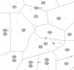
You can use the VORs as reference. I tweaked the chart a bit to update a few things.

ZLA SLC Area.jpg

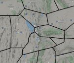
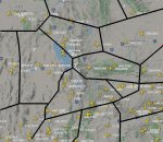
Here's what the sector boundaries look like on the FlightRadar24 Map.

ZLC FR24.jpg


ZLC FR24 traffic.jpg

From your location are you able to hear the Center controllers on any of these frequencies ?
 
Last edited:

N7OLQ

Scanning since '77
Premium Subscriber
Joined
Dec 17, 2001
Messages
322
Location
Utah
That's super helpful. Yes, I'm a little south of SLC and I can hear both sides for the sectors to the south of SLC. I have not tried the other sectors yet. There seem to be about 4 main flight corridors for commercial traffic. Just to confirm, what altitude do these sectors cover? I assume it is the lower stuff and not the fly-over.
 

AirScan

Member
Premium Subscriber
Joined
Feb 13, 2007
Messages
3,026
Just to confirm, what altitude do these sectors cover? I assume it is the lower stuff and not the fly-over.

The altitudes covered are shown on the chart for each sector, listed under the frequency box.

For example -
000A = Surface and Above (not including Approach if applicable). (Controlled airspace goes up to FL600 in the USA).
000-320 = Surface to FL320.
330A = FL330 and Above. (up to FL600).
350B = FL350 and Below.
Etc.

* - indicates the frequency is used when required/secondary
+ (boxed) - indicates sectors merge as required

For example ZLC03 119.550 covers airspace from the Surface up to FL600, and merges with ZLA04 135.775 as required. ZLA04 extends from FL330 to FL600 (sits overtop ZLC32), except for an eastern shelf that extends from the Surface to FL600.

127.925 covers FL360 and Above and merges with ZLC 120.275 FL360 and Above as required, when they are combined 127.925 is used in both sectors.

How far south of SLC are you ? What frequencies are you hearing the controller on ?

here seem to be about 4 main flight corridors for commercial traffic.

It's also helpful to know the Arrival (STAR) and Departure (DP) routes. These can be found on the FAA Terminal Procedures website. For example the QWENN 5 Arrival into KSLC.
 
Last edited:

n2nov

Active Member
Joined
Dec 18, 2002
Messages
832
Location
Staten Island, NYC
You can use the VORs as reference. I tweaked the chart a bit to update a few things.
...
Here's what the sector boundaries look like on the FlightRadar24 Map.
...
From your location are you able to hear the Center controllers on any of these frequencies ?
Nice! Could you share how you did this so that I can make up similar maps for the NYC tri-state area? Thanks.
 

AirScan

Member
Premium Subscriber
Joined
Feb 13, 2007
Messages
3,026
Not quite. Above FL600 is Class E airspace, which is very much controlled. The only uncontrolled airspace in the US is Class G.

My mistake. While the FAA maintains the Authority above FL600, do the ARTCC facilities have the mandate/capability to actively control aircraft that high ? I always just figured they would be cleared to FL600 then above that it would be, "radar services terminated, cleared enroute" sort of thing ?
 
Last edited:

AirScan

Member
Premium Subscriber
Joined
Feb 13, 2007
Messages
3,026
Nice! Could you share how you did this so that I can make up similar maps for the NYC tri-state area? Thanks.

I'm not sure what you mean ? The chart itself or the sector overlay on the FR24 map ? For the FR24 map it was nothing fancy just cut and past the sector layout over the screen shot of the other map. For the chart, you can download my notes here - Northeast High Altitude Notes.
 
Last edited:

alcahuete

Member
Premium Subscriber
Joined
Jul 24, 2015
Messages
2,659
Location
Southern California
My mistake. While the FAA maintains the Authority above FL600, do the ARTCC facilities have the mandate/capability to actively control aircraft that high ? I always just figured they would be cleared to FL600 then above that it would be, "radar services terminated, cleared enroute" sort of thing ?

Oh no, they're absolutely controlled up there. It's treated the same as all other Class E airspace.
 
Status
Not open for further replies.
Top