I have heard periodic Inyo SO Transmissions on the new system, as more and more activity happens the more ill know as per RAN and talk ids, BTW the only way i knew of the SO transmissions was they had made it known on the old system to switch over, and yes it was indeed encrypted , kind of sounded like maybe the regular Kenwood 15 bit, which is kind of like speech inversion on DMR more updates to come as i get them

You are using an out of date browser. It may not display this or other websites correctly.
You should upgrade or use an alternative browser.
You should upgrade or use an alternative browser.
Inyo County Moving to Mobile Relay Associates NEXEDGE System?
- Thread starter mcjones2013
- Start date
- Status
- Not open for further replies.
I live in Mono County and my knowledge of the systems in it exceed what I know of Inyo Counties. I can hear nearly every repeater on various county and local systems from my home, with the exception of Leviathan Peak near the northern Mono County boundary and low level repeaters located near Walker, California. The only Inyo County repeater site I can hear is Silver Peak near Bishop. I do travel to Bishop frequently, through parts of Inyo County nearly annually and other portions such as Shoshone only every few years.
Last edited:
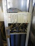
this is a picture of the DWP site at Glass Mtn View attachment 112823
When I was on top of Glass Mountain a couple of times back in the 1990's the USFS site was on the north side of large flat area of the mountain. DWP was southeast of the USFS site and all by itself. I think DWP only had UHF at the site, with no VHF-Low installed there. I could see their site on Google Earth as the top of the mountain is quite bare of any features. Currently DWP gave up nearly all of its licenses for UHF everywhere they operate. They have no licenses for Glass Mountain on their new 900 MHz system. With no licenses it is no surprise that looking at the top of the mountain the site southeast of the USFS site is gone. They cleaned it up well enough that I can't see anything left when using Google Earth.
The picture you posted above matches the view from Google Earth that I think is the USFS site. The southernmost part of the structure is a solar panel, then the vault and finally the northernmost portion being the antenna structure with 4 antennas mounted. Three appear to be VHF. Two of those would be the north Forest Net and the Service Net. I'm not sure what the third VHF antenna would be. The very short vertical with the short beam aimed toward what I would assume Silver Peak is a mystery. The vault or building is new since the last time I was up there, but nearly in the same location. When I was there federal property signs were posted on the door. I don't see any signs on the building in your picture.
If DWP has no licenses for the top of the peak it would not make sense for them to have a building like this. If this isn't the USFS installation then I can't find it anywhere else in the Google Earth view of the mountaintop. I'm not saying you are wrong, I just can't get my knowledge of the peak, your picture and the lack of DWP licenses to match. Any additional info would be appreciated.
Another question is what is the date of this photo?
i was told microwave is still active at that site via DWP, dwp cut there UHF long just before 2000, the USFS moved into the DWP building years ago long before i came on and should currently have in there what i installed for north and south a dual VHF Daniel's Repeater in a nice one space 19" rack mount as well as two compact EMR vhf duplexers located under the repeater in the rack incidentally DWP was installing Brand new battery's, 2007 the very same day i installed my new equipment or the USFS equipment
Just looked at google earth and see the Pole with the VHF Stationmasters are still there, there are two of them mounted on that pole, one is no good and the other that's the north vhf, I can still see 5 antennas affixed to the building scaffolding the antenna on the north face of the scaffolding the side opposite of the door and mounted on the highest pole is the south vhf and in front of the solar array is the microwave antenna between what appears to be four poles or wooden mounting of some sort
I stated wrong,, hope this don't mean I'm getting too old, as per my post ( back then Glass didn't have a service net up there just the two vhf for north and south, might be the current tech placed it in recent years
after looking at my records yes there had been a service net repeater on glass, with the old system, and some sort of APRS Digi System. but I'm telling you I don't remember installing an upgraded NB system for it at glass, could be i didn't have it to install at the time and the priority was focused on both the north and south links,, also could have been it didn't get installed till after I left as I only installed what I had available to me at the time as it was a mess as none of frequency's i was given to use were actually coordinated at the time, i went with what regional told me to do. I believe the north link frequency changed a couple times after the install due to FCC licensing as per the APRS Digi I removed it per Regional request
after looking at my records yes there had been a service net repeater on glass, with the old system, and some sort of APRS Digi System. but I'm telling you I don't remember installing an upgraded NB system for it at glass, could be i didn't have it to install at the time and the priority was focused on both the north and south links,, also could have been it didn't get installed till after I left as I only installed what I had available to me at the time as it was a mess as none of frequency's i was given to use were actually coordinated at the time, i went with what regional told me to do. I believe the north link frequency changed a couple times after the install due to FCC licensing as per the APRS Digi I removed it per Regional request
yes the building is owned by DWP who allows the USFS a rack space in it, it has not been abandoned by DWP there is a current upgrading expansion going on by DWP, it just hasn't hit are area yet but I'm been assured planning is in progress and so will the FCC license's to follow, also was told they were just up there two months ago, installing upgraded equipment, now whether it's some sort of microwave or upgraded DMR system i don't know i didn't ask, didn't come up, we got into a discussion on how the upgrade expansion of new sites were only being given GPS coordinates right now no other informationWhen I was on top of Glass Mountain a couple of times back in the 1990's the USFS site was on the north side of large flat area of the mountain. DWP was southeast of the USFS site and all by itself. I think DWP only had UHF at the site, with no VHF-Low installed there. I could see their site on Google Earth as the top of the mountain is quite bare of any features. Currently DWP gave up nearly all of its licenses for UHF everywhere they operate. They have no licenses for Glass Mountain on their new 900 MHz system. With no licenses it is no surprise that looking at the top of the mountain the site southeast of the USFS site is gone. They cleaned it up well enough that I can't see anything left when using Google Earth.
The picture you posted above matches the view from Google Earth that I think is the USFS site. The southernmost part of the structure is a solar panel, then the vault and finally the northernmost portion being the antenna structure with 4 antennas mounted. Three appear to be VHF. Two of those would be the north Forest Net and the Service Net. I'm not sure what the third VHF antenna would be. The very short vertical with the short beam aimed toward what I would assume Silver Peak is a mystery. The vault or building is new since the last time I was up there, but nearly in the same location. When I was there federal property signs were posted on the door. I don't see any signs on the building in your picture.
If DWP has no licenses for the top of the peak it would not make sense for them to have a building like this. If this isn't the USFS installation then I can't find it anywhere else in the Google Earth view of the mountaintop. I'm not saying you are wrong, I just can't get my knowledge of the peak, your picture and the lack of DWP licenses to match. Any additional info would be appreciated.
Another question is what is the date of this photo?
so I think in other words it too soon to know anything as its still in the making and planning, i will just say this, the last time i was up there, June 2007, there were no UHF or VHF low, high or 900mhz systems being use by DWP. just some really impressive telemetering equipment for the dam, which ive been told hasn't changed, and after looking at the FCC page its really hard for me to see June Mountain (the only site listed in the data base for Mono" handling all of the Mono County End of their extensive system, why anything up around Crowley lake or Conway Summit are not in the FCC data base i don't know either?? very puzzling
Finally found this, on Glass Mtn. I always take pictures of the sites i work at :thought i was loosing it: this picture was taken just before I removed the equipment from the rack, looking at the picture, corresponds with my memory, "Thank GOD" i only see one VHF and that was the old forest net, the other radio is an Midland hooked up for APRS, both were removed. so there wasn't a service net up there when I upgraded the site to NB, Must have been added after i left, there were two antennas both i had to replace i cant find the pole pictures however i took a picture of the mount i didn't like for the south link antenna, when i returned to turn on the system a week later. I replaced it with a longer pole to get the antenna away from the others at least a wave length.
Attachments
the first two antennas from the east side, the door side, located on the scaffolding are two UHF 450mhz , the middle short one with the little beam was a cellular link for the telemetry and yes pointed at Silver. none no longer in use. and the very last one opposite end of the door was what i installed for the Forest net south "only VHF on the building scaffolding" on the pole which you cannot see in the photo i provided but as of 9-14-2019 from google earth is still there are two BIG VHF Stationmaster's, the one that's mounted away from the pole about a foot is the one i installed the existing Stationmaster was mounted directly against the pole probably why it didn't pass my Site master test, the GOOD antenna as i call it now is the Forest net North antennaWhen I was on top of Glass Mountain a couple of times back in the 1990's the USFS site was on the north side of large flat area of the mountain. DWP was southeast of the USFS site and all by itself. I think DWP only had UHF at the site, with no VHF-Low installed there. I could see their site on Google Earth as the top of the mountain is quite bare of any features. Currently DWP gave up nearly all of its licenses for UHF everywhere they operate. They have no licenses for Glass Mountain on their new 900 MHz system. With no licenses it is no surprise that looking at the top of the mountain the site southeast of the USFS site is gone. They cleaned it up well enough that I can't see anything left when using Google Earth.
The picture you posted above matches the view from Google Earth that I think is the USFS site. The southernmost part of the structure is a solar panel, then the vault and finally the northernmost portion being the antenna structure with 4 antennas mounted. Three appear to be VHF. Two of those would be the north Forest Net and the Service Net. I'm not sure what the third VHF antenna would be. The very short vertical with the short beam aimed toward what I would assume Silver Peak is a mystery. The vault or building is new since the last time I was up there, but nearly in the same location. When I was there federal property signs were posted on the door. I don't see any signs on the building in your picture.
If DWP has no licenses for the top of the peak it would not make sense for them to have a building like this. If this isn't the USFS installation then I can't find it anywhere else in the Google Earth view of the mountaintop. I'm not saying you are wrong, I just can't get my knowledge of the peak, your picture and the lack of DWP licenses to match. Any additional info would be appreciated.
Another question is what is the date of this photo?
each mountain site has both Forest north and south repeaters in them originally meant to be Forest net 1 Forest net 2 which both nets would cover the whole 395 corridor, however over the last few years and different techs working. it had changed to the north and south, not what it was intended to be at all, as the way i set it up was no matter what district 1 2 3 and 4 you would be able to talk all around meaning someone at say Lee Vining ranger station would be able to bring up any of the south tones on either net so Lee Vining could talk to Lone pine and vice versa so don't know what happened there.. kind of depressing the way its set up now
Last edited:
ok ok ok i figured it out even though the USFS service net uses tone 3, which got me when i looked at it as tone 3 refers to the Glass Mtn Tone. the service net repeater is actually located at the Bald Mtn Lookout, i found my old plans and there was a NB upgrade at Bald Mtn Service Net tone 3 Just looked at Google Earth at the Bald Mtn Lookout and the Black Telwave VHF Dipole antenna is still mounted there, thats the Service Net repeater antenna
I came across information this summer, I think on the Dexter Fire 205's that showed the location of the Service Net no longer on Bald Mountain, but on Glass Mtn. I think this move was made in the last 3-4 years. The R5 Frequency Guide shows Tone 3 of the Inyo's Service Net to be on Glass Mountain. I think it has been shown that way for about 2-3 years. I don't have time right now to look back in previous years version of the guide to be able to nail that down. So much to do right now to get ready for the next series of storms (2 at this point), this clear, warm weather can't last forever, although the weather seems to be doing unprecedented things as most of us have observed.
Yes i think your right as Glass is in my back yard and i can hit the service net full bars, if I had originally designed the system and not just made work what was on paper work.. I would have placed it on Glass to begin with==makes more since,, and I'm thinking it was placed as recently as after the google map photo 12-14-19 unless the current tech pulled the south net out of there,, which wouldn't make a difference as how the system is run now, when i make an appearance with the current tech ill find out all there is to know. still doing a lot of catch up and i have more pressing issue to contend with right now.. so the saga continues. BTW while i was on the Forest there was suppose to be a travel net on several of the peaks Silver, Maz, Conway, Cerro Gordo however there was no such repeaters on any of those peaks, and the last i saw of the travel net was in 2005 USFS frequency guide, i can assure you that it didn't exist in any of those site between 1999 -2007
I think Mike put travel net on Bald so that he had a repeater he could drive to. Glass requires a helicopter so if the north net goes down due to power issues anything else up there goes out as well. The Service Net is used as kind of a backup system and sometimes command so being able to drive to it in case of problems was an advantage. The disadvantage being it doesn't have near the coverage Glass has.
Yes, the travel net saga. I think the directories showed it on Conway and Silver or Mazourka or Cerro Gordo. That is some long distance coverage, but that is how the net was designed. Then for some reason, travel net was taken away by another agency, which included the equipment as well. So some other agency just took the whole thing away from us. It's OK as widespread cell phone coverage made the net a bit unnecessary. However, we needed a travel frequency so the state volunteered their OES VHF net or CSERS as I think it is called. I think the direction to use it only on simplex is OK as it just needed so that vehicles traveling together, like a bus for a Type 2 crew and the crew bosses pickup can talk about where to turn at intersections, what restaurant everyone wants to go to, what lane to change to so as to make the correct paths at freeway interchanges and similar. If units need a repeater that suggests they aren't traveling close enough. A travel frequency is also needed for engine strike teams. The state might need a travel frequency more than the feds as they are always moving crews and engines around all over California, possibly more than the feds do.
I kerchunked the Travel Net when I was traveling and I seem to remember doing so in Bridgeport to test Conway and got the kickback squelch tail. I think I did the same for Mazourka or Cerro Gordo with the same result, but from Olancha or Little Lake. Speaking of Olancha, I could communicate fully on it from the top of Cajon Pass and then lost it just north of Kramer Junction until south of Ridgecrest, near that southern Trona intersection.
What sucks about the Travel Net is that an unknown agency took the travel net from us isn't using it anymore. The 169.1250 output frequency is now an air to ground on the national list. It is used in California and I think the old input frequency is used by the wildland fire agencies for something or other now. One problem the travel net had was the radio techs never really made the system well known to the ground troops who could have used it. We just did the old "Let's monitor Tac 2" to communicate with each other. Tac 2 used to sound like an extremely busy CB Channel 19 when you would drive up and down the Calif. Central Valley. When I would suggest we all use "Travel Net," no one seemed to know what it was even though it was shown on the back page of the Regional Frequency Guide. But now the ground troops have the option of CSERS on 153.7550, cell phones or texting each other to conduct logistical comms.
I went to fires all over California and did personnel misconduct investigations, somewhat like fires, on an on call basis. I've used at least half the forest nets in R5 as I was on a fire or an investigation on 11 forests total. One last tidbit, I was on U.S. 101 between Santa Marquita and Paso Robles in brought up Mammoth Mountain (Tone 2) on the Inyo's Forest Net while on a fire on the Los Padres. It was scratchy, but I did talk with the ranger station in Mammoth.
oh yes there is quite the back coverage of Mammoth And Mt Warren one never thinks about, i have hit both in many areas in Fresno and on up 5 going north, Warren on a good clear day, see's the Ocean as one of the problems i ran into with both Mammoth and Warren was ocean rhyme mixed with ice really played havoc on the antennas, Years ago when i first was introduced to Mike, I was involved with JPL and he had helped me when I was performing experiment's for NASA on White Mtn I ran into that same rhyme, nasty stuffI think Mike put travel net on Bald so that he had a repeater he could drive to. Glass requires a helicopter so if the north net goes down due to power issues anything else up there goes out as well. The Service Net is used as kind of a backup system and sometimes command so being able to drive to it in case of problems was an advantage. The disadvantage being it doesn't have near the coverage Glass has.
Yes, the travel net saga. I think the directories showed it on Conway and Silver or Mazourka or Cerro Gordo. That is some long distance coverage, but that is how the net was designed. Then for some reason, travel net was taken away by another agency, which included the equipment as well. So some other agency just took the whole thing away from us. It's OK as widespread cell phone coverage made the net a bit unnecessary. However, we needed a travel frequency so the state volunteered their OES VHF net or CSERS as I think it is called. I think the direction to use it only on simplex is OK as it just needed so that vehicles traveling together, like a bus for a Type 2 crew and the crew bosses pickup can talk about where to turn at intersections, what restaurant everyone wants to go to, what lane to change to so as to make the correct paths at freeway interchanges and similar. If units need a repeater that suggests they aren't traveling close enough. A travel frequency is also needed for engine strike teams. The state might need a travel frequency more than the feds as they are always moving crews and engines around all over California, possibly more than the feds do.
I kerchunked the Travel Net when I was traveling and I seem to remember doing so in Bridgeport to test Conway and got the kickback squelch tail. I think I did the same for Mazourka or Cerro Gordo with the same result, but from Olancha or Little Lake. Speaking of Olancha, I could communicate fully on it from the top of Cajon Pass and then lost it just north of Kramer Junction until south of Ridgecrest, near that southern Trona intersection.
What sucks about the Travel Net is that an unknown agency took the travel net from us isn't using it anymore. The 169.1250 output frequency is now an air to ground on the national list. It is used in California and I think the old input frequency is used by the wildland fire agencies for something or other now. One problem the travel net had was the radio techs never really made the system well known to the ground troops who could have used it. We just did the old "Let's monitor Tac 2" to communicate with each other. Tac 2 used to sound like an extremely busy CB Channel 19 when you would drive up and down the Calif. Central Valley. When I would suggest we all use "Travel Net," no one seemed to know what it was even though it was shown on the back page of the Regional Frequency Guide. But now the ground troops have the option of CSERS on 153.7550, cell phones or texting each other to conduct logistical comms.
I went to fires all over California and did personnel misconduct investigations, somewhat like fires, on an on call basis. I've used at least half the forest nets in R5 as I was on a fire or an investigation on 11 forests total. One last tidbit, I was on U.S. 101 between Santa Marquita and Paso Robles in brought up Mammoth Mountain (Tone 2) on the Inyo's Forest Net while on a fire on the Los Padres. It was scratchy, but I did talk with the ranger station in Mammoth.
mmckenna
I ♥ Ø
One last tidbit, I was on U.S. 101 between Santa Marquita and Paso Robles in brought up Mammoth Mountain (Tone 2) on the Inyo's Forest Net while on a fire on the Los Padres. It was scratchy, but I did talk with the ranger station in Mammoth.
USGS used to have a telemetry link from Mammoth Mountain straight back to Mt. Hamilton above San Jose. No longer there, but at the time it was a 5 watt VHF hand held strapped to the wall and wired to a power supply. Yagi antenna on the San Jose end. No idea what was on the MM end.
Paso Robles to Mammoth is pretty impressive though. That's not a clear shot through the hills.
Thanks for sharing your info. I've done a lot of camping and ATV riding out in the Crestview area, ridden into Mammoth Mountain, all the way up to Bodie and north. Some beautiful country.
that would be the old APRS system similar to what the hams use, it was on 170.525 The Forest Service was using it for GPS tracking of vehicles and also installed in some air craft also used on the packet side was monitoring of the snow packs. towards the end of this system, I had built several weather monitoring stations to be used on controlled burns, which at the time could be monitored be Dispatch and reginal offices, this was before the satellite system came out they may still be currently using now "forget the name of it"USGS used to have a telemetry link from Mammoth Mountain straight back to Mt. Hamilton above San Jose. No longer there, but at the time it was a 5 watt VHF hand held strapped to the wall and wired to a power supply. Yagi antenna on the San Jose end. No idea what was on the MM end.
Paso Robles to Mammoth is pretty impressive though. That's not a clear shot through the hills.
Thanks for sharing your info. I've done a lot of camping and ATV riding out in the Crestview area, ridden into Mammoth Mountain, all the way up to Bodie and north. Some beautiful country.
- Status
- Not open for further replies.
Similar threads
- Replies
- 9
- Views
- 522
- Replies
- 46
- Views
- 4K
- Replies
- 41
- Views
- 4K
- Replies
- 9
- Views
- 867