New air monitoring questions

galligan122

Member
Premium Subscriber
Joined
Mar 16, 2024
Messages
112
Reaction score
23
Location
Wabash IN
Hey guys,

I am very new to monitoring air traffic. I’ve only ever dove into police/fire/ems and have a good grasp on the public safety scanning.

I particularly want to hear the Wabash Municpial Airport in Wabash Indiana, and air traffic that is flying in the airspace near me.

The Wabash airport uses a frequency of 122.8 csq and when the planes are actually at the Wabash Airport or close I hear them really well. The problem is, this channel picks up a LOT of other traffic that is usually unreadable and leads to a lot of annoying traffic. I have adjusted squelch which helped a little but was wondering if there were any other solutions.

Also, I heads a plane on a different frequency that mentioned they were flying over Wabash. It was a frequency assigned high altitude if I understood correctly.

so my questions are, what frequencies do I need to have to ensure I hear traffic in my area, and not distant areas, and is there a way to limit so I’m not getting static from 150-200 miles away being a csq tone?

Thanks!
 

imonitorit

Member
Joined
Jan 16, 2003
Messages
185
Reaction score
78
Location
New London County, Connecticut
Hope this helps. Go to Aviation Charts on Google Maps | iFlightPlanner in the search box type in KIWH then click GO. Zoom in and out, you will see other airfields share that same frequency too. Click on the green dot at the other larger airports to get the tabs where you can see the frequencies used. Check the IFR low and IFR sectional maps for ARTCC info.
 

nd5y

Member
Joined
Dec 19, 2002
Messages
12,256
Reaction score
4,467
Location
Wichita Falls, TX
122.8 is a common CTAF and or Unicom frequency used at many airports. Sometimes airports that are near eachother. There is no way to limit what you hear to only certain things if they are all on the same frequency and there is no tone squelch as is the case with the AM aircraft bands. The only thing you can do is use attenuation or a lower or worse antenna to limit what you can receive to strong local signals but then you might not hear what you want to hear.

Check AirNav: KIWH - Wabash Municipal Airport and see if you have the right frequencies and also Wabash County, Indiana (IN) Scanner Frequencies and Radio Frequency Reference and RadioReference Database.

SkyVector: Flight Planning / Aeronautical Charts and VFRMAP - Digital Aeronautical Charts have charts with frequencies if you know how to read the charts.
 

galligan122

Member
Premium Subscriber
Joined
Mar 16, 2024
Messages
112
Reaction score
23
Location
Wabash IN
122.8 is a common CTAF and or Unicom frequency used at many airports. Sometimes airports that are near eachother. There is no way to limit what you hear to only certain things if they are all on the same frequency and there is no tone squelch as is the case with the AM aircraft bands. The only thing you can do is use attenuation or a lower or worse antenna to limit what you can receive to strong local signals but then you might not hear what you want to hear.

Check AirNav: KIWH - Wabash Municipal Airport and see if you have the right frequencies and also Wabash County, Indiana (IN) Scanner Frequencies and Radio Frequency Reference and RadioReference Database.

SkyVector: Flight Planning / Aeronautical Charts and VFRMAP - Digital Aeronautical Charts have charts with frequencies if you know how to read the charts.
Thank you! So if I understand right, the approach and departure traffic is actually handled by Grissom, so I’d need to add those frequencies. These other frequencies though I don’t quite understand, can you shed some light into when they are used?

Thanks!

CTAF/UNICOM:​
122.8
GRISSOM APPROACH:​
121.05
GRISSOM DEPARTURE:​
121.05
WX AWOS-3PT at HHG (16 nm E):​
126.575 (260-454-1927)
WX AWOS-3 at MZZ (17 nm S):​
108.6 (765-674-1317)
WX AWOS-3PT at OKK (18 nm SW):​
128.675 (765-452-3014)


galligan122

Member
Premium Subscriber
Joined
Mar 16, 2024
Messages
112
Reaction score
23
Location
Wabash IN
122.8 is a common CTAF and or Unicom frequency used at many airports. Sometimes airports that are near eachother. There is no way to limit what you hear to only certain things if they are all on the same frequency and there is no tone squelch as is the case with the AM aircraft bands. The only thing you can do is use attenuation or a lower or worse antenna to limit what you can receive to strong local signals but then you might not hear what you want to hear.

Check AirNav: KIWH - Wabash Municipal Airport and see if you have the right frequencies and also Wabash County, Indiana (IN) Scanner Frequencies and Radio Frequency Reference and RadioReference Database.

SkyVector: Flight Planning / Aeronautical Charts and VFRMAP - Digital Aeronautical Charts have charts with frequencies if you know how to read the charts.
I was afraid that would be the case, and thank you for the info and the links! I will read over them
 

alcahuete

Member
Premium Subscriber
Joined
Jul 24, 2015
Messages
2,824
Reaction score
2,691
Location
Southern California
Thank you! So if I understand right, the approach and departure traffic is actually handled by Grissom, so I’d need to add those frequencies. These other frequencies though I don’t quite understand, can you shed some light into when they are used?

Thanks!

CTAF/UNICOM:​
122.8
GRISSOM APPROACH:​
121.05
GRISSOM DEPARTURE:​
121.05
WX AWOS-3PT at HHG (16 nm E):​
126.575 (260-454-1927)
WX AWOS-3 at MZZ (17 nm S):​
108.6 (765-674-1317)
WX AWOS-3PT at OKK (18 nm SW):​
128.675 (765-452-3014)

That airport is "uncontrolled" meaning there is no tower at the airport. So 122.8 (CTAF/UNICOM) is used by the pilots to announce their intentions. No ATC involved. The approach and departure frequency (the same, in this case) would handle IFR departures/approaches into the airport, as well as aircraft receiving VFR flight following. The other 3 listed (WX AWOS) is an automated weather observation system, and will basically just loop through the weather at those locations.
 

nd5y

Member
Joined
Dec 19, 2002
Messages
12,256
Reaction score
4,467
Location
Wichita Falls, TX
These other frequencies though I don’t quite understand, can you shed some light into when they are used?
Approach and Departure control the lower altitude traffic around the airport. That could include nearby non-controlled airpots.

AWOS, ASOS, and ATIS are low power continuous weather and airport information broadcasts.
 

galligan122

Member
Premium Subscriber
Joined
Mar 16, 2024
Messages
112
Reaction score
23
Location
Wabash IN
Hope this helps. Go to Aviation Charts on Google Maps | iFlightPlanner in the search box type in KIWH then click GO. Zoom in and out, you will see other airfields share that same frequency too. Click on the green dot at the other larger airports to get the tabs where you can see the frequencies used. Check the IFR low and IFR sectional maps for ARTCC i

That airport is "uncontrolled" meaning there is no tower at the airport. So 122.8 (CTAF/UNICOM) is used by the pilots to announce their intentions. No ATC involved. The approach and departure frequency (the same, in this case) would handle IFR departures/approaches into the airport, as well as aircraft receiving VFR flight following. The other 3 listed (WX AWOS) is an automated weather observation system, and will basically just loop through the weather at those locations.
Thank you so much for this info. Would there be another frequency that exists for high altitude planes flying over? I believe that’s what I heard last night but now can’t find the RR link where I found that info
 

MiCon

Mike
Joined
Feb 9, 2006
Messages
218
Reaction score
260
Location
central AZ
Let's start with the basics. For you, 122.8 is the primary frequency for your airport. Because there is no tower or ground controller, pilots are using this frequency to announce their locations and intentions, from taxiing on the airport, to taking off and landing, practice approaches, and advising other pilots in the area where they are ("departing runway 18", "turning base leg", etc).

Once in the air, they will remain on this frequency as long as they remain in the distance and altitude limits of the airport. If they leave the KIWH airspace, they will probably go to the local approach / departure frequency to talk to the local A/D controller (in your case, Grissom A/D). Again, as long as they remain within the controller's sector and altitude limits, they will stay on that frequency. If they leave that controller's sector, they will go to the next controller's freq, etc, etc.

Some sectors are quite large, some are smaller. As the altitude increases, the pilot is switched from the A/D controller (TRACON - Terminal Radar Approach CONtrol) to a 'Center' controller (ARTCC - Air Route traffic Control Center). Indianapolis or Chicago Center, in your case. These are the controllers who guide the aircraft at higher altitudes as they travel greater distances.

My suggestion to you is to monitor Grissom A/D 121.05 for a day or two and start making a list of frequencies that they switch aircraft to. Eventually you will have a list of frequencies that cover your area at all altitudes. Then, while listening to these frequencies, go to ADS-B Exchange - track aircraft live (or flight Radar 24, or Flight Aware, or any other flight tracking web site. When you hear an aircraft on a certain frequency, find that aircraft on the flight tracking web site. That will show you where the aircraft is. Click on the aircraft with your cursor, and the altitude information will come up. Eventually you'll become familiar with which frequencies you want to monitor for aircraft in your area.

Good luck, and have fun.
 

galligan122

Member
Premium Subscriber
Joined
Mar 16, 2024
Messages
112
Reaction score
23
Location
Wabash IN
Let's start with the basics. For you, 122.8 is the primary frequency for your airport. Because there is no tower or ground controller, pilots are using this frequency to announce their locations and intentions, from taxiing on the airport, to taking off and landing, practice approaches, and advising other pilots in the area where they are ("departing runway 18", "turning base leg", etc).

Once in the air, they will remain on this frequency as long as they remain in the distance and altitude limits of the airport. If they leave the KIWH airspace, they will probably go to the local approach / departure frequency to talk to the local A/D controller (in your case, Grissom A/D). Again, as long as they remain within the controller's sector and altitude limits, they will stay on that frequency. If they leave that controller's sector, they will go to the next controller's freq, etc, etc.

Some sectors are quite large, some are smaller. As the altitude increases, the pilot is switched from the A/D controller (TRACON - Terminal Radar Approach CONtrol) to a 'Center' controller (ARTCC - Air Route traffic Control Center). Indianapolis or Chicago Center, in your case. These are the controllers who guide the aircraft at higher altitudes as they travel greater distances.

My suggestion to you is to monitor Grissom A/D 121.05 for a day or two and start making a list of frequencies that they switch aircraft to. Eventually you will have a list of frequencies that cover your area at all altitudes. Then, while listening to these frequencies, go to ADS-B Exchange - track aircraft live (or flight Radar 24, or Flight Aware, or any other flight tracking web site. When you hear an aircraft on a certain frequency, find that aircraft on the flight tracking web site. That will show you where the aircraft is. Click on the aircraft with your cursor, and the altitude information will come up. Eventually you'll become familiar with which frequencies you want to monitor for aircraft in your area.

Good luck, and have fun.

Thank you for this information! The basics are absolutely what I need right now! I haven’t heard it happen yet, but I understand your post as the pilot gets told which frequent to switch to. Is it the ARTCC who assigns this frequency?
 
Last edited:

rk911

Rich
Premium Subscriber
Joined
Dec 11, 2004
Messages
652
Reaction score
266
Location
Wheaton, IL
Another excellent source for airport comms is AirNav. The Wabash airfield has no control tower so aircraft arriving and departing on a VFR (visual flight rules) flight will likely call out on the CTAF (Common Traffic Advisory Frequency).
 

alphazulu

Member
Premium Subscriber
Joined
Jul 31, 2008
Messages
72
Reaction score
37
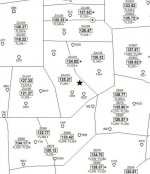
Attached is a small section of Airscan(s) High Sector Map of your area. The black star near the center is the approximate location of KIWH Wabash Municiple Airport. The small pentagon sharped objects are the VOR's (navigation aids) in that area and circling clockwise are; GSH (Goshen) - FWA (Fort Wayne) - MZZ (Marion) - OKK (Kokomo) - OXI (Knox). The Zxx are the ARTCC Centers; ZOB Cleveland Center, ZID Indianapolis Center and ZAU Chicago Center. The following 2 digit number is that center's High Sector number and underneath is the associated High Sector frequency, an ex. in your area (KIWH), ZAU34 is Chicago Center Sector 34 with a frequency of 125.375. If the map frequency ends in a 2 or 7 (100th place) add a .005 to the frequency (.025 increments), 125.37 is actually 125.375. All credit goes to Airscan for creating these outstanding detailed and accurate FAA ARTCC High Sector maps!
kiwh in.jpg
 

alphazulu

Member
Premium Subscriber
Joined
Jul 31, 2008
Messages
72
Reaction score
37
Here is a link to Skyvector.com which will which has the FAA ARTCC High & Low Charts and Sectionals of United States. In your case type in KIWH in the top left light blue box and tap "Go". Then view the different charts at top right "World Hi" "Enroute" "VFR", etc... The low sector charts will give you some low sector frequencies to add to your scanner to monitor

And next the Radio Reference Database for all nearby ARTCC Centers; ZOB Cleveland Center, ZID Indianapolis Center and ZAU Chicago Center High and Low Sector frequencies...... (TMI)
 

MiCon

Mike
Joined
Feb 9, 2006
Messages
218
Reaction score
260
Location
central AZ
Thank you for this information! The basics are absolutely what I need right now! I haven’t heard it happen yet, but I understand your post as the pilot gets told which frequent to switch to. Is it the ARTCC who assigns this frequency?
You're correct on both assumptions.

I'm beginning to see that you really are new to air scanning. Some of the info that's been offered to you is probably way over your head. Rather than taking up bandwidth here, please PM me with your questions so I can go into more detail. I don't claim to be an expert, but I've been monitoring the air bands, both civilian and military, for 55+ years.

<>< Mike
 

nbccsa

Member
Joined
Jul 15, 2012
Messages
6
Reaction score
0
Is there a simple list of ARTCC frequencies for my area (South Carolina) [no google links or videos]. I'm hearing Atlanta Center (a lot) and Jackson Center mentioned. Local airport uses Jacksonville (FL I presume) Center, so I assume that's pilot shorthand for Jacksonville. Those two might cover al I need. I probably have most of the frequencies saved already but it takes a lot of listening to hear the airport/center.
 

Ubbe

Member
Joined
Sep 8, 2006
Messages
10,393
Reaction score
4,191
Location
Stockholm, Sweden
Depending of the scanner used, or if it can be controlled by ProScan that allows a 30 day trial period, you can set a search range of 118-137MHz using a 25KHz step and have it search that range whenever you do not actively use the scanner. After each day you check the hits and preferable avoid those from the search and enter them in a specific memory system/department or bank that then over time will fill up with all the frequencies you can hear from your location.

I have noticed that there are frequencies in use that are not documented, used between pilots and when communicating with towers like when doing calibration of the electronics at the airport like approach glide slope guidance and VOR and those kind of communications non related to air traffic control.

I sometimes find it more easy to not use a search range but instead use a scan list with all 25KHz step frequencies programmed from 118 up to 137. Those kind of scan lists can be created using Butels ARC program in demo mode, that doesn't need to be for the specific scanner you have, and then copy and paste a large number of frequencies in one go into the program software used for your scanner and then use the scanner without the need of having it under computer control, if the scanner can save any hits to its memory. Of course it works the best using a SD card memory capable scanner that also saves the audio clip.

/Ubbe
 
Top