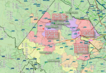
What happens when 3 structure fires get dispatched in short succession (Fairfax County, midday 25 June 2021)
Already occurring: gas leak in Reston at Market St & Explorer St (Box 425-41) with evacuations and HazMat (don't remember talkgroup).
1st fire: 2015 Kilgore Rd (Box 413-04), smoke in a rear bedroom (4D).
2nd fire: 13000 Farthingdale Dr (Box 436-03), fire on the second floor, quadrant B. RIT was dispatched (43D).
3rd fire: 6112A Arlington Blvd (Box 428-07), smoke from a power surge in the pump room of the swimming school (4F, command channel 4G).
Color key:
Black (e.g., FA425) = no units available
Pink (none shown) = at least 1 unit available, but no more than 10% of typical units
Purple (e.g., FA429) = no more than 25% of typical units
Red (e.g., FA404) = no more than 50% of typical units
Orange (e.g., MW303) = no more than 75% of typical units
Yellow (e.g., FA438) = no more than 90% of typical units
Green (e.g., FA402) = more than 90% of typical units
Blue (none shown) = more than 100% of typical units
Map is self-made in QGIS and shows fire stations, their units (self-researched on publicly-accessible sites), and their firebox's applicable coverage, according to how many units are in use.
The flag-type icons show the three active fires + the gas leak + some fill-in transfers, colored by determinant code (i.e., Delta level is red, Alpha level is green). Note: I do not know the actual dispatched calls so I made a guestimate as to the determinant codes for these incidents.


