Texas-New Mexico Power Company (TNMP)

BrokenCircuit

Member
Joined
May 13, 2025
Messages
30
Location
TexOkla
Good catch and that would jive with the activity. 14193 Region wide, 14202 local as its associated with the "Texoma" sites specifically. They've done their homework on how to build a system that works.
 

BrokenCircuit

Member
Joined
May 13, 2025
Messages
30
Location
TexOkla
Also, see this license: FCC Callsign WRYG298 (Texas New Mexico Power Company) as it ties in several locations.

Which brings me to what I have been wondering, are all the service regions tied together on the radio network? My suspicion is yes considering we have a talk group specified as "North Texas" TGID: 14193. I suspect the system is connected via internet since there are no Microwave licenses. OR they are using the Free microwave spectrum so many cheap fixed wireless ISP's use.

Additionally, I'm seeing more icall activity. So much more that I've programmed icall fulltime into the scanner (i0+Ente
 

mwjones

Member
Premium Subscriber
Joined
Apr 9, 2003
Messages
789
Location
Van Alstyne, TX
Texas New Mexico Power updated. I'm gonna need help on the ranges in general and centers for the simulcast areas. Only have circles to work with in RRDB.
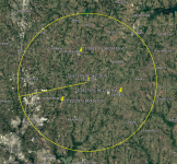
I'll get the centers and range approximations for you when I get an update ready - planning a "field trip" this weekend that will hopefully fill some holes, and when I do my normal template I have a website that takes the coordinates from multiple simulcast sites and calculates the geographic center (so for example the "Texoma" simulcast site is geographic centered at 33.4157N, -96.36219W), then I plot that on Google Earth and draw a radius circle to guestimate the range, based on output power of each of the sites. So, for "Texoma" I put conservatively at about 15 miles.

1749788498578.png
 

Russell

Texas DB Admin
Database Admin
Joined
Dec 18, 2002
Messages
1,871
Location
Dallas Texas
Wow, I've been manually calculating (estimating/maybe guessing) geographic centers. Love the website. I arbitrarily picked Trenton as the center for Texoma. Great job Mike and Tom, fantastic work!
 

mwjones

Member
Premium Subscriber
Joined
Apr 9, 2003
Messages
789
Location
Van Alstyne, TX
Wow, I've been manually calculating (estimating/maybe guessing) geographic centers. Love the website. I arbitrarily picked Trenton as the center for Texoma. Great job Mike and Tom, fantastic work!
The System is identifying as a Tait, "Texnoma" is site 1.5 on my screen, but I want to validate that while mobile (DSDPlus sometimes offsets site numbers +1, so it's either 1.4 or 1.5 but I'll do that verification with the SDS100). I also have the Channel ID's/LCN's for Texoma, but would like to validate with another site before saying I have the bandplan (which will calculate all the sites - but that means I'm logging live traffic, which may be hard to do on the weekend).

So far had hits on TG's 14193, 14198, 14202 and 14207 - hope to play through the recordings over the weekend and will combine anything I discover with the road trip data that I hope to collect tomorrow.
 

nd5y

Member
Joined
Dec 19, 2002
Messages
12,220
Location
Wichita Falls, TX
The old public version of DSD+ shows 1.2 and SDRTrunk shows 0.1. I don't know which is correct. I read something about SDRT subtracting -1 from system and site numbers.
SDRTrunk sometimes shows Brand: Tier III Trunking and sometimes Brand: Motorola Connect+. One of the event details the other day had something with Hytera. I don't know how to tell what it really is.
 

mwjones

Member
Premium Subscriber
Joined
Apr 9, 2003
Messages
789
Location
Van Alstyne, TX
The old public version of DSD+ shows 1.2 and SDRTrunk shows 0.1. I don't know which is correct. I read something about SDRT subtracting -1 from system and site numbers.
SDRTrunk sometimes shows Brand: Tier III Trunking and sometimes Brand: Motorola Connect+. One of the event details the other day had something with Hytera. I don't know how to tell what it really is.
The public version of DSDPlus is really old - about a year ago they overhauled the entire DMR Tier 3 stack in the Fastlane branch, so it's nothing like it used to be.

As far as I know the DMR support in SDRT is still "beta", and since I have a FastLane license for DSDPlus I've not really taken the time to play with SDRT and DMR (I use SDRT primarily only for observing LTR systems, just like I use Unitrunker only for monitoring Analog Motorola systems) since DSDPlus is much more mature.
 

mwjones

Member
Premium Subscriber
Joined
Apr 9, 2003
Messages
789
Location
Van Alstyne, TX
Quick update, have confirmed site numbers for Pilot Point and Rains County, and my field review of Texoma confirmed that DSDPlus is +1 on the Site ID's (According to my SDS100, Pilot Point is site 3, Texoma is Site 4, and Rains County is Site 6 compared to 1.4, 1.5 and 1.7 respectively on DSDPlus) - This warrants some more field work tomorrow (and likely Thursday, since it's a Federal Holiday and my work is closed, but I suspect the power company will be working).

I also hope if I do the field work on Thursday I can pick up some traffic and verify the bandplan, which will get the proper channel (LCN/LSN) assignments for each frequency. I've built a reliable model based on Texoma (which I can monitor constantly from home), and projected it out for each site, but I need a second site or a neighbor list (which this system so far isn't using) to verify it's accurate for all sites.

RRDB Updates being prepared for submission in the coming days.
 

nd5y

Member
Joined
Dec 19, 2002
Messages
12,220
Location
Wichita Falls, TX
SDRTrunk shows two types of channels, LCN and channel number for time slots.
For 0.1 Petrolia
451.425 LCN 114, Ch 229 S1, Ch 230 S2
452.3625 LCN 189, Ch 379 S1, Ch 380 S2
 

nd5y

Member
Joined
Dec 19, 2002
Messages
12,220
Location
Wichita Falls, TX
Alright, I'm confused on the sites numbers, now. Are there multiple regions?
I don't know about regions.
Different software shows different system ID (or network ID) and site numbers.

I "found" Pilot Point for the first time today.
Control Ch is 451.050 Color Code 0.
It's either site 0.3 or 1.4 depending on whether you believe SDRTrunk or DSD+.
I don't know which format is correct, which format DMR scanners use, if Uniden and Whistler are the same, and I don't know which format the database should use.

I also don't know if the LCNs and time slot channels shown in SDTRrunk are correct.
 

nd5y

Member
Joined
Dec 19, 2002
Messages
12,220
Location
Wichita Falls, TX
Can you get the MHZ Tier 3 system? What do those site numbers show?
I'm getting the Denton site 451.1625 weak with a lot of errors.
SDRTrunk shows
Brand: Hytera Tier III Trunking
Channel Type: Control
Color Code Timeslot 1: 3
Color Code Timeslot 2: 3
Network: 12
Site: 3
Network Model: LARGE
Tier III Neighbor Sites
Neighbor: Network:12 Site:2 LARGE LCN:1152 CHANID:2305
Neighbor: Network:12 Site:5 LARGE LCN:1152 CHANID:2305
Neighbor: Network:12 Site:6 LARGE LCN:3200 CHANID:6401

DSD+ shows
TIII Site:L13-1.4 DCC:3
Now its too weak and quit decoding before I could get the neighbors.

The database says
System is running CPS-P3 numbering scheme. (useful for DSD+ FL)
WTH is that?
 

Russell

Texas DB Admin
Database Admin
Joined
Dec 18, 2002
Messages
1,871
Location
Dallas Texas
Well, the site numbers match. The MHZ system has several sites that haven't been identified yet. Can you receive Decatur? Hopper owns MHZ.
 

nd5y

Member
Joined
Dec 19, 2002
Messages
12,220
Location
Wichita Falls, TX
I think I figured something out. If DSD shows L4-5.6 that means
Network type: Large
Network: 4
Region: 5
Site: 6
Right? In that case SDRTrunk does not show regions on TNMP or I'm not seeing all the data or I have something set wrong.
 

mwjones

Member
Premium Subscriber
Joined
Apr 9, 2003
Messages
789
Location
Van Alstyne, TX
Sorry for a lot of responses in one post:
SDRTrunk shows two types of channels, LCN and channel number for time slots.
For 0.1 Petrolia
451.425 LCN 114, Ch 229 S1, Ch 230 S2
452.3625 LCN 189, Ch 379 S1, Ch 380 S2
That matches my bandplan calculator spot on, that confirms that I have a valid bandplan (Base frequency 451.0125, step 12.5 KHz).
Alright, I'm confused on the sites numbers, now. Are there multiple regions?
Regions apply on a Tier III system if they go above 8 sites, so far we're under that.

DSDPlus on Standard Tier 3 systems (almost everything other than Motorola Capacity Max) increases the System ID, Region and Site ID by 1 each, so most tools report this system with System ID 0 and region 0, Sites 0-6, whereas DSDPlus says SystemID 1, region 1 and sites 1-7.

What we need is clarification from the leadership - since there is a RRDB downloader for DSDPlus config files, I would think we would follow the DSDPlus standard, lest we break the downloader, and I don't know of any scanners or other software that actively uses that information in their configuration.

As of today here's what I have for sites (in DSDPlus numbering region.site)

1.1 - Young/Jack County Simulcast
1.2 - Petrolia
1.3 - Montague County Simulcast
1.4 - Pilot Point
1.5 - Texoma Simulcast
1.6 - East Texas Simulcast
1.7 - Rains County Simulcast

Lewisville and Princeton have a DMR carrier, but no actual control channel on the air yet. Texoma was picked up in Princeton and Farmersville (and as far North as US 82, so my original coverage estimate was too conservative and will be revised in the upcoming submission.

I don't know about regions.
Different software shows different system ID (or network ID) and site numbers.

I "found" Pilot Point for the first time today.
Control Ch is 451.050 Color Code 0.
It's either site 0.3 or 1.4 depending on whether you believe SDRTrunk or DSD+.
I don't know which format is correct, which format DMR scanners use, if Uniden and Whistler are the same, and I don't know which format the database should use.

I also don't know if the LCNs and time slot channels shown in SDTRrunk are correct.
With a confirmed bandplan, Pilot Point should be LCN 84 and 97 for the two frequencies.

Can you get the MHZ Tier 3 system? What do those site numbers show?
DSDPlus reports SystemID L13, Region 1, Site 7 for Howe, the only one in range of my base, my SDS100 reports SystemID 12 and site 6.

I think I figured something out. If DSD shows L4-5.6 that means
Network type: Large
Network: 4
Region: 5
Site: 6
Right? In that case SDRTrunk does not show regions on TNMP or I'm not seeing all the data or I have something set wrong.
That is correct. If the region is 0, it is not sent over the air, which is why you would not see it in SDRTrunk. Motorola Capacity Max systems do not use a region, and with the latest versions of DSDPlus Fastlane all of the SystemID's and Sites on a Capacity Max system decode correctly.
 
Top