SDS100/SDS200: Vehicle install/setup

Status
Not open for further replies.

RobertI

Member
Joined
Sep 18, 2014
Messages
57
Location
US
Has anyone done a nice SDS100 vehicle install? You know, with part numbers of the items used, things like that.

It's been running fine so far, no cold solder issues yet. However it is far from a slick install. Scanner in a cup holder and an ugly wire that all keeps getting in the way of my iced coffee intake. This summer's project is a proclip-based mount with relatively easily detachable connections in the event I want to take it out.

My wish list is to have a nicely tucked remote roof antenna and ideally a right angle USB because having like an inch and a half of unbendable connector and wire sticking straight out to the right was not well thought out.

I have the SDS 100 Uniden GPS thing, for all the good it does 🙄, so it's mostly just for power.

Was looking at this, but don't know if the USB is wired differently. Thoughts?
USB B right angle pigtail

And suggestions for a remote antenna? Wire with correct connector and NMO antenna? I'm not afraid to pop another hole in the roof.

[Edit] just saw this thread, so I will digest it
Help Choosing An Antenna (SDS-100 - Vehicle)
 
Last edited:

nessnet

Member
Premium Subscriber
Joined
Jan 22, 2007
Messages
1,945
Location
Eastside of Lake WA
I have the SDS 100 Uniden GPS thing, for all the good it does 🙄, so it's mostly just for power.

I have to ask..... why do you say the above???
If GPS is set up and used correctly, (rectangles), it is the most useful feature Uniden puts into these radios.
I'd stick with the GPS, or cut the end off and solder up a right angle.
My 100 literally switches depts as I cross a state/county/city/rez border - completely automatically.
Very slick. Why would you not want that?

The belt clip pivot on the back of the radio fits into a traditional microphone clip for dash, etc. mounting.
 

RobertI

Member
Joined
Sep 18, 2014
Messages
57
Location
US
Oops! I meant mini. Undercaffeinated.

Some variation of these:
Mini USB 90
Mini USB 90 with pigtail

I agree, GPS IS a great thing, when it works properly. Even setting the range to 1 or 0 miles, it just isn't accurate...for me. I don't travel outside my normal route often so I gave up fiddling with it. It's the current firmware and database. No funny settings. Perhaps I just have a Friday night or Monday morning unit. I'll revisit it eventually.
 

nessnet

Member
Premium Subscriber
Joined
Jan 22, 2007
Messages
1,945
Location
Eastside of Lake WA
Oops! I meant mini. Undercaffeinated.

Some variation of these:
Mini USB 90
Mini USB 90 with pigtail

I agree, GPS IS a great thing, when it works properly. Even setting the range to 1 or 0 miles, it just isn't accurate...for me. I don't travel outside my normal route often so I gave up fiddling with it. It's the current firmware and database. No funny settings. Perhaps I just have a Friday night or Monday morning unit. I'll revisit it eventually.

GPS functionality is 100% in how you have it set up.
If set up properly it is VERY accurate.
(Not due to the "current firmware and database') per se....

The key is using rectangles, (vs. the much more inaccurate database's default circles), which does take some work, but transforms the GPS functionality and is well worth the effort..

Oh.... if you use any cord that does not have AWG24 power wires, you will get the low voltage error.
 
Last edited:

dave3825

* * * * * * * * * * * *
Premium Subscriber
Joined
Feb 17, 2003
Messages
8,510
Location
Suffolk County NY
The key is using rectangles, (vs. the much more inaccurate database's default circles), which does take some work, but transforms the GPS functionality and is well worth the effort..

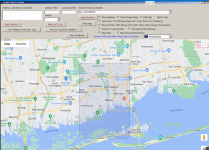
And while rectangles can be done via Sentinel, @ProScan software gives you the option to convert the circle to a rectangle and then view the visual rectangle on a map for adjusting.


1683047470959.png

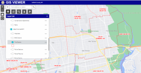
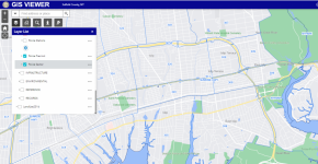
Many towns/counties/local governments have online GIS maps of the areas so you could get your rectangles pretty close. Mine has everything from fire dept boundaries down to each police precinct as well as each officers area of patrol.


1683047755542.png

1683048061256.png
 

RobertI

Member
Joined
Sep 18, 2014
Messages
57
Location
US
Rectangles. What magic is this? :ROFLMAO: You mean I shouldn't have burned the SDS in effigy?

Let's say I'm traveling from Massachusetts to Northern Maine, that's a heck of a rectangle. Do I draw a box over all of New England and call it "New England" in favorites?
 

dave3825

* * * * * * * * * * * *
Premium Subscriber
Joined
Feb 17, 2003
Messages
8,510
Location
Suffolk County NY
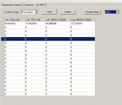
Circle is a circle but using one or more rectangles can let people define areas better. I am not sure the limit with the rectangles.


@ProScan can you advise on any limit there might be? I was able to add entry boxes for about 20.

1683049818097.png
 

avaloncourt

Member
Joined
Jun 10, 2011
Messages
167
I am not sure that cable will work on the SDS.
When I've made up cables in the past, I tried to start out by using commercial cables and couldn't use any I tried. I ended up having to buy connectors and making my own. I'm trying to remember which but I think it was Pin 2 at the USB connector wasn't wired in any of them.
 

ProScan

Software Provider
Premium Subscriber
Joined
Jul 2, 2006
Messages
7,805
Location
Ontario, Calif.
@ProScan can you advise on any limit there might be? I was able to add entry boxes for about 20.
I don't. You may be able find out by creating a rectangle then close the Favorites folder so the folder/files will be saved. Then using a text editor, search for a line starting with Rectangle. Copy and paste the line a hundred or two hundred times then open the Favorites Folder then write to the scanner. Then scan that system then read from the scanner to see if took.
 

nessnet

Member
Premium Subscriber
Joined
Jan 22, 2007
Messages
1,945
Location
Eastside of Lake WA
Rectangles. What magic is this? :ROFLMAO: You mean I shouldn't have burned the SDS in effigy?

Let's say I'm traveling from Massachusetts to Northern Maine, that's a heck of a rectangle. Do I draw a box over all of New England and call it "New England" in favorites?

No....
Basically, (the way I did it...), you organize all of your favorites by location.
Essentially, you define every dept or groups of depts by location.

Then define precise rectangles for each dept.
Sites, because of physics/RF propogation, remail circles.
Then, if done correctly, the radio automatically enables/disables depts as you travel from one jurisdiction to another.
Like I said... very slick.

You can even get as fine grained as defining individual patrol sectors, if you put enough work into it... :)
(Disclosure: engineer and major project PM, so a bit OC..... you can get deep into the geek here...)

As people have said above, you can use Proscan, but....
I was lucky (before it was gone) to have used a superb on-line tool that you put any jursdiction, (even reservations), into the search box and it popped out bounding boxes (rectangles). So, lots of cut/paste, but it really works quite well. I know there are still other on-line tools out there - Google is your friend.
 
Last edited:

RobertI

Member
Joined
Sep 18, 2014
Messages
57
Location
US
Somehow I never installed ProScan. Heard of it, meant to use it, just never did. Very nice software and am for sure buying the license.

The time to sit, learn, and fiddle is going to be tough. Is there a 10 minute course somewhere, ideally focusing on these magical rectangles?

[edit] Just read above. Oh boy, that's a serious undertaking. But that works for places you regularly go. What about traveling to NEW areas? I want to drive and explore and not have to sit for days programming rectangles of areas I "might" go. That's where I've found the uniden GPS is lacking in function, hence my badmouth.
 

nessnet

Member
Premium Subscriber
Joined
Jan 22, 2007
Messages
1,945
Location
Eastside of Lake WA
Somehow I never installed ProScan. Heard of it, meant to use it, just never did. Very nice software and am for sure buying the license.

The time to sit, learn, and fiddle is going to be tough. Is there a 10 minute course somewhere, ideally focusing on these magical rectangles?

[edit] Just read above. Oh boy, that's a serious undertaking. But that works for places you regularly go. What about traveling to NEW areas? I want to drive and explore and not have to sit for days programming rectangles of areas I "might" go. That's where I've found the uniden GPS is lacking in function, hence my badmouth.

Yea....
To do it correctly is alot of work.
(and.... ALWAYS!!! read before you write!!!!)

But.... as with any tech, alot of what you get out of it is the effort put into it.
It can also just be just top level and not as detailed as I have.
Just put some thought into it - where do I go regularly, and then explore the possibilities.

Like I said - by far, the best feature Uniden puts into these radios is GPS (IMO)
 

dave3825

* * * * * * * * * * * *
Premium Subscriber
Joined
Feb 17, 2003
Messages
8,510
Location
Suffolk County NY
Let's say I'm traveling from Massachusetts to Northern Maine, that's a heck of a rectangle. Do I draw a box over all of New England and call it "New England" in favorites?

Its more for defining geographic boundaries but You could do that if you want.

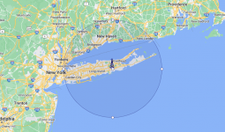
Here on Long Island, the MTA railroad pd district that covers Nassau and Suffolk Counties looks like this in the database using a circle..


1683054561584.png


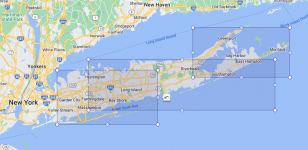
This is how it looks with just 3 rectangles. Can be more fine tuned with 4 or 5.

1683054378463.png


Looks much better than the default circle.


.
 

ProScan

Software Provider
Premium Subscriber
Joined
Jul 2, 2006
Messages
7,805
Location
Ontario, Calif.
Its more for defining geographic boundaries but You could do that if you want.

Here on Long Island, the MTA railroad pd district that covers Nassau and Suffolk Counties looks like this in the database using a circle..


View attachment 141137


This is how it looks with just 3 rectangles. Can be more fine tuned with 4 or 5.

View attachment 141136


Looks much better than the default circle.


.
Very simple way of explaining rectangles versus circles. Like they say, 'A picture is like a thousand words'
 

RobertI

Member
Joined
Sep 18, 2014
Messages
57
Location
US
It's a perfect illustration and makes total sense. My normal commute (50 or so miles) wouldn't be difficult to rectangle it. However, this still doesn't address my reason for the GPS. Plop me in the middle of Arizona and I want my GPS to tell me where I am and get the local sheriff's frequency. I mean, that's the whole point of the auto locate feature, right?
 
Status
Not open for further replies.
Top