Which Site for Ft Collins / Loveland?

Status
Not open for further replies.

soundchaser

Member
Joined
Dec 19, 2009
Messages
430
Location
Elevation 8308', Colorado
One thing for sure - I'm going to be looking into where that map data comes from. Especially with embedded elevation data, it's usually not cheap, much less free. They're being downloaded on the fly from somewhere.

I'm still trying to sort out how to get the internet copy of the requisite *.map file.

The problem is the documentation for the software is outdated. It's been around for nearly 10 years and continually improved upon. I used this tutorial here: Using Radio Mobile for Windows - Radio Mobile Tutorial as it's only 4 years old. ;) I didn't need a *.map file. When you go to generate the base map, you'll get a message that it can't find the map data. Click retry and it will download it.

Elevation data is public domain and paid for by our tax dollars. The program is using info collected by the Space Shuttle. I used MapQuest for the background roads, which limits the use for personal use only. But there is also an open source option for roads from within the program, but I didn't like that it shaded everything in the forest dark green.

I first learned about this program I think from the forums here on RR. So there might be some more info right here on this site.
 

ecanderson

Member
Premium Subscriber
Joined
Aug 27, 2009
Messages
518
Location
Colorado
But there is also an open source option for roads from within the program, but I didn't like that it shaded everything in the forest dark green.
Reminds me of what a newer Garmin handheld looks like with the DEM shading turned on. Things start to get dark and it can make the rest of a topo pretty hard to read. That said, it's still pretty clear where things are on the propagation map.
 

jeffreyinberthoud

Completely Banned for the Greater Good
Banned
Joined
Oct 18, 2001
Messages
1,880
Location
BERTHOUD COLORADO

soundchaser

Member
Joined
Dec 19, 2009
Messages
430
Location
Elevation 8308', Colorado
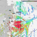
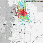
Horsetooth, Mead, and PVH, in that order. I also made some maps for Buckhorn and Prospect. I don't want to use up all of my attachment space on these maps. If anyone would a zip file mailed to them with all 7, send me your email in a PM.
 

Attachments

  • Horsetooth.jpg
    Horsetooth.jpg
    172.4 KB · Views: 77
  • Mead.jpg
    Mead.jpg
    236.5 KB · Views: 79
  • PVH.jpg
    PVH.jpg
    153.7 KB · Views: 77
Last edited:

ecanderson

Member
Premium Subscriber
Joined
Aug 27, 2009
Messages
518
Location
Colorado
That certainly demonstrates why PVH was a bust down here in Longmont. Ain't got no microvolts per meter here for sure. Looks as though perhaps their primary malfunction is lack of power vs. the terrain issues.
 

jeffreyinberthoud

Completely Banned for the Greater Good
Banned
Joined
Oct 18, 2001
Messages
1,880
Location
BERTHOUD COLORADO
That certainly demonstrates why PVH was a bust down here in Longmont. Ain't got no microvolts per meter here for sure. Looks as though perhaps their primary malfunction is lack of power vs. the terrain issues.


Im sure loveland DT will look the same heck I hardly get that from berthoud, although I do hear it from windsor
 

soundchaser

Member
Joined
Dec 19, 2009
Messages
430
Location
Elevation 8308', Colorado
That certainly demonstrates why PVH was a bust down here in Longmont. Ain't got no microvolts per meter here for sure. Looks as though perhaps their primary malfunction is lack of power vs. the terrain issues.

For simplicity, I made them all 100 watts, so I think it is terrain or buildings. The only thing that I varied from site to site was antenna height.

If you want a small footprint site, try Drake. It was about 5 pixels!

And I see that Horsetooth has a shadow over in Longmont.
 

soundchaser

Member
Joined
Dec 19, 2009
Messages
430
Location
Elevation 8308', Colorado
I bet someone here Radio tech wise can tell you wattages and so on

The database says 100W transmitting power for each site. The ERP varies widely for each site, but in my experiments with the maps, it makes very little difference. Terrain is the biggest issue. The only places that power will make a difference is at sites like Thorodin at 10,000 feet in elevation where there is pretty much an unobstructed view of the plains. Then power will make a difference in the overall distance, but not the pattern.

I will post the datafiles so that if anyone wants to open it the program and fool with the transmitting power or the uV scaling, they can.
 
Status
Not open for further replies.
Top