Angeles National Forest

Status
Not open for further replies.

DPD1

Member
Joined
Jul 24, 2005
Messages
1,994
They had a show on that showed a land slide in Japan where they did a similar thing. Crazy part was they actually predicted when the slide was going to happen down to 24 hours.

Dave
www.DPDProductions.com
Antennas & Accessories for the RF Professional & Radio Hobbyist
 

RobertW1

Member
Premium Subscriber
Joined
Nov 14, 2004
Messages
241
Location
Burbank, CA
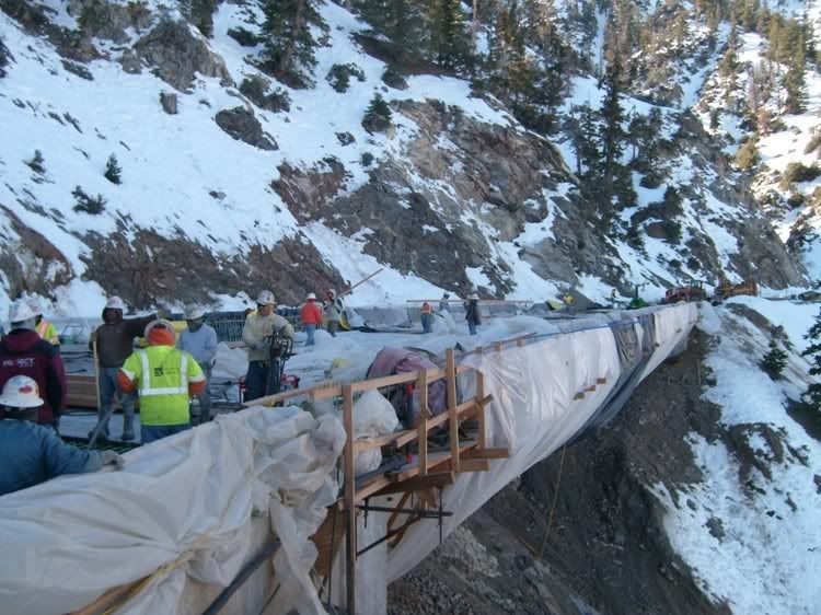
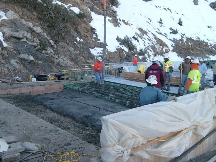
On January 2nd, 30 concrete trucks delivered, via CHP support, the concrete to complete pouring the bridge. The bridge has now been poured. They used pipes with hot water and warming blankets so as to keep the concrete warm and allow it to cure. Today the bridge has cured and they began pouring the aprons that connect the paved highway to the bridge itself.

By next Thursday they will be able to drive across the bridge. They will then begin pouring the cement guardrails and do the final touches. They also have a lot of construction material to be removed from around and underneath the bridge.

According to the CalTrans person I talked to, the Bridge will be ready in a couple of weeks. Will it open to the public before this upcoming Spring? That is yet to be determined.

Here the bridge is still covered in plastic to protect the newly poured concrete from the weather:


Bridge1.jpg


Here the "apron" is being poured:


Bridge2.jpg


Most of the construction material in the Vincent Gap Parking lot has been cleaned up and removed.
 

SCPD

QRT
Joined
Feb 24, 2001
Messages
0
Location
Virginia
Bob, a mutual friend of ours was here for a visit yesterday. I told him to say hi to you for me. He passed along that a party for the Grassy volunteers was quite successful.

I would bet that part of the decision to open the road will include the Angeles NF. I'm not sure what they think as this will bring additional traffic to the areas on both sides of the bridge. I think that Caltrans will have the major say in this decision as they have to now plow the entire road, something that they have not been doing for quite some time. Has it been three years or so?

Thanks for the pictures. Working on concrete in those conditions is pretty grim. I've done a little bit of it myself when essential gates have been run into during the winter. It is impossible to prevent that dreaded condition of cracked finger tips and oh that is so painful.

I understand the next project for this contractor will be the connection between SR 2 and SR 39. :wink:;)
 

RobertW1

Member
Premium Subscriber
Joined
Nov 14, 2004
Messages
241
Location
Burbank, CA
Bob, a mutual friend of ours was here for a visit yesterday. I told him to say hi to you for me. He passed along that a party for the Grassy volunteers was quite successful.

Fred, I got the "hello" from TC. Thanks! TC had a great time in Mammouth and told me he was able to spend a couple of hours talking with you. He gave me the good news that you are doing well with your injury recovery and that there is some light at the end of the tunnel regarding your wife's employment.

I would bet that part of the decision to open the road will include the Angeles NF. I'm not sure what they think as this will bring additional traffic to the areas on both sides of the bridge. I think that Caltrans will have the major say in this decision as they have to now plow the entire road, something that they have not been doing for quite some time. Has it been three years or so?

Actually CalTrans has had to plow the road between the construction site and Islip Saddle because they had been bringing in cranes and machinery from that side. Patrolling won't encompass much more work but will involve more mileage as there are only a few turnouts, a spring and one walkin campground on the PCT (Little Jimmy). But like you, I doubt there is any reason to open the road until next Spring. I wonder if there will be any fanfare. We are inundated with questions from bikers about when the road will open. We've had people come from Canada and even Europe to "ride the crest".

Thanks for the pictures. Working on concrete in those conditions is pretty grim. I've done a little bit of it myself when essential gates have been run into during the winter. It is impossible to prevent that dreaded condition of cracked finger tips and oh that is so painful.

Last weekend while the bridge was "curing" we came upon two workers sitting in a truck with the engine running and them sipping on hot cups of coffee. It was below freezing. Their only job was to watch over the bridge and make sure that the hot water kept doing what it was intended to do. They had people 24/7 watching the bridge while it cured. My only thought was that they aren't paying these guys enough money to watch the bridge in this type of weather. :eek:

I understand the next project for this contractor will be the connection between SR 2 and SR 39. :wink:;)

Oh, I hope not. They've poured millions of dollars in fixing that area over the decades. Some roads just shouldn't be repaired. Not to mention the impact to a large Big Horn Sheep population that inhabits that area.

In talking to these two bridge watchers I did find out that their company is also involved in a bridge being built in Glendale at the 134 and San Fernando Blvd. and the freeway improvements at Hollywood Way and the 134 in Burbank. :eek:
 
Last edited:

SCPD

QRT
Joined
Feb 24, 2001
Messages
0
Location
Virginia
Oh, I hope not. They've poured millions of dollars in fixing that area over the decades. Some roads just shouldn't be repaired. Not to mention the impact to a large Big Horn Sheep population that inhabits that area.

You didn't pick up on the winking my icons were doing in my post. The comment was strictly tongue in cheek. TC told me what it would take to reestablish the link. San Gabriel Canyon has enough use from one entrance, which aids in the management of the canyon. If there was another entrance it would complicate things greatly.
 

DPD1

Member
Joined
Jul 24, 2005
Messages
1,994
In talking to these two bridge watchers I did find out that their company is also involved in a bridge being built in Glendale at the 134 and San Fernando Blvd. and the freeway improvements at Hollywood Way and the 134 in Burbank. :eek:

I think your deal is going better... That thing in Burbank has barely budged for over a year.

Dave
www.DPDProductions.com
Antennas & Accessories for the RF Professional & Radio Hobbyist
 

DPD1

Member
Joined
Jul 24, 2005
Messages
1,994
I just happen to hear something going on up near Angeles Forest and Big Tujunga on the LASO citywide. I'm not sure what it is, but I noticed the reception from the units is just perfect. Why can't they give the forest service a system that works that good.

Dave
www.DPDProductions.com
Antennas & Accessories for the RF Professional & Radio Hobbyist
 

SCPD

QRT
Joined
Feb 24, 2001
Messages
0
Location
Virginia
I'm assuming you are talking about the LASO's two or three "county tacticals" or C Tacs as they are called. Citywide is a term used by the LAPD.

The Angeles NF has a pretty good system. You can't always hear the mobile units because when they can reach a remote base that has a microwave link they just talk simplex on channel 1 (simplex). If they can reach another unit on channel 1 for car to car they stay on simplex. If they can't reach the other unit or are out of range of a remote base they switch to channel 2 (repeater) and choose a tone for the repeater within their range. There are 14 or 16 repeaters on the Forest, which for a 690,000 acre National Forest is very good. My last Forest, the Inyo, is just short of 2,000,000 acres and nearly 170 miles north to south, in two mountain ranges, the Sierra and to the east the White/Inyo Mountains. We had 9 repeaters.

Field units cannot hear all the traffic for the entire Angeles NF and there are some real disadvantages to that. But the advantage is that they don't have to hear all the traffic and don't have to monitor it all while contacting the public and such. When the traffic is important they do hear it. On the Inyo National Forest we could hear almost all of the traffic for the north end of the Forest where visitors traveled between the north portion of the White Mountain Ranger District and all of the Mammoth and Mono Lake Ranger Districts. We could hear if Lee Vining or Rock Creek canyons had full campgrounds so that we did not tell people to go there when the Mammoth District campgrounds were full. We did not have to listen to the typical traffic about wilderness permits on the Whitney trail and the parking problems at Whitney Portal that were so far away that it did not affect anything we were doing on the north end. Thank goodness! If the Whitney Portal parking lot or Lone Pine Creek campground were full it did not affect anything we were doing on the Mammoth Ranger District, so why should we have to hear the radio traffic about it?

The feds don't use simulcast or multi cast repeaters like many counties and cities have. Forest Service radios must be able to work on various VHF federal radio systems around the country. When the Forest Service was tasked with debris recovery for the Columbia space shuttle tragedy, they had to operate on a number of different federal, state, county, and city VHF radio systems in Texas, Louisiana, and Oklahoma. The radios must have high channel capacity and the ability to be programmed on relatively simple radio systems. Even though they don't use digital almost 100% of the time their radios are required to have digital capability in case they have to interface with a federal agency that uses it. They can't use radios that would be able to work on many different protocols used by counties and cities.

The LASO uses UHF and UHF field radios are rare in federal natural resource agencies. Some agencies in the eastern U.S. use UHF exclusively, but most of the federal UHF band is utilized for linking in the Forest Service, BLM, National Park Service, U.S. Fish and Wildlife Service, and BIA. UHF is used for logistics and in camp use on large federal incidents, but not in the field.

As time goes on and funding is available, the Forest Service and National Park Service have been increasing the number of repeaters in National Forests and National Parks. This is the reason the standard tone list, shared with the state of California has increased to 16 tones. Increased numbers of repeaters indicates that jurisdictions are filling in as many dead spots as they possibly can.

Angeles fire units have a L.A. County Fire Department UHF radio in them and can communicate with them as needed. Many of the units monitor Blue 8 all the time and try to hear dispatches for anything that affects the Forest. The dispatch center at Fox Field does the same, but mostly relies on a computer that monitors the dispatches that L.A. County sends over MDT's. Being around an Angeles unit that is monitoring Blue 8 is really a pain, given all the beeping and constant dispatching. It would drive me nuts if I had to listen to that all the time. Fire units want to get the jump on the normal circuit between Fox Field and the LaCo fire dispatch center and that is why the monitor it much of the time. I have not hung out with anyone in law enforcement on the Forest in almost 25 years so I don't know if they have LASO radios in them. The LaCo fire units use VHF for fireground communications and can easily interface with the Angeles and most of the National Forests, Parks, and BLM jurisdictions in the state.
 

RobertW1

Member
Premium Subscriber
Joined
Nov 14, 2004
Messages
241
Location
Burbank, CA
We've finally learned to tell "Angeles Dispatch" which tone (repeater) we are on when going in and out of service. That way they can make sure they are responding via that repeater site. Before we used to do that, there were many times we would never hear them and just figured they were ignoring us. :eek:

It has been explained to us that Angeles dispatch is also responsible for dispatching for other agencies besides just the Angeles. They also dispatch for The Santa Monica Mountains National Recreation Area which is administrated by the National Park Service (Rumor has it that eventually the Angeles National Forest will become part of this recreation area). So, Angeles Dispatch can be very busy at times.

I hope to go there and get a tour in the near future. I'd like to put faces to the people I talk to on the radio.
 

RobertW1

Member
Premium Subscriber
Joined
Nov 14, 2004
Messages
241
Location
Burbank, CA
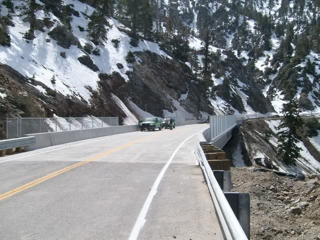
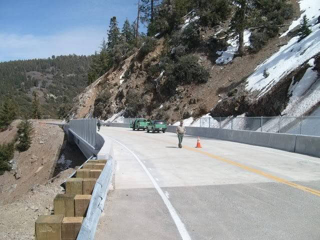
The bridge on Hwy 2 has been finished. Angeles Crest between Vincent Gap and Islip Saddle will open this next spring. The highway usually opens around Memorial Day Weekend.

FinishedBridge2-1.jpg


FinishedBridge1-1.jpg
 
Last edited:

RobertW1

Member
Premium Subscriber
Joined
Nov 14, 2004
Messages
241
Location
Burbank, CA
That is what I thought at first. A lot of that is an optical illusion as the fencing doesn't run the complete span of the bridge, just the steepest parts. You'll notice in the top picture the fencing is in two places on the hill side near the ends of the bridge.
 

DPD1

Member
Joined
Jul 24, 2005
Messages
1,994
Well, it will be one less place to worry about for sure. And now one of my monitoring spots will be open again.
 

DPD1

Member
Joined
Jul 24, 2005
Messages
1,994
Where is your spot, Dave? Or is this some secret squirrel stuff?

Honestly I don't even know the name, but there's a hwy. phone pull off that's east of where they had the road closed, and it looks out across the valley to the north. I think it's maybe 8k' there? Anyway, I've heard Nellis stuff there.
 

RobertW1

Member
Premium Subscriber
Joined
Nov 14, 2004
Messages
241
Location
Burbank, CA
Honestly I don't even know the name, but there's a hwy. phone pull off that's east of where they had the road closed, and it looks out across the valley to the north. I think it's maybe 8k' there? Anyway, I've heard Nellis stuff there.

It's called Dawson Saddle. There is a large turnout there with a CalTrans building. You have an unobstructed view of the entire Antelope Valley and can even see the southern portion of the Sierras. It is also a great location for monitoring Palmdale Airport, Edward's AFB and China Lake. I used to sit up there and do all my AM Military band monitoring. I'd listen to test pilots testing aircraft over the dry lake beds. I also could listen to aircraft over Mexico and Nevada. Nothing like sitting at 8,000 ft, on top of the world and sucking in radio transmissions for hundreds and hundreds of miles.

We've continue to patrol this area for the USFS even though it was closed. You will be very impressed with how nice the highway is. It is completely resurfaced and painted with new guardrails installed. It is hoped that it will be opened for the Memorial Day weekend, if not sooner. I'm sure there are going to be hundreds and hundreds of bikers making the run between Glendale and Wrightwod in the first week of its opening.
 
Last edited:

SCPD

QRT
Joined
Feb 24, 2001
Messages
0
Location
Virginia
It's called Dawson Saddle. There is a large turnout there with a CalTrans building. You have an unobstructed view of the entire Antelope Valley and can even see the southern portion of the Sierras. It is also a great location for monitoring Palmdale Airport, Edward's AFB and China Lake. I used to sit up there and do all my AM Military band monitoring. I'd listen to test pilots testing aircraft over the dry lake beds. I also could listen to aircraft over Mexico and Nevada. Nothing like sitting at 8,000 ft, on top of the world and sucking in radio transmissions for hundreds and hundreds of miles.

Thanks for identifying the spot. I remember the name. I would like to get up there sometime and work my PSR-600 mobile as well as my 2m/70cm gear. I was on top of White Mountain Peak northeast of Bishop many years ago and easily picked up traffic from the Las Vegas Ranger District (now the Spring Mountain National Recreation Area) of the Toiyabe National Forest. I didn't have any of the Utah NF frequencies with me as I never expected to be able to pick up things that far away so I didn't give it a try. Handheld scanners are so much better than they were in 1986 so I would bet taking the 96 up there would yield some great results.

I was on a several day trip in the Spring Mountains around 1985 for work purposes. I was on the Bridgeport Ranger District at the time and taking a look at Mt Charleston as it was a proposed wilderness. The output frequency of the Toiyabe is 169.875, which is the input frequency to the San Bernardino NF's Forest Net. I was picking up base, mobile, and handheld traffic from there on the handheld I wore on my belt. Just for kicks, I programmed in the San Bernardino Forest Net and hit a repeater or two, although at the time I did not have a list of the tones and repeaters for the San Berdo.

Back in the late 70's I was in the main building of Langmuir Laboratory at the National Thunderstorm Research Center on top of North Baldy Peak in the Magdalena Mountains just west of the Rio Grande Mountains in New Mexico. I took my BC-210 with me and set it up with the whip antenna on the counter in the observation room at the top of the lab building. I began to pick up mobile traffic on the Sitgreaves portion of the Apache-Sitgreaves National Forest in Arizona, in the Lakeside and Heber areas.

One of the neatest peaks to take radios up to and work is Mt. Diablo in the Bay Area. I had too short of time when I managed to drive up there some years back, but received Los Padres traffic on the Frazier repeater as well as Plumas and Shasta-T traffic.

I will add Dawson Saddle to my list of places to visit with a good frequency directory and several radios.
 

DPD1

Member
Joined
Jul 24, 2005
Messages
1,994
Thanks for the info... I don't recall a building though. I just remember you pull off and there's the emergency phone and some big trees on the left of the phone. But I'm sure it's the same basic area.

Farthest confirmed I got from there was a tanker at 325 miles away, but I'm sure there have been farther that I couldn't confirm. What's funny is you can get EDW ATIS from there, but not from about 3 miles NW of it. You can also hear RR detectors up into Tehachapi. Also a funny thing... I turned on an FRS and started talking to somebody who I think was working in a Home Depot or something down below. I told them where I was and they just thought I was BSing them so they stopped talking. One time I was going to go there and somebody was going to go way out to Lancaster or something and see if we could read each other, but we didn't end up going. I've done about 14 miles on regular FRS though, so I think it's possible.

Only problem is I seem to have some new thing where I start getting sick at higher altitudes. Last time I was up there I got it.
 

SCPD

QRT
Joined
Feb 24, 2001
Messages
0
Location
Virginia
Dave,

It sounds like you need to acclimate as you increase in elevation, not do it all at once. You also need to be fully hydrated, enough so that you have to pee about once per hour. In Mammoth one of the most common EMS calls is for people driving up here, skiing their first day, and then not drinking enough water combined with drinking some coffee and/or dark soda such as Coke, Pepsi, etc. These last drinks are diuretics and result in a net loss of water in the body. Your body loses more moisture at higher elevations than at lower elevations, even when it is cold. These people present symptoms of nausea and light headiness to the point they pass out. I've been in restaurants for dinner twice where someone passed out nearby.

I assume your symptoms are light headiness or a headache, and perhaps some nausea. The headaches can be murder. Altitude sickness is difficult to predict based on a person's acclimation and physical condition. In 1983 I had worked primarily at my desk and did not get into the field very much. My wife had been on two long backpack trips, one over Forester Pass, which at 13,000+ feet is the highest pass in the Sierra. On Labor Day weekend we climbed White Mountain Peak, which is only 250 feet or so lower than Mt. Whitney, i.e. 14,300 feet or so. My wife became nauseous, and lightheaded, enough that she was disoriented enough that I had to push her down the trail. After we descended about 2,000 feet she came out of it. Funny stuff that altitude can cause.
 
Status
Not open for further replies.
Top