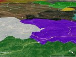
I've searched for all the CHP maps, and I've even tracked down some of the old ones, but it is time for a new one using modern technology and I'm in the process of drawing one for the whole state. Here's how you can help: Post everything you know about where channel switch points are on the major highways. I'll start...
17 at the Santa Cruz/Santa Clara County line, Green on the south side, Ruby 2 on the north
85 at Cottle Road is the switch from Green to Ruby 2
101 at Blossom hill is the switch from Green to Ruby 2
1 at the Santa Cruz/San Mateo line is the switch from Green to Amber 2
101 at the San Mateo/San Francisco county line is Amber 2 to Pink
1 at the Santa Cruz/Monterey county line is Green to Black
80 is Gray 2 all the way from the Nevada/California border almost to Auburn, where it turns to Green 3, but I'm not sure of the exact exit where this happens
Etc.


