Howard County Police updated beat map

Status
Not open for further replies.

blee1099

Member
Joined
Jun 23, 2003
Messages
98
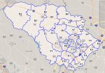
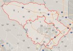
Was listening to the scanner after getting home from being out of town for work for the last month. After listening I noticed some changes to their police beat and was able to check their GIS system and yup it has changed. Baker beat is now out west and north of I-70, adam beat is east along 100 to 95, etc..
 

Attachments

  • beatmap.jpg
    beatmap.jpg
    350.4 KB · Views: 104

blee1099

Member
Joined
Jun 23, 2003
Messages
98
Sure do miss your feed.
I've been thinking about bringing it back but just don't have the time to keep it up & running. The hardest part was when I was traveling for work and having no one there to reboot the server or the scanner. Maybe I'll bring it back one day. I figured you had a scanner capable of listening.
 

sc800

Active Member
Joined
Aug 29, 2007
Messages
632
How are they breaking up ND and SD now?

Beats C,D,E now cover what were two separate districts and I don't see a clear line between the two
 

blee1099

Member
Joined
Jun 23, 2003
Messages
98
How are they breaking up ND and SD now?

Beats C,D,E now cover what were two separate districts and I don't see a clear line between the two
It's really confusing to look at now. Parts of Elkridge are district 1 and parts of it are district 2. Everything south of 100 is district 2 and it appears 95 separates district 1 & 2 for Charlie & Frank beats.
 

Attachments

  • police district.jpg
    police district.jpg
    314.9 KB · Views: 26

sc800

Active Member
Joined
Aug 29, 2007
Messages
632
That is an interesting breakdown. Although it does take away some of the confusions from before. (I.e. West of 29 108 separated ND and SD but East of 29 the separation was 175)
 
Status
Not open for further replies.
Top