2021 Arizona wildfire season

Status
Not open for further replies.

es93546

A Member Twice
Premium Subscriber
Joined
Aug 18, 2020
Messages
1,333
Location
Right Side of CA on maps
PHD-455 Tussock UPDATE 2
for those playing at home....

A/G Secondary = 167.1750
LOG RPT IN = 168.100
LOG UHF link = 406.5875

When you note that you logged the UHF link, what traffic was it carrying NIFC Command 2 (168.1000 is the input to C2)? 406.5875 can also be configured as a logistics net repeater (L2) without linking anything.
 

es93546

A Member Twice
Premium Subscriber
Joined
Aug 18, 2020
Messages
1,333
Location
Right Side of CA on maps
PHD-455 Tussock
Type 1 team in place this evening.
Rotor Freq 134.025
New A/G 169.925 not in use yet

From Inciweb: "Southwest Type 1 Team 2, led by Incident Commander Dave Bales, assumed management of the Tussock Fire this morning." When teams travel during the day, they usually don't take command until the next morning. In fact, Type 1 and Type 2 teams almost always take command for day shift. They will usually join the evening plans meeting as a way to get briefed by the outgoing day shift. The outgoing or replaced management team has the responsibility for the next day's day shift IAP. The next morning they are then briefed by the outgoing night shift. The first IAP they assemble is then for that evening's night shift. Sound complicated, but it isn't. Actual command passing is at 0600 the morning after they arrived the afternoon and evening prior and they don't put their planning section, ops section, etc. until that time.

Your abbreviation "LOG" can have two different meanings. It can indicated you logged the frequency and weren't there to hear it or it can be inferred as being used for logistics. It would be helpful it we knew which it is. It could also mean you logged it and heard it, both.

Size is now given as 3,500 acres. Looks like it has crossed the PNF boundary a very short distance. Most of the fire is on BLM and state deeded land. I don't know the details, but AZ DFFM and the BLM must have agreements in place designate one agency in charge of areas with mixed BLM/state ownership. They probably do this using criteria of who has the most land in various zones and where the BLM has critical or sensitive resource values, such as wilderness areas, threatened and endangered plant and wildlife habitat and designations such as Areas of Critical Environmental Concern, national monuments, etc. It also might involve the locations of BLM fire stations and field offices. The state also has responsibility for all lands outside fire districts, but those lands might be delegated to the feds per cooperative agreements.

When I worked in the southwest, both in Arizona and New Mexico circa 1973-1981 such agreements were not in place. One day in New Mexico I was home sick and listening to the scanner of course. There was a fire near Mt. Taylor. The Cibola National Forest, some an indian reservation and some private land all come together in that area as I recall. I might have been the BLM instead of an indian reservation, but I don't think they had a helo. The Cibola sent its helicopter from stationed on the Sandia Ranger District, either the Northern or Southern Pueblo Agency sent a helo and NM State Forestry sent one also. Each agency was responding with engines and crews without coordinating with each other. I don't know if each agency had been called by the public to report the fire, or if someone from each agency spotted it. I thought 3 helos in one area might not be too safe. Apparently none of the three had scanners in their dispatch centers and neither did any one in the field. I was tempted, but did not assert myself by calling the Cibola dispatcher to let them know the various agencies needed to figure out who was in charge before they all ended up at the same fire. I was in the beginning of my career and didn't want to look like I wanted to run someone else's function. Later on I didn't care about such things, if it was wrong someone was going to hear from me. I don't remember how the situation was resolved, I just remember shaking my head at the circus that was occuring. I assume that this type of situation has been resolved/planned for by now, they have had 40 years since to work it out.
 
Last edited:

radioprescott

Member
Premium Subscriber
Joined
Dec 24, 2003
Messages
506
Location
East Central Arizona
@es93546

LOG = Logistics; CMD = Command

So I heard them testing this morning on 170.450 , calling it "Logistics". I turned on my other radio and tracked down 168.100 with the same traffic and CTCSS. The third radio (yeah I know) is scanning the known NIFC cache freqs, and hit on 406.5875. Its the same traffic on all three.

They are calling170.450 'Command 9' on the radio (likely based on the channel slot in the IC405 which I haven't seen yet). Techs are testing now and I'm hearing same traffic on VHF and UHF link. (The tech at ICP also is hearing himself on the UHF link). [The whole conversation started because one tech heard a lot of carriers "kerchunking" and was checking to see if someone was having trouble hitting the repeater]

The techs talking also mentioned CMD 8 as a simulcast of CMD 9, but I haven found it yet.

FYI: I may use a 'logger' (Proscan to be specific), but I don't rely on just the loggings or recordings to post. I'll use the logs to find potential freqs, but I only post what I hear and can verify. So I 'verified' the channel names based on actual traffic heard.
 

radioprescott

Member
Premium Subscriber
Joined
Dec 24, 2003
Messages
506
Location
East Central Arizona
Yep, off going ATGS uses 122.925. to brief oncoming. Unfortunately its also a Lake Pleasant area advisory freq for flight practice , so I don't have it in my scan list.
 

es93546

A Member Twice
Premium Subscriber
Joined
Aug 18, 2020
Messages
1,333
Location
Right Side of CA on maps
@es93546

LOG = Logistics; CMD = Command

So I heard them testing this morning on 170.450 , calling it "Logistics". I turned on my other radio and tracked down 168.100 with the same traffic and CTCSS. The third radio (yeah I know) is scanning the known NIFC cache freqs, and hit on 406.5875. Its the same traffic on all three.

They are calling170.450 'Command 9' on the radio (likely based on the channel slot in the IC405 which I haven't seen yet). Techs are testing now and I'm hearing same traffic on VHF and UHF link. (The tech at ICP also is hearing himself on the UHF link). [The whole conversation started because one tech heard a lot of carriers "kerchunking" and was checking to see if someone was having trouble hitting the repeater]

The techs talking also mentioned CMD 8 as a simulcast of CMD 9, but I haven found it yet.

FYI: I may use a 'logger' (Proscan to be specific), but I don't rely on just the loggings or recordings to post. I'll use the logs to find potential freqs, but I only post what I hear and can verify. So I 'verified' the channel names based on actual traffic heard.

Another curious procedure. 170.4500 output and 168.1000 input is NIFC Command 2. VHF is not set up for logistical traffic. There are 7 UHF frequency pairs for logistics repeaters.

I use Proscan for my 325P2, but I use GRE PSR-500/600 scanners most of the time. I use the Starrsoft software to log traffic on the PSR-600 base station that is connected to a rooftop antenna. I plan to rework my station so that I have 4 scanners hooked up to the same antenna, but have been dragging my feet on the project. I'm 70 now and retired, that is, I was tired yesterday and I'm tired again today.

When I listen to a fire I can have 4 radios on. I might use my Kenwood TH-6 (my preferred ham handheld) for VHF AM listening, a scanner on the NIFC system, one for forest, park or BLM nets and one for tacticals. Sometimes I step out a second story window and walk up to the peak of the roof. My wife hands me a shopping bag with the 4 radios, binoculars and a clipboard so I can keep track of details. Sometimes I add a GMRS radio so my wife can find out what I am seeing and hearing. Pretty soon members of our CERT team (my wife is a member) or friends start calling us to find out the news. 5 radios can get to be a little much!
 

es93546

A Member Twice
Premium Subscriber
Joined
Aug 18, 2020
Messages
1,333
Location
Right Side of CA on maps
Tussock Fire

Two Superscoopers now working the fire as of 1540. Scooper 263 and Scooper 261.

We used to call them "pooper scoopers" as they have all this razzle dazzle, sexiness with the media and public, but then only drop water, not retardant. Every load of retardant is worth at least 20 loads of water. With Lake Pleasant as close as it is they might be able to do some good. I learned how to water ski on that lake. It must be at a reduced level or I don't remember, is it tied into the CAP?
 

Giddyuptd

Member
Premium Subscriber
Joined
Oct 6, 2018
Messages
1,358
Location
Here and there
Speaking of region 3,
R3 TAC 1 167.550
R3 TAC 2 168.675
R3 TAC 3 168.775

These replaced the 3 common tacs in a main zone I forget what they were labeled
 

GlobalNorth

Active Member
Premium Subscriber
Joined
May 2, 2020
Messages
2,345
Location
Fort Misery
Is the CAP connected to Lake Pleasant? Yes. The CAP pumps water into the lake as a storage vessel during the fall and winter months and is released in the summer. The remaining water comes from hydrogeologic runoff from the Agua Fria River.
 

wupatki

Member
Joined
Dec 19, 2002
Messages
29
Location
Arizona
Scoopers SCPR261 and SCPR263 are working Primary A/G on 168.400 while on station today.

I drove out to the lake earlier just in time for them to head back to Falcon for fuel. Now 90 minutes later they're back. There's also a fire command city setup at Ben Avery on Carefree Hwy. There's at least two dozen tents, lots of support vehicles and food trucks there.
 

es93546

A Member Twice
Premium Subscriber
Joined
Aug 18, 2020
Messages
1,333
Location
Right Side of CA on maps
Is the CAP connected to Lake Pleasant? Yes. The CAP pumps water into the lake as a storage vessel during the fall and winter months and is released in the summer. The remaining water comes from hydrogeologic runoff from the Agua Fria River.

When I was living in Arizona Lake Pleasant was fed by the Agua Fria only. I left Arizona at the end of 1977.

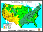
Now something wildland fire related. The fuel moisture levels most closely watched by fire managers are the "1,000 hour fuels." These fuels are 3-8" in size. These are fuels that both spread somewhat rapidly and produce a great deal of heat, adding greatly to the intensity of a fire. The 1,000 hours or 41.7 days means that it takes that long for the fuels to fully react to the moisture levels around it in the soil, air and adjacent fuels. These fuels will remain dry and only slowly react if the moisture levels rise due to precipitation or conversely will remain wet until a lack of precipitation dries them out. Below is a map of the existing 1,000 hour fuel moisture:

1000 hour moisture.png

Let's put this in perspective. Most of us are familiar with Douglas fir lumber. It is used when strength is needed. The best 2 x 4's are often of this species. We are also familiar with ponderosa pine lumber. This is the species used for a lot of lower cost dimensional lumber, often used for shelving and comes in 1" x 4, 6, 8, 10 and 12" widths. What does that have to do with fuel moisture you say? The end of the lumber milling process is to dry lumber in a kiln. Lumber is then slated for shipment to lumber yards, Home Depot, Lowes, etc. Douglas fir is shipped at a moisture level of 15%. Ponderosa pine is shipped at 12-19%. So when you see the dark red, the 3-8" fuels have less than 5% moisture. The orange color indicates 6-10% moisture and the yellow, 11-15% is about the moisture level of lumber arriving at the retail outlets you buy lumber from, if it isn't sitting out in the rain, is very humid or encountered significant precip along the way.

The black triangles indicate the location of Remote Automatic Weather Stations (RAWS). All weather, including fuel moisture, is recorded at these stations. Look at how much territory in the southwest U.S. has fuels this size where the moisture level is at or below kiln dry lumber levels. Also note that these fuels are not going to gain and equalize with their surroundings for just shy of 6 weeks.

Here is where the data for each RAWS site, as shown on several map products, are listed.

RAWS Data List

Two RAWS locations in Arizona are showing 11% 1000 hour fuels, one is located at Reds Lake, near Tonalea, just southwest of the prominent landmark of the "Elephant's Feet" on U.S. 160, the "Four Corners" or "Navajo Trail" highway. The other is the "Hilltop" RAWS, which is nearby. For some reason the map is showing a moisture level of 16-30%+. This is an obvious error.

You will notice that the 10 hour and 100 hour moisture levels are also shown. These are the more "flashy fuels" or those that cause rapid spread. They are also the fuels, especially the 10 hour, where a lot of fires are ignited. They are the 1/4-1" fuels and the 100 hour are 1-3" size. Maps are also available for these fuels as well. Fuel moisture and other data are used to calculate the daily fire danger levels you see posted on signs and shown in the media. There is more to the actions taken in reaction to fire danger by public agencies than meets the eye.

For those who would like to read into this more, see this site:

Wildland Fire Assessment System

There is a lot of information here and this is a lengthy post. I hope some of the fire buffs on RR will at least bookmark and follow the 1,000 fuel moisture. It indicates how the fire season is winding up or down.
 
Last edited:

es93546

A Member Twice
Premium Subscriber
Joined
Aug 18, 2020
Messages
1,333
Location
Right Side of CA on maps
Scoopers SCPR261 and SCPR263 are working Primary A/G on 168.400 while on station today.

I drove out to the lake earlier just in time for them to head back to Falcon for fuel. Now 90 minutes later they're back. There's also a fire command city setup at Ben Avery on Carefree Hwy. There's at least two dozen tents, lots of support vehicles and food trucks there.

I guess that really nice skeet course is closed. I imagine a sleeping area is located there as well.

The reason scoopers don't perform well, is they drop their loads at relatively higher elevations and greater speeds, as compared with helos (rotary wings). When fixed wings drop water the loads often break up and much of it can evaporate prior to hitting the ground. I've observed loads that completely evaporate before reaching the target. In these circumstances one load of retardant is worth more than all the water a scooper can drop in a whole day. Factors such as terrain and fuel height (primarily trees) affect the drop as well, which governs how low any of the aircraft can fly. Retardant is like a viscous gel when it drops, so evaporation is far less of a factor. This gel characteristic is why fire lingo is used to say "we got snotted on" by firefighters when a drop reaches them. The lower and slower an aircraft drops from, causes the load to increase in "snottiness." Water is effective when it is dropped from a lower elevation and slower travel speed, which is what helicopters do. The drops are more effective as they can be precisely located. A good pilot can sometimes drop on target so well that days of mop up can be saved. Also spot fires and hot flare ups can be knocked down in a way water dropping fixed wings don't accomplish as well.
 

AZDon

Member
Joined
Feb 10, 2014
Messages
244
Location
Flint Michigan
5/12/2021 8:30 PM the following frequencies are patched. 415.5875, 170.45, 406.5875 and 170.6875. My location is the far north end of Peoria.
 

Azgunguy

Member
Premium Subscriber
Joined
Jun 2, 2015
Messages
106
Location
Scottsdale, AZ
I’m gonna be doing some boat work up at pleasant today and right next to our lot is where helos will be landing. Any chance on being able to listen to their comms? If so what freq?
 

AZDon

Member
Joined
Feb 10, 2014
Messages
244
Location
Flint Michigan
VTAC 11 151.1375 seems to be carrying wild land fire traffic. Previously mentioned patch is still active.

171.50 active and doesn’t seem to be patched.

VTAC 17 161.85 active, could be fire related.

151.4 active

171.5 Active Helicopter just landed as a precaution due to a engine failure light. 7:47 AM

Fire is contained and aircraft might not be required today.
 
Status
Not open for further replies.
Top