CHP frequency use map, corrections needed

Status
Not open for further replies.

inigo88

California DB Admin
Database Admin
Joined
Oct 31, 2004
Messages
2,017
Location
San Diego, CA
Oakland "Bronze" - Northern Boundary?

I believe the Bronze extends all the way north of Alameda county into Richmond to the Richmond-San Rafael Bridge toll plaza, and then northeast into San Pablo. I'm trying to keep an eye on where the Bronze (Oakland) stops and the Maroon (Contra Costa) begins.

I would also like to keep an eye on northwestern San Francisco, to see if the area of Hwy 1 (S.R. 1) / 19th Ave falls under the jurisdiction of the Pink (San Francisco) or Violet (Marin) offices.

Thanks!

Inigo
 

DPD1

Member
Joined
Jul 24, 2005
Messages
1,994
Is Malibu/PCH really part of west valley? Because I don't think I've ever heard a single PCH call on theirs.
 

KMA367

Member
Premium Subscriber
Joined
Nov 21, 2002
Messages
1,040
Location
Redwood Coast, N Calif
Is Malibu/PCH really part of west valley? Because I don't think I've ever heard a single PCH call on theirs.
Well, from the LASD website, it kind of looks like LASD Malibu/Lost Hills does traffic enforcement and collision investigation within the incorporated cities of Agoura Hills, Calabasas, Hidden Hills, West Hills, and Westlake Village, but there's a lot of unincorporated pieces mixed in between those cities throughout the hills between 101 and PCH.

At the moment (Mon, 0342) there's a "filed incident" on CHP's CADWEB page being handled by Ventura CHP, "0442D0719 - 10:02PM - Traffic Collision - No Injuries YERBA BUENA RD AT PACIFIC COAST HWY" which is about 1½ miles west of Malibu's west city limit on PCH, so that answers the area west of Malibu.

To its east there's only about a ½-mile gap between LAPD's area on PCH at Coastline Dr and Malibu City limits near Topanga Canyon Blvd. I guess we'll have to listen in or watch CHP's LA Comm Center 'http://cad.chp.ca.gov/resources.asp?resource=filed&DispatchIn=LACC' for both West Los Angeles and West Valley CHP calls, as well as Ventura Comm Center "http://cad.chp.ca.gov/resources.asp?resource=filed&DispatchIn=VTCC" filed incidents, or their active stuff at the main CHP Traffic Incident Information Page
 

KMA367

Member
Premium Subscriber
Joined
Nov 21, 2002
Messages
1,040
Location
Redwood Coast, N Calif
I would also like to keep an eye on northwestern San Francisco, to see if the area of Hwy 1 (S.R. 1) / 19th Ave falls under the jurisdiction of the Pink (San Francisco) or Violet (Marin) offices.

Thanks!

Inigo
Wouldn't that area be in EssEffPeeDee's Richmond District's jurisdiction, as that page seems to be saying? And Taraval Station south of Lincoln Way to the City/County line. Would seem that their Traffic Company would handle most or all traffic stuff all through there since it's a surface street within city limits. Other than things like school bus crashes and the like.
 

DPD1

Member
Joined
Jul 24, 2005
Messages
1,994
At the moment (Mon, 0342) there's a "filed incident" on CHP's CADWEB page being handled by Ventura CHP, "0442D0719 - 10:02PM - Traffic Collision - No Injuries YERBA BUENA RD AT PACIFIC COAST HWY" which is about 1½ miles west of Malibu's west city limit on PCH, so that answers the area west of Malibu.

That one makes sense, because that's a couple miles into Ventura Co. I guess it would kind of make sense if west valley handled the Malibu part, since LASD is kind of setup the same way. But I'll keep an eye on their page.
 

KMA367

Member
Premium Subscriber
Joined
Nov 21, 2002
Messages
1,040
Location
Redwood Coast, N Calif
Halfway up Topanga is West Valley's, anyway

That one makes sense, because that's a couple miles into Ventura Co. I guess it would kind of make sense if west valley handled the Malibu part, since LASD is kind of setup the same way. But I'll keep an eye on their page.
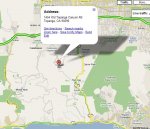
OK, here's an incident from this morning, showing West Valley CHP handling at least to the approximate midpoint between 101 and PCH:
10:19AM Traffic Hazard 1454 OLD TOPANGA CANYON RD West Valley
1454 Old Topanga Canyon Rd, Topanga, Los Angeles, California 90290 - Google Maps

BTW, a good friend and former CHP ditch-patcher tells me that the "Area" column, such as "West Valley" in this case, indicates the area office in whose jurisdiction an incident occurs, whether they have to assign it to an out-of-area car or not. E.g., if there's a crash on 101 in North Hollywood and no W Val units are available they may assign it to a Central LA unit, but the CAD will still show it as a West Valley call.
.
 

Attachments

  • 1454OldTopangaCHP-WVal.jpg
    1454OldTopangaCHP-WVal.jpg
    78.7 KB · Views: 2,066
Last edited:

KMA367

Member
Premium Subscriber
Joined
Nov 21, 2002
Messages
1,040
Location
Redwood Coast, N Calif
"N/B 101 at Golden Gate Bridge" is MARIN (at least partly)

I would also like to keep an eye on northwestern San Francisco, to see if the area of Hwy 1 (S.R. 1) / 19th Ave falls under the jurisdiction of the Pink (San Francisco) or Violet (Marin) offices.
Active (at 12:43) incident "Traffic Collision - No Details Location: NB US101 AT GOLDEN GATE BRDG", but details say "PER BRG - VEHS MOVED TO VISTA POINT."

So at least part of the bridge is Marin's. Just a guess, but since south of the bridge is most likely SFPD's area, and a Marin unit going to a "northbound" call would likely have to go all the way across the bridge and turn around anyway, maybe they've given the whole bridge to the Marin area. Or is that too logical?
 
Last edited:

JT-112

Member
Joined
Jan 11, 2004
Messages
497
Hmmmm.... been to Vista Point quite a bit, and IIRC (I may not) I thought there was some sort of access offered to go back northbound by going under the bridge there.

Looking at Google Earth, there is just such a road but it looks a bit sketchy and there may be a gate on it Doesn't look to be something used all that much.
 

DPD1

Member
Joined
Jul 24, 2005
Messages
1,994
OK, here's an incident from this morning, showing West Valley CHP handling at least to the approximate midpoint between 101 and PCH:
10:19AM Traffic Hazard 1454 OLD TOPANGA CANYON RD West Valley

I guess for some reason I was assuming CHP handled most of the PCH stuff, when it might be LASD. I have heard LASD on PCH many times. But I could swear I've seen CHP making stops along PCH Malibu in the past, and I know they're the guys that handle filming on PCH. I've heard Altadena up in ANF numerous times, but just don't remember hearing west valley on PCH. Of course it would be a lot more easy hearing the mobile side. That will be nice when it happens.
 

KMA367

Member
Premium Subscriber
Joined
Nov 21, 2002
Messages
1,040
Location
Redwood Coast, N Calif
Huntington Dr & San Gabriel Bl - CHP ALTADENA

This map has a different color (blank?) north of East L.A. and west of Baldwin Park, with Temple City in it. What area office is this supposed to be in?
and

That blank area near Temple City would include the unincorporated areas of East Pasadena and North San Gabriel. If I recall correctly East Pas was covered out of Altadena and San Gab areas were covered by BPK.
Call on CAD right now for a "Traffic Collision - No Injuries HUNTINGTON DR AT S SAN GABRIEL BLVD - Altadena" So it should be on the Brown. Don't know what this area would technically be called... could be either E Pasadena or N San Gabriel county area.
Huntington Dr & S San Gabriel Blvd, San Gabriel, CA - Google Maps

Huntington-SanGabriel-AltadenaCHP.jpg
 

KMA367

Member
Premium Subscriber
Joined
Nov 21, 2002
Messages
1,040
Location
Redwood Coast, N Calif
I guess for some reason I was assuming CHP handled most of the PCH stuff, when it might be LASD. I have heard LASD on PCH many times. But I could swear I've seen CHP making stops along PCH Malibu in the past
Yeah, it surprised me, too, but almost all those cities are relatively recently (last 18-25 years) incorporated, see http://ceo.lacounty.gov/forms/09-10 cities alpha.pdf - Malibu (3/91) and Calabasas (4/91) are the two newest cities in the county, so CHP did traffic there until LASD took it off their hands, and there could have been some time before LASD got the various cities' traffic contracts inked.

Also, with all the unincorporated pockets still belonging to CHP, they pretty much have to spend a lot of time on PCH and the Canyon roads just going to and from calls. Lots of opportunities to write tickets as they're passin' thru.
 

KMA367

Member
Premium Subscriber
Joined
Nov 21, 2002
Messages
1,040
Location
Redwood Coast, N Calif
Did anyone ask how Tracy came up with his map? (freqofnature.com)
I don't know how Tracy got it, but a CHP dispatcher familiar to us from yahoogroups told me in 2007 that the map was custom made by a "friendly DOT fella" in Los Angeles but "there aren't others like it in electronic form." There was an officer willing to make others, but that was way down on his list of things to do. Obviously it still is. Or maybe the officer's retired.
 
Last edited:

KMA367

Member
Premium Subscriber
Joined
Nov 21, 2002
Messages
1,040
Location
Redwood Coast, N Calif
1172 Encinal Cnyn, off Decker Cnyn is CHP WEST VALLEY (Teal)

CHP West Valley is handling a crash, Hit and Run - No Injuries -1172 S ENCINAL CANYON RD - West Valley. this is about 22 driving miles farther southwest from yesterday/s crash on Old Topanga, and getting close to the Ventura County Line at PCH.

This makes it appear that the West Valley/Teal area as shown on Pete's map is accurate for the Malibu area.
 
Last edited:

KMA367

Member
Premium Subscriber
Joined
Nov 21, 2002
Messages
1,040
Location
Redwood Coast, N Calif
Unincorp Malibu area does belong to CHP West Valley

Is Malibu/PCH really part of west valley? Because I don't think I've ever heard a single PCH call on theirs.
One more new incident that I think pretty well cinches up the entire unincorporated area around Malibu as part of CHP's West Valley/Teal area:

-Traffic Collision - Ambulance Responding

ENTRADA RD JNO N TOPANGA CANYON BLVD - West Valley"(C)"


CHP-WVal-inMalibu.jpg


The City of LA/LAPD area starts just to the east of this Entrada/Topanga call (C), along the diagonal line that marks the west boundary of Topanga State Park.
 
Last edited:

DPD1

Member
Joined
Jul 24, 2005
Messages
1,994
One more new incident that I think pretty well cinches up the entire unincorporated area around Malibu as part of CHP's West Valley/Teal area:

Yep... Good work. I guess I need to open my ears more. I'm actually interested in the rural areas a lot more than the city, so it would be cool to hear that stuff.
 

jrholm

Member
Joined
Aug 22, 2006
Messages
585
Location
Big Bear
and

Call on CAD right now for a "Traffic Collision - No Injuries HUNTINGTON DR AT S SAN GABRIEL BLVD - Altadena" So it should be on the Brown. Don't know what this area would technically be called... could be either E Pasadena or N San Gabriel county area.
Huntington Dr & S San Gabriel Blvd, San Gabriel, CA - Google Maps

Huntington-SanGabriel-AltadenaCHP.jpg

Right there would be called East Pasadena (unincorporated). Just south of Huntington would be considered North San Gabriel (unincorporated). At least that's how it was called by LASD, even though they are covered by the same beat car out of Temple Station (51)
 

gman65

Member
Premium Subscriber
Joined
Jul 15, 2005
Messages
68
Location
Woodland Hills, CA
Updates?

Just wondering if there has been an update to the map yet. I know there has been a lot of responses. Please advise when it is available. Great Job!
 

Radio_Lady

Member
Joined
Feb 19, 2006
Messages
474
Location
Off the Air
Unanswered boundary ?'s, East Bay

I believe the Bronze extends all the way north of Alameda county into Richmond to the Richmond-San Rafael Bridge toll plaza, and then northeast into San Pablo. I'm trying to keep an eye on where the Bronze (Oakland) stops and the Maroon (Contra Costa) begins.
I'll gladly help keep an eye on the East Bay areas on their CAD page, but I'm not very familiar with the geography. Approximately where, as in offramps, are the county lines along I-80, 580, 680 and Hwy 24? Or better yet, which parts of those areas are in question? I'm pretty good at driving maps, but neither of my online favorites, Google and Bing, show the county lines or city limits like Thomas Bros. Too bad there's no map for that area like the one for L.A. County CHP on the freqofnature.com site. There was a post in the last day or two on the SoCalScan y-group that the L.A. map was one of a kind, drawn by by someone at CalTrans apparently for the LA CHP dispatchers or officers.

Let me know where I can help.

RL
 
Last edited:

WayneH

Forums Veteran
Super Moderator
Joined
Dec 16, 2000
Messages
7,541
Location
Your master site
Passing this 3rd party:

Borders of the Bronze:

richmond san rafael bridge toll plaza @ 580
estudillo @ 580
appian way @ 80
davis @ 880
caldecot @ 24
bay bridge toll plaza @ 80

Borders of the Aqua:
(Where it does not meet the Bronze)

580/205 split
crow canyon @ 680 (?)
dixon landing @ 880
scott creek @ 680
 
Last edited:
Status
Not open for further replies.
Top