Official BCD996T Prerelease Thread

Status
Not open for further replies.

STiMULi

Member
Joined
Nov 14, 2004
Messages
1,566
Location
Tucson, Arizona
Found in the PreLim manual:

Note: Always use 50- or 75-ohm, RG-58, or RG-8, BNC terminated coaxial cable
to connect an outdoor antenna. If the antenna is over 50 feet from the scanner, use
RG-8 low-loss dielectric coaxial cable. Cable loss increases with higher frequency.

Keep those frequencies low or you will be buying new cable all the time.

Where does lost cable go? :)
 

STiMULi

Member
Joined
Nov 14, 2004
Messages
1,566
Location
Tucson, Arizona
From the PreLim manual:

Location-Based (GPS) Scanning

The BCD996T can make use of data transmitted from an attached GPS unit that
lets the radio automatically enable and disable systems based on the geographic
information you provide such as:
• Latitude (the center of the range)
• Longitude (center of the range)
• Range (the radius of a circle around the latitude and longitude coordinates
selected from .5, 1, 3, 5, 10, 20, 30, and 50 miles.
You set the longitude and latitude to approximate the center of a geographic entity
such as your local city and set the range to encircle that center point. By doing so
you set aside reception of an adjacent city that otherwise might be undesirably
received from one extremity of your city.
In addition, all geopolitical areas are not perfect circles. Therefore you can
accommodate these variations by entering multiple sites for the system, eve
though the system actually has one site, and use different location settings for
each of those additional sites.
See the programming section for specific steps required to apply location data to a
radio system.

Setting Site Location Information

[MENU] Program System
Select a trunked system
Edit Site (current)
Select a site
Set LocationInfo
This setting control whether the system is automatically enabled and disabled
when you connect a GPS to the scanner.

Latitude — Enter the system’s latitude using the format you selected in the
system settings.
Set Longitude — Enter the system’s longitude using the format you selected in
the system settings.
Set Range — Set the system’s range using the units you selected in the system
settings.
Set GPS Enable — Depending on the data received from the GPS, the L/O
status of the site is automatically controlled.
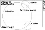
Use the attachment below:

Based on my understanding of the GPS programming I can program the individual 5, 7 and 20 mile coverage areas by using the center points and choosing a range that exceeds the coverage area.

When it comes to monitoring the county I would have to setup multiple systems to cross the county using 2 x 30 mile ranges to emulate a rectangle.
If want to monitor state highway patrol I could not realistically use the Location based scanning unless I lived near enough to a stateline to use a range.

Am I on the right track?
 

Attachments

  • example.JPG
    example.JPG
    39.9 KB · Views: 619
Last edited:

UPMan

In Memoriam
Premium Subscriber
Joined
Apr 19, 2004
Messages
13,296
Location
Arlington, TX
If it is a trunked system, you can set up the 5/7-mile areas as seperate sites on the system. For conventional, you would have to set up seperate systems.

If want to monitor state highway patrol I could not realistically use the Location based scanning unless I lived near enough to a stateline to use a range.

I really don't know what you are trying to say here. You can put the center of a zone at any arbitrary location...geopolitical boundaries don't matter to the GPS or scanner (just to the listener).
 

josephdavis13

Member
Joined
Feb 11, 2004
Messages
159
Location
Austin Texas
What Type of GPS Unit With BCD996T

What type of economical GPS Units can I buy to connect or use on the BCD996T scanner. Brand names would helpful.

Thank You

Joseph
 

oregontreehugger

Member
Premium Subscriber
Joined
Jun 5, 2004
Messages
1,282
Location
PNW
I prefer Garmin. Specifically the eTrex Legend. About $150 now I believe, and it comes with a pre-loaded useful basemap. Also comes with a GPS->serial port cable.

Magellen also makes quite a few small, low cost GPS units. There are also a few other companies out there.

Some people like Garmin, some people like Magellen. It's a Ford versus Chevy debate.

Take a look at this informative web site: www.gpsinformation.net
 

Jay911

Silent Key (April 15th, 2023)
Feed Provider
Joined
Feb 15, 2002
Messages
9,378
Location
Bragg Creek, Alberta
I'm one of those Garmin fans. I have a GPS60CS in my truck and it feeds Garmin or NMEA data to my laptop for a number of various purposes. If you want a device that will do *nothing else* than supply position information to the 996, then I wonder if you might want to consider the GPS 18, which is a standalone GPS with an RS232 serial cable and NMEA output.
 

josephdavis13

Member
Joined
Feb 11, 2004
Messages
159
Location
Austin Texas
I have tried to read all the previous posts about BCD996T scanner using GPS devices. However a lot of this information and posts are all over. Frankly and honestly I am not sure too sure what type of GPS I will really need for the BCD996T scanner. What advantages will I have with certain types or models? Can you enlighten me on what types of GPS will give me certain features and capabilities with this scanner.

Thank you,

Joseph
 

Jay911

Silent Key (April 15th, 2023)
Feed Provider
Joined
Feb 15, 2002
Messages
9,378
Location
Bragg Creek, Alberta
To the best of my knowledge, the scanner is doing all the work, once it receives the numerical position information from the GPS. So all you need is something that can send the position info to the scanner. The GPS18 I mentioned above is literally a little hockey puck on a magnet and has no user interface, display, etc., it just plugs directly into a computer and keeps sending position information. Nothing could be simpler in my opinion, if the 996 is the only reason you're getting a GPS.
 

RocketNJ

Member
Joined
Feb 1, 2003
Messages
1,041
Location
Pequannock, NJ
While we are on the subject of GPS receivers, can anyone suggest a GPS that is used for vehicle navigation (turn by turn voice prompts) with serial NMEA183 output for use with the 996? I think the Garmin Street Pilot III Deluxe would work but the mapos are a few years old by now.
 

STiMULi

Member
Joined
Nov 14, 2004
Messages
1,566
Location
Tucson, Arizona
STiMULi said:
If want to monitor state highway patrol I could not realistically use the Location based scanning unless I lived near enough to a stateline to use a range.

UPMan said:
I really don't know what you are trying to say here. You can put the center of a zone at any arbitrary location...geopolitical boundaries don't matter to the GPS or scanner (just to the listener).

1st if all let me say that I am not complaining I am just trying to understand it all and simplify my ultimate goals...

Arizona is a B I G state. I travel all over the state on a fairly regular basis. I also travel into the bordering states. What I am looking for is a way to travel from one state to another and have the scanner recognize (within reason) that I have crossed state lines.

From how I understand the way that this all works is:

1) Location based scanning works on the basis of a circle
2) The maximum diameter of any circle is 50 miles
3) The user enables/disables the systems in association with the circle size and location and whether the user is entering them or exiting them.

Arizona's extreme dimensions are 392 mi from north to south and 341 mi from east to west.

If I were to include all of DPS Highway patrols freqs in to one system I would have to duplicate that system about 56 times (a grid of 8x7) to get full coverage of the state.

Things I could do to to lessen this would be to choose roads or areas that I would more likely be traveling and only program those system locations or reduce the systems to the Divisions that are in certain areas. I could also just recognize that I am exiting one state and entering another at that point manually enabling or disabling the systems . The latter defeats the usefullnes of the Location based scanning.

I would like to see the final product allow ranges up to 500 miles (.5, 1, 3, 5, 10, 20, 30, 50, 100, 250, 500 miles) I have not been in areas that are so saturated that they would need a resolution of .5 or even 1 miles for the purposes of Location based scanning.

I see a future upgrade to the product or product line that would allow the uploading of "Maps". I have a tracking (not navagational) alarm system in my car that uses both circles and squares/rectangles for alerting of border crossing. I could see this as a useful feature in the BCD996T in the implememtation of POI and LBS.

I would be very interested in seeing a "map" of a beta testers unit in how they use the LBS for the areas they monitor.
 
Last edited:

STiMULi

Member
Joined
Nov 14, 2004
Messages
1,566
Location
Tucson, Arizona
oregontreehugger said:
I prefer Garmin. Specifically the eTrex Legend. About $150 now I believe, and it comes with a pre-loaded useful basemap. Also comes with a GPS->serial port cable.

For the money (eBay has great prices on the Legend) is a great deal. I use it for APRS. I wish the screen were a bit larger though.
 

Jay911

Silent Key (April 15th, 2023)
Feed Provider
Joined
Feb 15, 2002
Messages
9,378
Location
Bragg Creek, Alberta
RocketNJ said:
While we are on the subject of GPS receivers, can anyone suggest a GPS that is used for vehicle navigation (turn by turn voice prompts) with serial NMEA183 output for use with the 996? I think the Garmin Street Pilot III Deluxe would work but the mapos are a few years old by now.

I am not familiar with the StreetPilot III Deluxe, but my 60CS has taken map updates from City Select 5 thru 7 without any problems. Just buy/download the updated maps from Garmin and stuff 'em in there.

If the SPIII doesn't take map upgrades via software/cable, any new/modern GPS will.
 

RocketNJ

Member
Joined
Feb 1, 2003
Messages
1,041
Location
Pequannock, NJ
Thanks for the feedback regarding GPS receivers. The 276C seems to be the closest to what I am looking for. Auto navigation is the primary function with NMEA serial out as a secondary.
 

mam1081

Member
Feed Provider
Joined
Dec 19, 2002
Messages
1,103
Location
Next to a scanner...
STiMULi said:
1st if all let me say that I am not complaining I am just trying to understand it all and simplify my ultimate goals...

Arizona is a B I G state. I travel all over the state on a fairly regular basis. I also travel into the bordering states. What I am looking for is a way to travel from one state to another and have the scanner recognize (within reason) that I have crossed state lines.

From how I understand the way that this all works is:

1) Location based scanning works on the basis of a circle
2) The maximum diameter of any circle is 50 miles
3) The user enables/disables the systems in association with the circle size and location and whether the user is entering them or exiting them.

Arizona's extreme dimensions are 392 mi from north to south and 341 mi from east to west.

If I were to include all of DPS Highway patrols freqs in to one system I would have to duplicate that system about 56 times (a grid of 8x7) to get full coverage of the state.


I think I'm going to just not include the GPS ability on my banks for conventional highway patrol. I'll just have to remember to turn the bank on when crossing the state line. Can you imagine how many banks Texas would take? or CA? or AK (- wait I think they are trunked)!?!
 

STiMULi

Member
Joined
Nov 14, 2004
Messages
1,566
Location
Tucson, Arizona
mam1081 said:
I think I'm going to just not include the GPS ability on my banks for conventional highway patrol. I'll just have to remember to turn the bank on when crossing the state line. Can you imagine how many banks Texas would take? or CA? or AK (- wait I think they are trunked)!?!


Hence my hope that the final product or an upgrade includes a range of up to 500 miles. :)
 
Status
Not open for further replies.
Top