Sticky Thread For Mid-Atlantic MilAir 2022

Status
Not open for further replies.

JetWash

Member
Joined
Sep 3, 2021
Messages
230
Location
Fairfax, VA
I've also put together sector charts showing boundaries and frequencies. One of these days I want to transcribe the sector boundaries (lat/long) onto Google Earth as well.


View attachment 131534
I've never been able to find anything about sector boundaries. The FAA does have a file on ARTCC boundaries, but nada on sectors. Did your info come from the FOIA request you mentioned a couple of weeks ago? Thanks, and good listening.
 

jsoergel

Member
Premium Subscriber
Joined
May 14, 2009
Messages
2,130
Location
Cincinnati/Dayton, OH
I've never been able to find anything about sector boundaries. The FAA does have a file on ARTCC boundaries, but nada on sectors. Did your info come from the FOIA request you mentioned a couple of weeks ago? Thanks, and good listening.
Sector boundaries are hard to come by. I did get a few official documents from a friend who works at ZKC, but most of the ones I found were from VATSIM (simulator) hobbyists and their ARTCC sector files. They are usually close enough.
 

Bearcat15

Member
Joined
Mar 30, 2010
Messages
70
Location
Long Island, NY
I've never been able to find anything about sector boundaries. The FAA does have a file on ARTCC boundaries, but nada on sectors. Did your info come from the FOIA request you mentioned a couple of weeks ago? Thanks, and good listening.
I found these for ZNY and ZBW, I haven’t found much for ZDC. I haven’t looked for any other sector maps though.
ZNY (Issued 07/17/2022): https://notams.aim.faa.gov/lta/main/viewlta?lookupid=2881532156306265635
ZBW (Issued 12/16/2021): https://notams.aim.faa.gov/lta/main/viewlta?lookupid=2719897123687503303
 

AirScan

Member
Premium Subscriber
Joined
Feb 13, 2007
Messages
3,027
I've never been able to find anything about sector boundaries. The FAA does have a file on ARTCC boundaries, but nada on sectors. Did your info come from the FOIA request you mentioned a couple of weeks ago?

Yes they are published (both maps and lat/long) in most Center SOPs that I obtained using an FOIA request. You can also try contacting the Centers directly using snail mail, most are happy to provide them, although one snarky reply from ZID said it was none of my business (You can find an older version here in the ARTCC wiki). Still looking for a list of Center e-mail contacts. The NOTAMS published by ZBW and ZNY (Bearcat15s post above) are a good basic reference, but these are the only 2 Centers I've seen that do this. Send me a PM if you want and I can give you more info.
 

wbagley

Active Member
Premium Subscriber
Joined
Dec 3, 2004
Messages
1,632
Location
Near Louisville, Kentucky
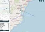
1835- Maris 35 (E-6B # 162782 VQ-4 Det) coming off the Atlantic on VA/DE border. Probably heading to PAX. Departed from Tinker AFB.

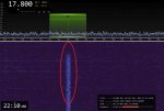
MARIS 53 took a turn out to sea over Norfolk, Virginia and did some VLF TACAMO work for a couple of hours. Narrow, wide and medium bandwidth signals seen here in Kentucky on the customary Atlantic frequency of 17.8 kHz.

MARIS 53.jpg17.8 29.jpg
 

RaleighGuy

Member
Premium Subscriber
Joined
Jul 15, 2014
Messages
14,965
Location
Raleigh, NC
Folks out Michigan way get a couple days of CAP work perhaps starting Monday.
Maybe Ohio F-16's will cover that one? Toledo not far off.
2/6486 NOTAM Details (faa.gov)

Couple days? TFR only active about 6 hours on Tuesday. Hadn't heard about Monday.


From (November 29, 2022 at 1330 EST)
To (November 29, 2022 at 1900 EST)
 

RaleighGuy

Member
Premium Subscriber
Joined
Jul 15, 2014
Messages
14,965
Location
Raleigh, NC
I know what I'll be watching next Friday, the unveil of the B-21 Raider on December 2, 2022.

 
Status
Not open for further replies.
Top