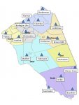
Is there a map or chart available which shows the locations of the antennas/repeaters in the county? For the new system of course.
You are using an out of date browser. It may not display this or other websites correctly.
You should upgrade or use an alternative browser.
You should upgrade or use an alternative browser.
Burlington County 700 MHz Project 25 TRS
- Thread starter elias1988
- Start date
- Status
- Not open for further replies.
Click on the FCC Callsigns link right above the site listings. That will show you all licensed sites for the entire system.Is there a map or chart available which shows the locations of the antennas/repeaters in the county? For the new system of course.
If you want to see the licensed sites for each cell, click on the site name, then click the little
Keep in mind that those site maps are based purely on the FCC license data, so if that's not accurate or up to date, neither will the mapping be. We have no control over that, obviously.
Thanks. Just tried and the FCC side is down for mntnce.Click on the FCC Callsigns link right above the site listings. That will show you all licensed sites for the entire system.
If you want to see the licensed sites for each cell, click on the site name, then click the little View attachment 90102 icon on the Site FCC Licenses line just above the listed call signs.
Keep in mind that those site maps are based purely on the FCC license data, so if that's not accurate or up to date, neither will the mapping be. We have no control over that, obviously.
I wasn't able to navigate to what I wanted.
Did you follow my directions? It's all right there, as detailed.I wasn't able to navigate to what I wanted.
Now I see where you wanted me to go to. Thanks for your time.
Hello people, I have the new Burlington County emergency services proprammed into my sds 100 and it working pretty good, although I am in Burlington County. My question is I see all response talkgroups, but I didn't see any fire ground channels. I know they must have them. Any help on that matter and are you able to receive them county wide? Thanks for any info.
Firegrounds are 700MHz simplex (off the TRS). You have to be within 2.5 miles of the site to hear them (that's the range my friend in Medford got when doing portable-to-portable testing over flat ground).
Terrain around here is thick with trees. I could barely here a fire ground channel when they were less than a mile from my house using a discone 40 ft up. You need to be close in to hear them. The 500 MHz fire ground channels definitely propagated better.
Where might I find those 'fireground' channels? I don't see them in the new or old system?
Just heard TGID 3215 is tied together now. Could hear the fire co side clear but not the chopper side at all.
phillydjdan
Member
- Joined
- Jan 27, 2011
- Messages
- 2,075
Those 500 MHz simplex channels are not longer used. The reason the new 700 simplex channels aren't listed is they haven't been discovered yet by us.
This is the list of the low power regional/nationwide 700 MHz frequencies available for use as on-scene/fireground channels. Note that analog is permitted on these frequencies, one of the rare exceptions in the 700 MHz band, so they may not be exclusively P25 (see Camden County).
769.00625
769.01875
769.03125
769.04375
769.05625
769.06875
774.93125
774.94375
774.95625
774.96875
774.98125
774.99375
769.00625
769.01875
769.03125
769.04375
769.05625
769.06875
774.93125
774.94375
774.95625
774.96875
774.98125
774.99375
Yes, they are still using it. Just heard another dispatch a second ago. I've been voiding the channel lately.
For the Burlington County new system. Does anyone have the UIDs to program into the SD100 / SDS200? I started manually entering them. Be quicker if someone has a hard copy to just enter. Thank you
Anyone notice today that Central was doing radio checks with Mercer County? Up to R7 that I heard.
- Status
- Not open for further replies.
Similar threads
- Replies
- 1
- Views
- 495
- Replies
- 13
- Views
- 2K


