Duke Energy P25 is coming alive in NC

IcomIcR20

Member
Premium Subscriber
Joined
Jun 16, 2014
Messages
836
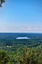
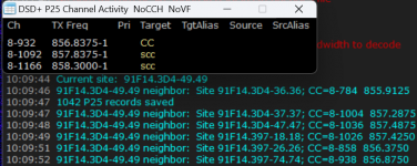
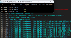
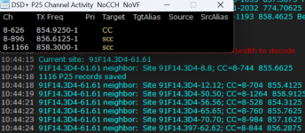
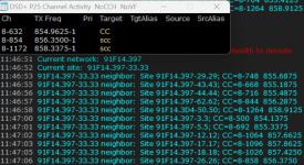
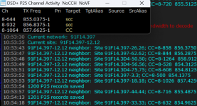
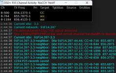
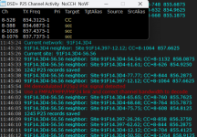
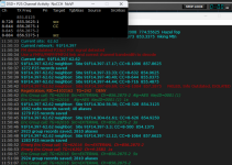
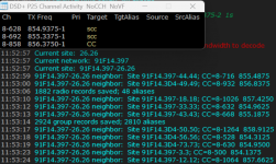
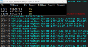
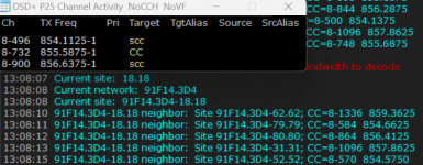
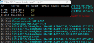
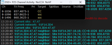
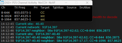
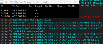
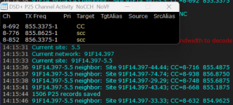
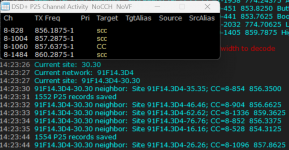
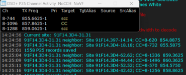
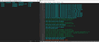
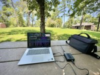
Always glad to help map out some new systems. Turns out Morrow Mountain in Stanly county is an excellent location for receiving 800 MHz sites ranging from Charlotte almost over into Raleigh! Most of these sites were received using an SDR connected to a Radio Shack 800 MHz HT antenna and laptop set up on a park bench at the summit. I verified a few of the SC sites while getting gas in Wallace, SC and snagged the Winecoff site while passing through Kannapolis, NC. Fun stuff!

@mtindor I can always make a formal submission using the information from the DSD+ text file. That is what I have done in the past, I believe. However, if it is not incontinent for you to use the screenshots I posted in this thread, then you are more than welcome to use those! That would be a bit easier on me since screenshots cannot be submitted, as you pointed out. Either way is fine by me.
 

mtindor

OH/WV DB Admin
Database Admin
Joined
Dec 5, 2006
Messages
10,817
Location
Carroll Co OH / EN90LN
Always glad to help map out some new systems. Turns out Morrow Mountain in Stanly county is an excellent location for receiving 800 MHz sites ranging from Charlotte almost over into Raleigh! Most of these sites were received using an SDR connected to a Radio Shack 800 MHz HT antenna and laptop set up on a park bench at the summit. I verified a few of the SC sites while getting gas in Wallace, SC and snagged the Winecoff site while passing through Kannapolis, NC. Fun stuff!

@mtindor I can always make a formal submission using the information from the DSD+ text file. That is what I have done in the past, I believe. However, if it is not incontinent for you to use the screenshots I posted in this thread, then you are more than welcome to use those! That would be a bit easier on me since screenshots cannot be submitted, as you pointed out. Either way is fine by me.

I will link to the screenshots. that is not a problem. If you decide you want to submit text at some point, just submit all the sites in one submission. But I'll add the sites based off of the screenshots so you can avoid a submission if you like. Not a problem for me to do it like this.
 

RaleighGuy

Member
Premium Subscriber
Joined
Jul 15, 2014
Messages
14,242
Location
Raleigh, NC
I will link to the screenshots. that is not a problem. If you decide you want to submit text at some point, just submit all the sites in one submission. But I'll add the sites based off of the screenshots so you can avoid a submission if you like. Not a problem for me to do it like this.

I know you are in Ohio @mtindor and want to say thank you for your help and interest in the NC part of the system, since day one you and @IcomIcR20 have gone above and beyond. Unfortunately, the summer months are my busiest at work and I've slacked off, but haven't forgotten the project.
 

mtindor

OH/WV DB Admin
Database Admin
Joined
Dec 5, 2006
Messages
10,817
Location
Carroll Co OH / EN90LN
I know you are in Ohio @mtindor and want to say thank you for your help and interest in the NC part of the system, since day one you and @IcomIcR20 have gone above and beyond. Unfortunately, the summer months are my busiest at work and I've slacked off, but haven't forgotten the project.

Always glad to help cheerlead. But down in the Carolinas i wasn't very effective. It was you, @IcomIcR20 mostly sleuthing, with a couple of others who sleuthed some sites. I just created a map. Useful, but not without anyone looking at it :) I appreciate you guys carrying monitoring equipment and traveling all of the place to find these sites. I didn't do that hear in Ohio and is something I could never have done. I have a lot of appreciation for those who blow their time / money to sleuth this stuff out!
 

IcomIcR20

Member
Premium Subscriber
Joined
Jun 16, 2014
Messages
836
I have a lot of appreciation for those who blow their time / money to sleuth this stuff out!
A perk of being in college is having summer/winter breaks that allow me some free time to go traipsing around the southeast when I am not working. It is a bit amusing trying to explain to my parents where I am disappearing to for the day, but they are always supportive even if they do not fully understand what I mean when I say I am "going to look for Duke Energy sites" :LOL:

But anyways, I second RaleighGuy in thanking you for all your hard work in getting this system efficiently entered into the database. Much appreciated!
 

mtindor

OH/WV DB Admin
Database Admin
Joined
Dec 5, 2006
Messages
10,817
Location
Carroll Co OH / EN90LN
17 sites added to the DB. And there were a few sites added to the wiki (previously unknown, currently not confirmed) that were discovered based upon the neighbor lists.

If I fudged anything up, and I may have after 3 hours of sleep, let me know.

For the Charlotte area sites, I've been adding some additional location -- such as Charlotte (Hood Rd), Charlotte (Research Drive), Charlotte (Duke Energy Plaza).

Thanks!
 

RaleighGuy

Member
Premium Subscriber
Joined
Jul 15, 2014
Messages
14,242
Location
Raleigh, NC
@mtindor @IcomIcR20 all changes made I think except google earth update. If anyone notices anything I missed shoot me a dm and I'll fix it.

My database of licenses are both corrupt and can't pull new FCC data using the Site download, so unable to update or rebuild Google Earth at this time.
 

spacellamaman

Member
Joined
Aug 22, 2014
Messages
1,374
Location
municipality of great state of insanity
Always glad to help map out some new systems. Turns out Morrow Mountain in Stanly county is an excellent location for receiving 800 MHz sites ranging from Charlotte almost over into Raleigh! Most of these sites were received using an SDR connected to a Radio Shack 800 MHz HT antenna and laptop set up on a park bench at the summit. I verified a few of the SC sites while getting gas in Wallace, SC and snagged the Winecoff site while passing through Kannapolis, NC. Fun stuff!

@mtindor I can always make a formal submission using the information from the DSD+ text file. That is what I have done in the past, I believe. However, if it is not incontinent for you to use the screenshots I posted in this thread, then you are more than welcome to use those! That would be a bit easier on me since screenshots cannot be submitted, as you pointed out. Either way is fine by me.
Morrow Mountain is THE place to be for long-range piedmont receiving, Pineland rx, VaSTARS, Blue Ridge Parkway, etc, not just frequency ranges 800-900, all sorts. It was somewhat easier (for me) when trunked systems were analog/mixed doing long range LOS rxing, but it is still fairly easy to get solid reception with long range trunked systems, as long as one tweaks their technique. Besides the generally quiet noise floor (unlike Dunn's Mountain, a similarly situated "peak" drowning in radio transmissions) as long as the ranger's VHF repeater isn't actively transmitting (and one remembers that Buck Mtn is blasting out NOAA), you have a very quiet and clean area to sniff stuff out from. One can walk around the tippity top of the summit to block particular directions to help roughly determine point of origin as well.

Ie: if one wasn't aware of Ft Liberty's BSTRS existence, sitting on any of the 98D control channels for the relevant towers, with nothing more than a handheld scanner of semi-recent production, one could quickly get a pretty good idea of the system's layout by watching the signal strength bars. Site 2 is not receivable on the W-NW sides with the summit behind you, but comes in at five bars a hundred yard hike to the E-SE side. It has been a lot of fun for these purposes over the years. And it's a great park for all the "normal" reasons too.

Field Day for the local Ham operators is held up there for good reason.
 

IcomIcR20

Member
Premium Subscriber
Joined
Jun 16, 2014
Messages
836
@spacellamaman absolutely! I had never been up there before, but the location was advantageous to the Duke P25 sites I was attempting to receive due to its central location. The lack of transmitters at the summit was also attractive, as you pointed out... Much better than some other mountains I have done monitoring from. For instance, Sauaratown Mountain can be an absolute nightmare, even when you are not near the transmitters (accessing the part of the mountain where the towers are located is not recommended and often results in a police response from what I have heard).

The road to the summit is very well maintained and there are fantastic, nearly 360-degree views. Definitely some of the best I have seen in that part of North Carolina. As you mentioned, I was also able to use the topography to my advantage to confirm the direction the signals were coming from. 10/10 would recommend for anyone looking to do some long-distance monitoring in central North Carolina!

1722887477455.jpeg
1722887518282.jpeg
 

GamecockSJ

Member
Premium Subscriber
Joined
May 28, 2015
Messages
165
Location
Greenville, NC
I used to have a scanner antenna up around 25 feet and could frequently hear the Buck Mountain NOAA station in Pitt County. It didn’t even need to be an atmospheric event, it just waved in fairly regularly on clear days.
 

RaleighGuy

Member
Premium Subscriber
Joined
Jul 15, 2014
Messages
14,242
Location
Raleigh, NC
Is anyone getting talkgroups in nc yet? i have a couple that i think i have right but not sure. 62309 and 62311

I'm still putting a list together @reconrider8, I've been really busy with work and haven't had time to pull it together.

With DEBBY crossing through the Carolinas this week it will probably be a good time to monitor and see what is in use where. Match the LRRP GPS data with the four letter RID prefix and the TGID and see what you find. Attached is a starter list of RID info.
 

Attachments

  • DUKE ABBRV.pdf
    47.4 KB · Views: 12

RaleighGuy

Member
Premium Subscriber
Joined
Jul 15, 2014
Messages
14,242
Location
Raleigh, NC
Is anyone getting talkgroups in nc yet? i have a couple that i think i have right but not sure. 62309 and 62311

Here is the list I have so far, obviously they are not verified but I feel comfortable with it...

2479​
L3 Harris Techs​
60035​
DEP-DCC​
60038​
DEP-DCC​
60048​
DEP-ECC​
62012​
CAR_3​
62013​
Fuquay Varina​
62014​
CAR_3​
62016​
Bad Creek Hydro Plant SC​
62016​
Multiple/All ??​
62239​
Storm Ops​
62301​
Zebulon​
62305​
Durham​
62321​
Raleigh/Method​
62322​
DEP-DCC​
62354​
Clinton​
62376​
Garner/Auburn Rd​
62439​
Leland​
62441​
Garner​
62449​
Garner​
62449​
Garner​
64201​
Multiple/All ??​
The DEP-DCC is the Duke Energy/Progress Distribution Control Center which I visited this afternoon

Duke2.JPGduke4.JPG
 

IcomIcR20

Member
Premium Subscriber
Joined
Jun 16, 2014
Messages
836
**PART 1**
Another new sites dump... this time from western NC. (Note that I forgot to switch my time zone back to Eastern time, so actual time stamps should be one hour later)

“Mount Ida Radio” – McDowell County, NC -- WNSK751
1723051558080.png

“CHRISTMOUNT MTN RADIO BLDG” – Buncombe County, NC -- WRUV444/ WNPW331
1723051598424.png

“RICH MOUNTAIN MW” – Transylvania County, NC -- WNSK751

1723051697903.png

“HIGH TOP MTN RADIO BLDG” – Buncombe County, NC -- WRYF210
1723052000076.png

“BROWN MTN RADIO SITE” – Buncombe County, NC -- WRUV406/ WRVH884
1723051800190.png

“ASHEVILLE BB&T TOWER SITE” – Buncombe County, NC -- WRVC650
1723051835601.png

“Pinnacle Mountain Radio” – Henderson County, NC -- WNAJ727
1723051956177.png

“HAP MOUNTAIN TWR SITE” – Madison County, NC -- WRWD402
1723052043788.png

“SUGARTOP TWR SITE” – Haywood County, NC -- WRUV444
1723052095642.png
 

IcomIcR20

Member
Premium Subscriber
Joined
Jun 16, 2014
Messages
836
**PART 2**

“FLAT TOP MTN RADIO BLDG” – Buncombe County, NC -- WRWD402

1723052316251.png

“MARSHALL RPTR SITE” – Madison County, NC -- WRUX234/ WRZH932
1723052362048.png

“CHESTER OPERATIONS CENTER” – Chester County, NC -- WNSK751/ WRZV243/ WSAP702
1723052399867.png

“Woody Knob” – Mitchell County, NC -- WRYH329

1723052436112.png

“McDowell TIE” – McDowell County, NC -- WQOY788
1723052464632.png

“LITTLE MOUNTAIN TWR SITE” – Haywood County, NC -- WRZH932/ WRUX234
1723052513472.png

“MARS HILL TOWER” – Madison County, NC -- WRUX234
1723052547861.png

“BALD CREEK TOWER SITE” – Yancey County, NC -- WRVC650
1723052594882.png

“Forsyth Hall Dr 800” -- Mecklenburg County, NC -- WSAV988/WPZS946
1723052622498.png

“GREAT FALLS MW BLDG” – Chester County, SC -- WRYH343/ WQOY788
1723052653154.png
 

IcomIcR20

Member
Premium Subscriber
Joined
Jun 16, 2014
Messages
836
**PART 3**

Some traffic on 397-33.33:
1723052733978.png

"DEP-DCC" should be the Duke Energy Progress Distribution Control Center, and "SmartZone_Link" is a link to the old Duke Energy Progress SmartLink system (Duke Energy Progress Trunking System, Various, Multi-State).

Some more 397-33.33 traffic heard later in the day. Lots of activity:
1723052965437.png
1723052995779.png

I am sure "ASHV" refers to Asheville, NC. The coordinates confirm this. "ABRD" is Aberdeen, NC as that unit was located in Aberdeen per the GPS coordinates. Those two locations are nowhere near each other, so the TG seems to be used over a wide range of locations.


And in case you want to see what the 800 MHz spectrum looks like from the Mt. Mitchell parking lot:
1723053356034.png
I could hear even more when the noise level dropped a bit. I was getting some intermittent interference, perhaps from nearby Clingmans Peak.
 
Last edited:
Top