Mid-Atlantic MilAir 2024

Status
Not open for further replies.

Mark

Member
Premium Subscriber
Joined
Jan 14, 2001
Messages
14,571
Location
Northeast Maryland
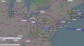
MD A-10s in New England from Oct 1-4, 2024

Here's a quick list of freqs used for A-A. Not going to bother posting all the ZBW and Portland freqs logged in and out of YANKEE MOA over NH.

Players: AXEMAN, RAVEN, WARDOG, DAGGER

A-A freqs logged:
139.600
228.100
266.600
271.400
293.300

Yankee MOA coordination - conflict/de-conflict
238.250
Short vid of a Maryland A-10 hitting the NH Mountains. :)


MUTNAV

Active Member
Premium Subscriber
Joined
Jul 27, 2018
Messages
1,302
Short vid of a Maryland A-10 hitting the NH Mountains. :)

Hopefully this isn't too far off topic, but this has been bothering me for awhile.

The question is... Do people and programs for aircraft flying nap of the earth profiles realize that height above average terrain means nothing to towers, which are measured above ground level of wherever they are mounted?

(in a 200' deep valley, you can't make your tower 400' to make up for it being in a valley)

On the other hand, at a homestead on top of a mountain, that has an outbuilding at the top, a tower can be 190 feet tall without any special lighting, and an A-10 pilot really needs to be higher than that.

If I understand the rules correctly.

I realize this could get a lot of emotions high, please take a few deep breaths.

Thanks
Joel
 

BM82557

Member
Joined
Aug 28, 2006
Messages
5,225
Location
Berkeley Co WV
TEFLON-21 KC135 AE04E6 59-1516 checked in with HUNTRESS 260.9 at 0620 local
NOBLE-11 checking in with Potomac tracon 269.5 at 0647 local
HUNTRESS to TEFLON-21, NOBLE-11 and 12 proceeding to tank 260.9 0649 local
NOBLE-11 to TEFLON-21, NOBLE-12 will be taking 10K, 11 will be back in 20 minutes to tank, 12 cleared to boom 231.625 0649 local
NOBLE-12 gives tail number as MA 85108 on 231.625 at 0654 local
TEFLON-21 and NOBLE-11 chatting, 21 gives take off time as 0920Z 0420 local, 21 out of Wisconsin, 231.625 0704 local
NOBLE-11 gives tail as 86178, looking for 10K, 231.625 0704 local
NOBLE 11 and 12 have been pretty chatty on A2A 259.9 , 11 mentioned it was 46 minutes from take off to Frederick (Maryland)
 

TerryPavlick

Member
Premium Subscriber
Joined
Apr 12, 2004
Messages
3,711
Location
Wallingford PA Villas NJ
Hopefully this isn't too far off topic, but this has been bothering me for awhile.

The question is... Do people and programs for aircraft flying nap of the earth profiles realize that height above average terrain means nothing to towers, which are measured above ground level of wherever they are mounted?

(in a 200' deep valley, you can't make your tower 400' to make up for it being in a valley)

On the other hand, at a homestead on top of a mountain, that has an outbuilding at the top, a tower can be 190 feet tall without any special lighting, and an A-10 pilot really needs to be higher than that.

If I understand the rules correctly.

I realize this could get a lot of emotions high, please take a few deep breaths.

Thanks
Joel
Trying to understand your question. Are you asking does the navigation software used for that type of flying include towers or anything man-made that may obstruct flight at those levels ?
 

Mark

Member
Premium Subscriber
Joined
Jan 14, 2001
Messages
14,571
Location
Northeast Maryland
There go the MacDill KC-135's on Evac again.. Come Weds another hurricane for that area. :(

GOLD-21 #16-46023 did the same Idaho topoff as below inbound Bangor first.
GOLD-31 #18-46049 went from Kansas to Eastern Idaho to pick up some Mountain Home F/15E's.
Tankers cut them loose around Nebraska.. Prob have their extended range fuel tanks all loaded up.
Seems to short of a turnaround time for Monday Altrav.. Maybe Tuesday?
 
Last edited:

Dutchmil

Member
Joined
Feb 3, 2015
Messages
630
Location
Amsterdam, the Netherlands
GOLD-21 #16-46023 did the same Idaho topoff as below inbound Bangor first.
GOLD-31 #18-46049 went from Kansas to Eastern Idaho to pick up some Mountain Home F/15E's.
Tankers cut them loose around Nebraska.. Prob have their extended range fuel tanks all loaded up.
Seems to short of a turnaround time for Monday Altrav.. Maybe Tuesday?

TABOR 71 and TABOR 81 flight were working Atlanta center this afternoon and then
switched to Washington center on 322.450. Still scheduled into EGUL tomorrow .... :)
 

MUTNAV

Active Member
Premium Subscriber
Joined
Jul 27, 2018
Messages
1,302
Trying to understand your question. Are you asking does the navigation software used for that type of flying include towers or anything man-made that may obstruct flight at those levels ?
I apologize, I meant like program in the sense of, this is how we have established to do things, maybe "system" is a better word.

Are there systems set up make it clear that the average height of low level missions can never go below 200 feet, or is it made clear that at no point can it go below 200 feet (except in the appropriate classes of airspace, obviously).

Terrain following radar operations, I believe, use the average altitude of the aircraft.

I still have to wonder if pilots are taught that their average altitude doesn't count when at very low level.

For example, are the told that It doesn't matter if they are terrain following, when they cross a ridge they still have to be more than 200 ft above the TOP of the ridge".

Thanks
Joel
 

Mark

Member
Premium Subscriber
Joined
Jan 14, 2001
Messages
14,571
Location
Northeast Maryland
TABOR 71 and TABOR 81 flight were working Atlanta center this afternoon and then
switched to Washington center on 322.450. Still scheduled into EGUL tomorrow .... :)
Doesn't make sense if tankers are tanking over Idaho up North and leave them around Lincoln Nebraska
then you say Tabors are in Atlanta/ ZDC Raleigh sector.
Nothing also on UHF thru here to Northeast today.Maybe they Staged down at SJ perhaps?
Come to think of it Lincoln Neb is a ways Southeast of Idaho and on course would put them into SJ :)
Usually the Idaho guys when deploying fly across Northern US along Canada border to Bangor/Pease for a stop.
Will keep an ear out for them in the AM.
 
Last edited:

Mark

Member
Premium Subscriber
Joined
Jan 14, 2001
Messages
14,571
Location
Northeast Maryland
1429L- NOBLE 31 flight of 2 checking in ZNY 290.2, direct to Lancaster
NOBLE-31 enroute CAP A/A 259.000 and on 290.200 here too push ZNY 322.400
NOBLE goofs on radio dial coming up on 302.400 saying 322.400.. oops. Now back on 322.400.
NOBLE now trying ZNY Modena on 335.600 no joy so back to 322.400
 
Last edited:

Mark

Member
Premium Subscriber
Joined
Jan 14, 2001
Messages
14,571
Location
Northeast Maryland
Sorry, should have been more clear, the MO F-15s went to Seymour-Johnson AFB today.
Guess Rene they said to heck with the extra 600 miles or so we need F-15E servicing at SJ.
Good for me anyway to catch them tomorrow if they are not too late getting out :)
Google maps say driving from Raleigh to Bangor is 944 miles or 3.5 hours flight time.LOL
 
Last edited:
Status
Not open for further replies.
Top