Duke Energy P25 is coming alive in NC

brian

DB Administrator
Database Admin
Joined
Dec 10, 2000
Messages
2,099
Location
South Carolina
I'm up to date on submissions at the moment. Keep them coming. Also, check behind me and make sure I didn't make mistakes on the new sites, especially with the location information.

Regarding some active sites not decoding with DSD+ at times, I have experienced the same thing occasionally. Either it's flakeyness is how DSD+ syncs up with the control channel data, or there's something weird with the data being transmitted as the sites are brought online and (presumably) tested.
 

IcomIcR20

Member
Premium Subscriber
Joined
Jun 16, 2014
Messages
842
Here are some more sites that I confirmed today. I believe this takes care of everything within a reasonable radius. If anyone can provide some proof that the sites further south (Albemarle, Troy, Asheboro, Mt. Gilliad, Siler City, etc) are indeed online, then perhaps I can make a trip over there before I am out-of-state again. That is a bit of a hike for me, so I would hate to drive all the way down there only to find that those sites are not online yet.

Firstly, I want to mention that 3D4-2.2, which should be Al's Knob Radio (WNPW328) in Rowan County, NC is not currently transmitting a control channel. I noted an extremely strong carrier on the frequency reported to be its CC by 2.2's neighbors when sitting at the site, but no data was being transmitted.

All other sites that I visited were active and are as follows:

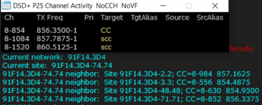
"Statesville 800" -- Iredell County, NC -- WPZS946/Pending
1702504867315.png

Neighbors: 2.2=Al's Knob Radio (Unconfirmed), 3.3=Anderson Mountain, 48.48=Sheffield, 71.71=Wilkesboro

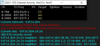
"Denton Radio" -- Davidson County, NC -- WNYK398
1702505035729.png

Neighbors: 2.2=Al's Knob Radio (Unconfirmed), 7.7=Arcadia 800, 38.38=High Point MW

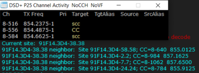
High Point MW -- Randolph County, NC -- WNAJ727
1702505217660.png

Neighbors: 2.2=Al's Knob Radio (Unconfirmed), 7.7=Arcadia 800, 24.24=Denton Radio, 58.58=Grennsboro/Old Randleman


At this time, all neighbors that I have seen on any of the sites I have personally monitored are now confirmed with the exception of 3D4-2.2 (Al's Knob Radio) since it is not currently transmitting data, 3D4-36.36 (Hibriten Mountain), and 3D4-63.63 (Rockingham CT Facility). The site in Western Yadkin County that is marked on @RaleighGuy's map does not seem to have been converted to P25 yet. The same goes for the site in Winston-Salem.


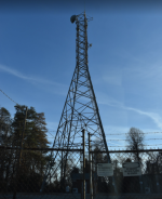
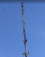
Picture of the Al's Knob site:
1702506165215.png

Picture of the High Point MW site:
1702506227739.png
 

RaleighGuy

Member
Premium Subscriber
Joined
Jul 15, 2014
Messages
14,479
Location
Raleigh, NC
@IcomIcR20 you sir are the best and I really appreciate your help, your reports have been spot on and full of good information. For someone on vacation visiting his family you've gone above and beyond. It's all part of the love of the hobby.

The site in Western Yadkin County that is marked on @RaleighGuy's map does not seem to have been converted to P25 yet. The same goes for the site in Winston-Salem.

Those towers may or may not be a part of the site, when I ran the list it was based on the Duke Energy name. Some of the sites may be abandoned or repurposed rather than made part of the Harris P25 system, I do not know.
 

IcomIcR20

Member
Premium Subscriber
Joined
Jun 16, 2014
Messages
842
@IcomIcR20 you sir are the best and I really appreciate your help, your reports have been spot on and full of good information. For someone on vacation visiting his family you've gone above and beyond. It's all part of the love of the hobby.


Those towers may or may not be a part of the site, when I ran the list it was based on the Duke Energy name. Some of the sites may be abandoned or repurposed rather than made part of the Harris P25 system, I do not know.
Always happy to help! Discovering new information is certainly one of my favorite parts of the hobby. I was not originally planning on driving to the sites today, but most of my family was otherwise occupied this afternoon so I had a few hours to spare.

I would be surprised if the Winston-Salem site is not eventually converted to P25, unless the Arcadia site has sufficient coverage in the city. However, it is a good ways south. Perhaps they could get by without the Yadkin County site, but it would definitely help coverage, especially for portables. Since it is already used for their OpenSky system, I don't see a real reason to decommission it. Plus, they have updated the site's license for P25 usage.
 

IcomIcR20

Member
Premium Subscriber
Joined
Jun 16, 2014
Messages
842
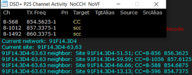
Another site confirmed:

"Rockingham CT Facility" -- Rockingham County, NC -- WPZT872
1702761085803.png
Neighbors: 13.13=Burlington (Unconfirmed), 51.51=Walnut Cove, 59.59=Reidsville, 66.66=Sauratown Mountain

A faint control channel was heard on 3D4-13.13's listed CC frequency, but much too weak to decode.
 

RaleighGuy

Member
Premium Subscriber
Joined
Jul 15, 2014
Messages
14,479
Location
Raleigh, NC
I'm wondering about a neighbor of site 397-46.46, it continues to list 397-91.91 the cc for it 855.5375 matches the Pilot site 397-49.49 in Zebulon. I'm wondering if it was a dummy site or if the site number in the system was never changed after 49.49 came online.
 

RaleighGuy

Member
Premium Subscriber
Joined
Jul 15, 2014
Messages
14,479
Location
Raleigh, NC
Appears six training units and three Grid units are working on the system today, not sure if they are just on the 397-46.46 site or others as well. See attached text file for edited event log showing units and alias. Unfortunately, no location data is being seen/logged.

Capture2.PNG
 

Attachments

  • Duke new traffic.txt
    2.3 KB · Views: 8

RaleighGuy

Member
Premium Subscriber
Joined
Jul 15, 2014
Messages
14,479
Location
Raleigh, NC
Appears six training units and three Grid units are working on the system today, not sure if they are just on the 397-46.46 site or others as well. See attached text file for edited event log showing units and alias. Unfortunately, no location data is being seen/logged.

View attachment 153289

From searches on Google for Duke Energy...

DCC = Distribution Control Center
ECC = Energy Control Center
NOC = Network Operations Center
 

RaleighGuy

Member
Premium Subscriber
Joined
Jul 15, 2014
Messages
14,479
Location
Raleigh, NC
New sites found this morning, thanks to good propagation, 397-39.39 (Lillington, Harnett Co, NC) verified, 397-66.66 (Sanford, Lee County, NC) unconfirmed. Submitted to database, RR Wiki page updated.

Capture2.PNG
 

RaleighGuy

Member
Premium Subscriber
Joined
Jul 15, 2014
Messages
14,479
Location
Raleigh, NC
Changes made on Site 397-4.4, CC changed to 855.9375 from 859.3875 and two sites (3D4-29.29 & 3D4-69.69) dropped from neighbor list. I'm sure as setup continues across the state we will continue to see minor changes like these.

Also, was able to take a trip up to Henderson NC, and Castalia NC, and it appears both those sites are not activated yet. I was only a mile or so from the tower locations of each site and was unable to pickup the signal or see any spike on DSD+ FL.
 

IcomIcR20

Member
Premium Subscriber
Joined
Jun 16, 2014
Messages
842
Another site for ya'll:

Was able to just barely copy "China Grove MW" -- Rowan County -- WNPW328
1703736038493.png

The neighbor data may be incomplete as the signal was extremely weak, and only a portion of the data was getting decoded successfully. It took several minutes fiddling with the antenna to get any sort of useable signal. @N4LHY_1 can likely copy this site better than I can.

3D4-3.3 is Anderson Mountain (confirmed), and 3D4-2.2 is Al's Knob which is still transmitting only a carrier as far as I can tell. 3D4-81.81 is likely "Winecoff Tie" (Cabarrus County, WPZS940), but I am not entirely sure what "FAILED, Info Outdated, ISOLATED" means as I have not seen that before.
 

lwvmobile

DSD-FME
Joined
Apr 26, 2020
Messages
1,297
Location
Lafayette County, FL
I am not entirely sure what "FAILED, Info Outdated, ISOLATED" means

The signaling bits in octet 3 have the following meaning.
C (octet 3, bit 7) - This field specifies if the adjacent status broadcast is for a
conventional channel. A value of 1 indicates the adjacent broadcast is
advertising a conventional channel.
F (octet 3, bit 6) - This field specifies if the site is in a failure condition. A value of 1
indicates the site is in a failure condition.
V (octet 3, bit 5) - If the information contained in the adjacent status broadcast is known
to be correct, this should be set to 1. If the site is not communicating with the
adjacent site, this should be set to 0. In the case of a 0 value, the data in the rest
of the adjacent status broadcast is the last known correct data.
A (octet 3, bit 4) - This field specifies if the site has an active network connection with
the RFSS controller, i.e., communication with other sites is possible. A value of 1
indicates a valid RFSS network connection is active.
 

IcomIcR20

Member
Premium Subscriber
Joined
Jun 16, 2014
Messages
842
Another one:

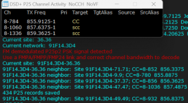
"Hibriten Mountain Radio" -- Caldwell County, NC -- WNSK755
1704393760876.png

3D4-47.47 is likely McDowell TIE (WQOY788), and 3D4-49.49 is likely Mount Ida Radio (WNSK751). The other neighbors have been confirmed.
 

IcomIcR20

Member
Premium Subscriber
Joined
Jun 16, 2014
Messages
842
I forgot to mention, but 3D4-23.23 was showing a neighbor that I do not see in the Wiki:

3D4-89.89 - CC=854.5625 - The only Duke licenses I am seeing for this frequency corresponds to Al's Knob Radio, which should be 3D4-2.2, and Rockingham CT Facility which is 3D4-63.63. Perhaps there is some pending license that is not showing up in my search in Radioreference. The ULS is not loading for me at the moment.
 
Top