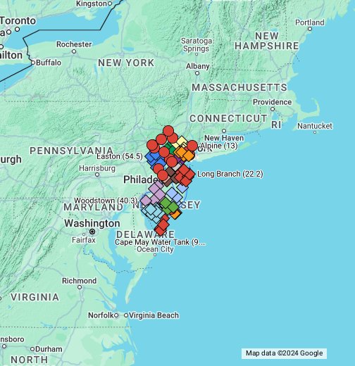
I haven't updated that map in ages. Let me see what I can do.@GTR8000 in looking at the map on the wiki, it's about 4 years old. Are you looking to throw in the new changes or is someone else managing the map these days? It's actually "better" than the one the state provides (for internal and external users).
You are using an out of date browser. It may not display this or other websites correctly.
You should upgrade or use an alternative browser.
You should upgrade or use an alternative browser.
New Jersey Interoperability Communication System (NJICS)
- Thread starter etr37
- Start date
Thanks. I know alot of changes came about last year with some of us driving around to find out what sites went to what cells. I guess one could just look at the database and figure out which site is in which cell. For me...I'm a visual kinda guy...LOLI haven't updated that map in ages. Let me see what I can do.
I can help you a bit with the southern end of the state from Burlington County on down.I haven't updated that map in ages. Let me see what I can do.
That's the best I can do for now, as I'm probably not going to be updating that static map in the wiki anymore, it's too much of a PIA to maintain.
No guarantee of the accuracy of the Google mapping, and for those in the know, the simulcast cell subsite ID's might be wrong in some instances, so take it all with a grain of salt.
- Joined
- Dec 22, 2005
- Messages
- 2,003
What no radio ID’s? Only kidding! Long overdo apologies. That IS a very impressive map. Much more than ICS and no surprise, precise. 👏 Local knowledge evident.
That's the best I can do for now, as I'm probably not going to be updating that static map in the wiki anymore, it's too much of a PIA to maintain.
No guarantee of the accuracy of the Google mapping, and for those in the know, the simulcast cell subsite ID's might be wrong in some instances, so take it all with a grain of salt.
Good idea to use Google. More dynamic and easier to change. Google Earth KMZ file...might be something I can work on in my spare time
That's the best I can do for now, as I'm probably not going to be updating that static map in the wiki anymore, it's too much of a PIA to maintain.
No guarantee of the accuracy of the Google mapping, and for those in the know, the simulcast cell subsite ID's might be wrong in some instances, so take it all with a grain of salt.
Network linked KMZ.Good idea to use Google. More dynamic and easier to change. Google Earth KMZ file...might be something I can work on in my spare time
Confirmed corrections to errors or omissions are welcome...within reason, of course...I'm not going to move a site marker 2 feet to the left because it's not centered directly over the tower. 🙃
Attachments
...I'm not going to move a site marker 2 feet to the left because it's not centered directly over the tower. 🙃
Why are you looking at me when you say that?
(guilty self-deprecating joke)
I have re-confirm the West Orange tower. I thought it was across the st at the reservation. At some point the Freehold site will need to move (and it will be more than 2 feet for sure), but scrolling through the others...looks really good.Network linked KMZ.
Confirmed corrections to errors or omissions are welcome...within reason, of course...I'm not going to move a site marker 2 feet to the left because it's not centered directly over the tower. 🙃
APX8000
Sarcastic Member
I believe you are correctI have re-confirm the West Orange tower. I thought it was across the st at the reservation.
APX8000
Sarcastic Member
Yeah you will. OCD overload.Network linked KMZ.
Confirmed corrections to errors or omissions are welcome...within reason, of course...I'm not going to move a site marker 2 feet to the left because it's not centered directly over the tower. 🙃
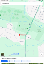
Freehold moved a few months ago to the water tower near the intersection of Jackson Mills and Stone Hill Rd at the south end of the township.The KMZ looks good. The .1 .2 and so on with colors on the simulcast helpful.
On Freehold, must be getting closer as Marlboro just filed MW as completed.
I would love to know what “Chicken TR” is on the telephone pole🤔.
Okay, a few sites have been adjusted, two added to the Cumberland County cell. The status of some of the Cape May County sites is uncertain. They were allegedly moving the courthouse/library site at some point. I believe my map shows the new site, however the state's coverage map appears to show the site at the original location. Anyway, close enough unless someone has confirmed info.
Similar threads
- Replies
- 19
- Views
- 3K
- Replies
- 12
- Views
- 3K
- Replies
- 2
- Views
- 1K
- Replies
- 4
- Views
- 911


